Abstract
By using the observation data from 89 weather stations in Xinjiang during 1961–2010, this paper analyzed the basic climatic elements including temperature, precipitation, wind speed, sunshine duration, water vapor pressure, and dust storm in the entire Xinjiang and the subareas: North Xinjiang, Tianshan Mountains, and South Xinjiang. The results indicate that from 1961 to 2010 the annual and seasonal mean temperatures in the entire Xinjiang show an increasing trend with the increasing rate rising from south to north. The increasing rate of annual mean minimum temperature is over twice more than that of the annual mean maximum temperature, contributing much to the increase in the annual averages. The magnitude of the decrease rate of low-temperature days is larger than the increase rate of high-temperature days. The increase of warm days and warm nights and the decrease of cold days and cold nights further reveal that the temperature increasing in Xinjiang is higher. In addition, annual and seasonal rainfalls have been increasing. South Xinjiang experiences higher increase in rainfall amounts than North Xinjiang and Tianshan Mountains. Annual rainy days, longest consecutive rainy days, the daily maximum precipitation and extreme precipitation events, annual torrential rain days and amount, annual blizzard days and amount, all show an increasing trend, corresponding to the increasing in annual mean water vapor pressure. This result shows that the humidity has increased with temperature increasing in the past 50 years. The decrease in annual mean wind speed and gale days lessen the impact of dust storm, sandstorm, and floating dust events. The increase in annual rainy days is the cause of the decrease in annual sunshine duration, while the increase in spring sunshine duration corresponds with the decrease in dust weather. Therefore, the increase in precipitation indicators, the decrease in gales and dust weather, and the increasing in sunshine duration in spring will be beneficial to crops growth.
Keywords
Xinjiang ; temperature ; precipitation ; dust storm ; extreme climate event
1. Introduction
The IPCC AR4 pointed out that in the past 100 years the global climate has been experiencing significant changes characterized by global warming [ IPCC, 2007 ]. This warming has also been observed in China [ ECSNARCC, 2011 ]. In the past 50 years, the climate in the northwestern China has turned from dry and warm to wet and warmer [ Xu, 1997 , Shi et al., 2002 , Shi et al., 2003 , Li et al., 2003 , Song and Zhang, 2003 , Yu et al., 2003 , Zhang and Shi, 2002 , Yang, 2003 and Hu et al., 2002 ]. Especially in Xinjiang a strong change has taken place [ Zhao, 2006 ]. Due to its unique geographical position and vulnerable ecological environment, Xinjiang is very sensitive to climate change [ Hu et al., 2001 ]. Shi [2003] pointed out that the climate in Xinjiang changed abruptly in 1987 and in most areas obvious climate changes have been observed except in the Taklimakan Desert. By using the latest meteorological data, this paper analyze the spatial and temporal characteristics of climate changes in Xinjiang to provide references for the development in society, economy, agriculture, ecological environment, etc.
2. Data and methods
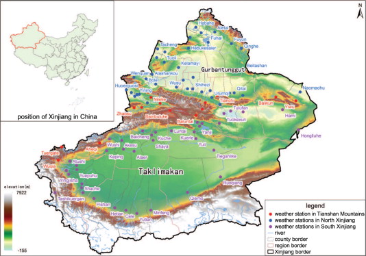
The data used in this paper are from quality-controlled observations of 89 weather stations in Xinjiang from 1961 to 2010, including daily mean temperature, maximum temperature, minimum temperature, precipitation, mean wind speed, sunshine duration, and water vapor pressure. The time period for daily precipitation is from last 8:00 pm to 8:00 pm. The entire Xinjiang encompasses all the selected stations. North Xinjiang, Tianshan Mountains, and South Xinjiang refer to the stations marked in Figure 1 .
|
|
|
Figure 1. Distribution of 89 meteorological stations in Xinjiang |
The average value for one element is the arithmetic average of all weather stations inside the region. The average value of 1971–2000 is taken as the reference mean value. One year refers to the 12 months from January to December; spring is from March to May, summer from June to August, autumn from September to November, and winter from last December to February. Annual blizzard days and blizzard amounts refer to the days and amounts accumulated from July to next June.
3. Trends in temperature
3.1. Mean temperature
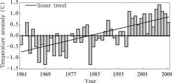
During 1961–2010, the annual mean temperatures in Xinjiang and the subareas (North Xinjiang, Tianshan Mountains and South Xinjiang) show a significant increasing trend with a rate of 0.32°C per decade (0.37, 0.34 and 0.26°C per decade respectively), which is higher than the global rising rate of 0.13°C per decade [ IPCC , 2007 ] and the rate of 0.22°C per decade over whole China for the same period [ECSNARCC , 2007]. After the 1990s, Xinjiang is found to become warmer with the annual mean temperature continuously above normal for 14 years. In total, the temperature rose by 1.3°C in the 2000s compared to the 1960s ( Fig. 2 ).
|
|
|
Figure 2. Variation of annual mean temperature anomalies in Xinjiang during 1961–2010 |
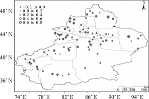
For the spatial distribution, except some stations in South Xinjiang, all recorded annual mean temperatures show a clear increasing trend, of which the most notable rise is observed at Fuyun station in the eastern part of North Xinjiang and Balikun station in the eastern part of Tianshan Mountains with an increase rate of 0.6–0.8°C per decade (Fig. 3 ).
|
|
|
Figure 3. Spatial distribution of trends in annual mean temperatures in Xinjiang during 1961–2010 (solid circle denotes the trend significant at the 95% confidence level; unit: °C per decade) |
From the seasonal variations, it can be seen that in the late 50 years all the mean temperatures in spring, summer, autumn and winter in Xinjiang and the three subareas showed obvious increasing tendencies. Especially the increase rate of temperature in winter and autumn is larger than the increase rate in other seasons, which contributes more to the increasing of annual mean temperatures (Table 1 and Table 2 ).
| Item | Definition |
|---|---|
| Extreme high temperature | Maximum daily temperature in a year |
| Extreme low temperature | Minimum daily temperature in a year |
| High-temperature day | Daily maximum temperature ≥ 35°C |
| Low-temperature day | Daily minimum temperature ≤–20°C |
| Warm day | Daily maximum temperature > the 90th percentile |
| Warm night | Daily minimum temperature > the 90th percentile |
| Cold day | Daily maximum temperature < the 10th percentile |
| Cold night | Daily minimum temperature < the 10th percentile |
| Extreme rainfall | Daily precipitation > the 95th percentile |
| Rainy day | Daily precipitation amount ≥ 0.1mm |
| Torrential rain | Precipitation ≤ 24.1 mm within 24 h |
| Blizzard | Snow is observed with daily precipitation ≥ 12.1 mm within 24 h or snow cover ≥ 10.0 cm with daily precipitation ≥ 12.1 mm |
| Gale | Instantaneous wind speed ≥ 17.0 m s−1 |
| Dust storm | Strong winds blow loose sand from a dry surface, making the horizontal visibility less than 1.0 km |
| Sandstorm | Strong winds blow sand up into the air, making the horizontal visibility greater than 1.0 km but less than 10.0 km |
| Floating dust | Sand evenly floating in the air, making the horizontal visibility less than 10.0 km |
| Region | Annual | Spring | Summer | Autumn | Winter |
|---|---|---|---|---|---|
| Xinjiang | 0.32* | 0.24* | 0.19* | 0.38* | 0.45* |
| North Xinjiang | 0.37* | 0.25 | 0.22* | 0.47* | 0.50* |
| Tianshan | 0.34* | 0.22* | 0.28* | 0.44* | 0.40* |
| South Xinjiang | 0.26* | 0.21* | 0.14* | 0.26* | 0.41* |
Note:
- . denotes the trend significant at the 95% confidence level
The annual mean maximum and minimum temperatures in the whole Xinjiang also show an significant increasing trend, with the increasing rate of 0.25 and 0.54°C per decade respectively. The increasing trend of the annual mean minimum temperature is over twice as much as that of the maximum temperature, contributing more to the increase in annual mean temperatures. Considering the spatial distribution, the annual mean maximum and minimum temperature present a consistent increase; the north part of North Xinjiang and the west part of South Xinjiang have experienced the most noticeable increase. Moreover, for all stations it is observed that the linear trend of the annual mean minimum temperature is higher than that of the maximum temperature (Fig. 4 ).
|
|
|
Figure 4. Spatial distribution of trends in annual mean maximum temperatures (a), and annual mean minimum temperatures (b) in Xinjiang during 1961–2010 (solid circle denotes the trend significant at the 95% confidence level; unit: °C per decade) |
3.2. Extreme temperature
During 1961–2010, the extreme high temperatures of Xinjiang region and the subareas (North Xinjiang, Tianshan Mountains, and South Xinjiang) show a slight increase while the extreme low temperatures increase more obviously (Table 3 ). The warm days and warm nights occurred more frequently in the second half part of the research period. The increase of warm nights is larger than that of warm days. Comparatively, the cold days and cold nights are decreasing. Cold days in South Xinjiang do not decrease much, but the decreasing in cold nights is more significant. The change of warm events increasing and cold events decreasing does further underline the warming.
| Element | Xinjiang | North Xinjiang | Tianshan | South Xinjiang |
|---|---|---|---|---|
| Extreme high temperature (°C per decade) | 0.09 | 0.09 | 0.04 | 0.09 |
| Extreme low temperature (°C per decade) | 0.75* | 0.87* | 0.66* | 0.65* |
| Warm days (d per decade) | 3.58* | 2.63* | 3.05* | 4.68* |
| Warm nights (d per decade) | 6.75* | 6.68* | 8.11* | 6.32* |
| Cold days (d per decade) | –2.09* | –2.24* | –2.35* | –1.86 |
| Cold nights (d per decade) | –6.59* | –6.94* | –6.93* | –6.11* |
| High temperature days (d per decade) | 0.61* | 0.57 | 0.00 | 0.88* |
| Low temperature days (d per decade) | –2.20* | –3.62* | –2.65* | –0.65 |
Note:
- . denotes the trend significant at the 95% confidence level
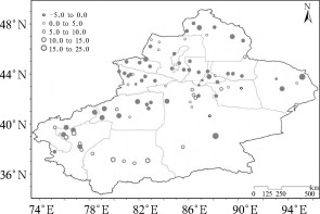
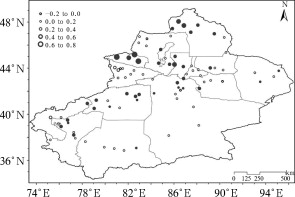
Similarly, high-temperature days over 1961–2010 present a rising trend in general, and the increasing trend is more apparent especially in Xinjiang region and South Xinjiang. In comparison, low-temperature days are decreasing. The magnitude of decreasing trend in low-temperature days is much larger than that of the increasing trend in high-temperature days. The low-temperature days in North Xinjiang reduce at the speed of 6 times more than the increase speed of high-temperature days. The decrease of low-temperature days contributes even more to the increase of annual mean temperatures. This conclusion is consistent with the result that the increase of annual mean minimum and extreme low temperatures contribute more to the increase of annual mean temperatures, i.e., the rise of minimum temperature contributes more to the rise of annual mean temperature than the increase in maximum temperatures (Table 3 ).
For the spatial distribution, high-temperature days show an increasing trend in most of Xinjiang. The eastern part of South Xinjiang is observed with the most notable increase while the two sides of Tianshan Mountains and the southern part of the Tarim Basin have a descending trend. However, the tendencies in low-temperature days do not have much regional difference. Except the southwestern part of the Tarim Basin and some areas of eastern Xinjiang, all the other parts show a descending trend, of which the reduction in North Xinjiang is the most significant (Fig. 5 ).
|
|
|
Figure 5. Spatial distribution of trends in high-temperature days (a), and low-temperature days (b) in Xinjiang during 1961–2010 (solid circle denotes the trend significant at the 95% confidence level; unit: °C per decade) |
4. Trends in precipitation
4.1. Rainfall amount
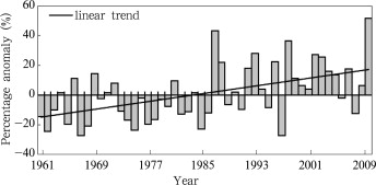
During 1961–2010, the annual precipitation amount for the Xinjiang region and the subareas (North Xinjiang, Tianshan Mountains, and South Xinjiang) show a noticeable upward trend, of which the increase in South Xinjiang is the most obvious with a rate of 9.5% per decade, contributing most to the growth rate (6.5% per decade) for the whole Xinjiang region. The next contributing region is North Xinjiang, with about 6.8% per decade, while Tianshan Mountains only increases at the speed of 4.6% per decade. Generally, the Xinjiang region has continuously received more rainfall since 1987 with the rainfall amount having increased by 26% in the 2000s compared to the 1960s (Fig. 6 ). This result corresponds to the findings by Wang and Zhai [2008] that the annual precipitation in North China, the Northeast and the east of the Northwest has shown a decreasing trend while the western part of the Northwest China has observed with a notable increasing precipitation amount with a rate of 4.5% per decade.
|
|
|
Figure 6. Variations of annual precipitation percentage anomalies in Xinjiang during 1961–2010 |
In addition, the spatial distribution of the increasing linear trend in annual precipitation shows that the north part of North Xinjiang, eastern Xinjiang and southern Tianshan have the most significant upward trends (Fig. 7 ).
|
|
|
Figure 7. Spatial distribution of trends in annual precipitation percentage anomalies (%) in Xinjiang during 1961–2010 (solid circle denotes the trend significant at the 95% confidence level; unit: % per decade) |
From the seasonal variation, it can be seen that the precipitation amount in the four seasons in the Xinjiang region and the subareas has significantly increased in the past 50 years (Table 4 ).
| Region | Annual | Spring | Summer | Autumn | Winter |
|---|---|---|---|---|---|
| Xinjiang | 6.5* | 5.4* | 5.2* | 6.0* | 15.2* |
| North Xinjiang | 6.8* | 5.5 | 5.2* | 4.8 | 15.9* |
| Tianshan | 4.6* | 4.6* | 3.8* | 4.3* | 13.6* |
| South Xinjiang | 9.5* | 6.7 | 8.1* | 16.5* | 13.4 |
Note:
- . denotes the trend significant at the 95% confidence level
4.2. Rainy days and the longest consecutive rainy days
During 1961–2010, annual rainy days in Xinjiang region and the subareas (Northern Xinjiang, Tianshan Mountains, Southern Xinjiang) increase with rate of 1.9 d per decade (2.5, 1.7 and 1.4 d per decade respectively). The spatial distribution of the trends in annual rainy days does not show much regional difference; almost all the regions show increasing trend, with the most obvious increase in Bozhou of western North Xinjiang (Fig. 8 ).
|
|
|
Figure 8. Spatial distribution of trends in annual rainy days in Xinjiang during 1961–2010 (solid circle denotes the trend significant at the 95% confidence level; unit: d per decade) |
The longest consecutive rainy days in Xinjiang and North Xinjiang show a noticeable increasing trend with a rate of 0.12 and 0.22 d per decade, respectively. However, the longest consecutive rainy days in Tianshan Mountains and South Xinjiang do not increase obviously (0.001 and 0.07 d per decade respectively).
4.3. Extreme precipitation
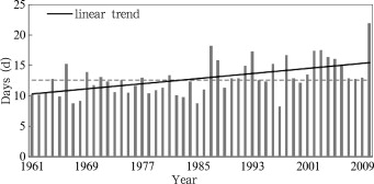
During 1961–2010, more extreme precipitation events occur in Xinjiang region and the subareas (North Xinjiang, Tianshan Mountains and South Xinjiang), with a clear increase by 1.0 d per decade (1.2, 1.2 and 0.9 d per decade respectively). This trend is consistent with the increase in precipitation amount. Along with the rise, the variability of annual extreme precipitation events also has increased. The year with the least extreme precipitation events (8.2 d) is 1997 and the year with the most (21.9 d) is 2010 (Fig. 9 ).
|
|
|
Figure 9. Variation of extreme precipitation days in Xinjiang during 1961–2010 |
During 1961–2010, daily maximum precipitation in the whole Xinjiang displays a remarkable increase. Additionally, the annual torrential rain days and amount, the blizzard days and amount all show a clear increasing trend. The increase rate of annual torrential rain days is higher than that of the annual blizzard days, while the rate of the annual blizzard amount is much larger than the annual torrential rain amount (Table 5 ). Based on the above analysis, it can be concluded that under the background of global warming and regional warming in Xinjiang, the occurrence of extreme precipitation events has increased.
| Region | Daily maximum precipitation (mm per decade) | Annual torrential rain days (d per decade) | Annual torrential rain amount (% per decade) | Annual blizzard days (d per decade) | Annual blizzard amount (% per decade) |
|---|---|---|---|---|---|
| Xinjiang | 0.84* | 0.05* | 15.6* | 0.03* | 21.1* |
| North Xinjiang | 0.96* | 0.05* | 20.4* | 0.06* | 44.5* |
| Tianshan | 1.05* | 0.14* | 13.8* | 0.03 | 6.0 |
| South Xinjiang | 0.65* | 0.02 | 12.6 | 0.01* | 46.7* |
Note:
- denotes the trend significant at the 95% confidence level
4.4. Water vapor pressure
During 1961–2010, the annual mean water vapor pressure in the whole Xinjiang shows an increasing trend, corresponding with the increasing in precipitation. The seasonal mean water vapor pressure also increases. For example, the increase in summer is consistent with the noticeable increase in summer rainfall amount. The increase in spring is the lowest (Table 6 ). The spatial distribution of the trends in annual mean water vapor pressure does not show much regional difference; increasing is observed in most of the region.
| Region | Annual | Spring | Summer | Autumn | Winter |
|---|---|---|---|---|---|
| Xinjiang | 0.16* | 0.08* | 0.26* | 0.21* | 0.09* |
| North Xinjiang | 0.16* | 0.07 | 0.29* | 0.18* | 0.07* |
| Tianshan | 0.10* | 0.05 | 0.26* | 0.18* | 0.08* |
| South Xinjiang | 0.16* | 0.05 | 0.27* | 0.20* | 0.09* |
Note:
- . denotes the trend significant at the 95% confidence level
5. Gale, dust weather and sunshine duration
5.1. Gale and dust weather
During 1961–2010, the whole Xinjiang has experienced a decrease in both the annual mean wind speed and the gale days. The decrease in North Xinjiang is most remarkable, being the strongest contributor to the decrease for the whole region of Xinjiang, while the decrease in Tianshan Mountains is the weakest. In addition, the annual dust storm, sandstorm, and floating dust events show an overall decline, of which the decrease in South Xinjiang is the most significant, contributing highest to the decrease over the whole Xinjiang (Table 7 ).
| Element | Xinjiang | North Xinjiang | Tianshan | South Xinjiang |
|---|---|---|---|---|
| Annual mean wind speed (m s−1 per decade) | –0.19* | –0.22* | –0.08* | –0.20* |
| Annual gale days (d per decade) | –4.03* | –5.72* | –1.22* | –3.43* |
| Annual dust storm days (d per decade) | –1.63* | –1.03* | –0.33* | –2.69* |
| Annual sandstorm days (d per decade) | –2.90* | –1.54* | –0.58* | –5.07* |
| Annual floating dust days (d per decade) | –4.89* | –0.09 | –1.30* | –10.89* |
Note:
- . denotes the trend significant at the 95% confidence level
In general, gales usually prevail in spring and summer in Xinjiang. The mean wind speeds of spring and summer both have clearly declined. The obvious decrease in gale days corresponds with the reduction of the mean wind speed in spring and summer. Strong winds are the dynamic trigger for the occurrence of dust weather, so the decrease of gale days in Xinjiang is one of the main factors that cause dust storm, sandstorm, and floating dust to decrease significantly.
Regarding the distribution of the linear trends in annual mean wind speed, decreasing trends are mostly found except some stations located in the mountains. The decrease is more obvious in North Xinjiang than in South Xinjiang. The annual gale days over Xinjiang decrease as well, being concordant with the decrease in annual mean wind speed. Similarly, the decrease in gale days is more obvious in North Xinjiang than in South Xinjiang. However, in Tianshan Mountains and some places in South Xinjiang, increase in gale days is observed.
A strong north-south disparity of spatial pattern in annual gale days is found. In North Xinjiang, annual gale days are 1.5 times as often as those in South Xinjiang. In contrary, the spatial distribution of annual dust storm days is vice versa. The dust storm days in South Xinjiang is 2.7 times as often as those in North Xinjiang. Comparing the spatial distribution of linear trends in annual dust storm days and gale days, it can be seen that the decrease in gale days in North Xinjiang is larger than that in South Xinjiang, while the decrease in dust storms in South Xinjiang is larger than that in North Xinjiang. This is closely correlated with the spatial distributions of annual gale days and dust storm days. This means that in the areas where gales and the dust storms occur more often, the decrease is usually more obvious (Fig. 10 ).
|
|
|
Figure 10. Spatial distribution of trends in annual gale days and annual dust storm days in Xinjiang during 1961–2010 (solid circle denotes the trend significant at the 95% confidence level; unit: d per decade) |
5.2. Sunshine duration
During 1961–2010, annual sunshine duration in the whole Xinjiang decreases obviously. From the seasonal variation, it can be seen that in spring it shows a slight increasing trend, but in the other seasons the trends are the opposite, of which sunshine duration in winter decreases most significantly (Table 8 ). For the spatial distribution, annual sunshine duration in most parts of Xinjiang is declining. In the western part of North Xinjiang and the two sides of Tianshan Mountains, the sunshine duration decreases more obviously, while in the areas around the Junggar Basin of North Xinjiang, the southwestern part of the Tarim Basin of South Xinjiang and the Hami prefecture, the sunshine duration is increasing.
| Region | Annual | Spring | Summer | Autumn | Winter |
|---|---|---|---|---|---|
| Xinjiang | –21.79* | 3.24 | –4.36 | –6.01* | –15.18* |
| North Xinjiang | –20.52* | 3.25 | –2.36 | –4.87 | –18.55* |
| Tianshan | –44.26* | –4.90 | –12.81* | –11.30* | –15.47* |
| South Xinjiang | –14.73* | 6.11 | –3.32 | –4.95 | –11.70* |
Note:
- . denotes the trend significant at the 95% confidence level
In China, Xinjiang is one of the regions with the most sunshine duration [ Lü and Xu, 1996 ]. The trends in sunshine duration are closely related to the changes in rainy days and dust weather. Increase in annual rainy days leads to the decrease in annual sunshine duration. The increase in annual rainfall amounts and days causes the reduction in dust weather. Moreover, the increase of sunshine duration in spring is corresponding to the decrease of dust weather. Xinjiang is located in the arid areas [ Zhang and Zhang, 2006 ], so the increase in precipitation is beneficial for agriculture and the decrease in dust weather lessens the dust on crop leaves. This is favorable for the photosynthesis of crops and good for agricultural production. The reduction in sunshine duration is unfavorable for agriculture. However in spring, the critical period for spring seeding, sunshine duration is increasing, which is quite beneficial for crops.
6. Conclusions
During 1961–2010, the annual mean temperatures in the entire Xinjiang and the subareas (Northern Xinjiang, Tianshan Mountains, and Southern Xinjiang) display an significant increasing trend with a rate of 0.32°C per decade (0.37, 0.34, 0.26°C per decade respectively), with the spatial increase from south to north. The temperature rises most remarkably at Fuyun station in eastern North Xinjiang and Balikun station in eastern Tianshan Mountains where the population density is very small. The Balikun station is a representative weather station in the eastern part of the Tianshan Mountains. Balikun is a county where people live on livestock breeding and not many human activities take place, so the urbanization effect in the local area has little impact on the temperature increase. The seasonal mean temperatures increase greatly, and winter and autumn have the greatest growth rate. The increase of annual mean minimum temperature is over twice as much as that of annual mean maximum temperature, which contributes much more to the increasing in annual mean temperature. The decrease rate of low-temperature days is larger than the increase rate of high-temperature days. Warm days and warm nights are increasing, but cold days and cold nights are decreasing. All these facts reveal that under the background of global warming the temperatures in Xinjiang increase at a high speed.
The annual and seasonal precipitation amounts in the whole Xinjiang increase as well. The increase in South Xinjiang is stronger than that in North Xinjiang and Tianshan Mountains. The strongest increase in precipitation appears in the Tianshan Mountains. Besides, annual rainy days, the longest consecutive rainy days, the daily maximum precipitation, the extreme precipitation events, the annual torrential rain days and amount, and the annual blizzard days and amount all show an increasing trend. Annual average water vapor pressure has a notable increase trend too, which is consistent with the trends in all the related precipitation indicators. These facts suggest that the humidity has increased a lot in Xinjiang in the recent 50 years, as the climate grows warmer.
The annual mean wind speed and gale days over the whole Xinjiang show a clear decline. The obvious reduction in wind speed causes the decrease in dust storm, sandstorm, and floating dust, especially over the areas with more gales. The trend in sunshine duration in Xinjiang is well correlated with the trends in precipitation indicators and dust weather. The high increase in annual rainy days leads to the decrease in annual sunshine duration. The increase of sunshine duration in spring is corresponding with the decrease in dust weather. In conclusion, the increase in rainfall, the reduction of gales and dust weather, and the increase in spring sunshine duration are very favorable for agricultural production.
Acknowledgements
This research was supported by China Meteorological Administration (CMA) Specific Research on Climate Change (No. CCSF-10-06), CMA 2013 Specific Research on Climate Change entitled variation and impact of extreme precipitation events in Xinjiang under the background of global warming, and the National Key Scientific Research Program of Global Change (No. 2010CB951001). The authors are very grateful to Prof. CHEN Hong-Wu and Prof. MAO Wei-Yi for their supports and instructions during the process of writing this paper. We also appreciate the reviewers and editors very much for their suggestions and hard work to improve this paper.
Received: 29 January 2013
References
- ECSNARCC, 2011 ECSNARCC (Editorial Committee of the Second National Assessment Report on Climate Change; The Second National Assessment Report on Climate Change (in Chinese)Science Press (2011), p. 710
- Hu et al., 2001 R.-J. Hu, Z.-L. Fan, Y.-J. Wang, et al.; Assessment about the impact of climate change on environment in Xinjiang since recent 50 years; Arid Land Geography (in Chinese), 24 (2) (2001), pp. 97–103
- Hu et al., 2002 R.-J. Hu, F.-Q. Jiang, Y.-J. Wang; A study on signals and effects of climatic pattern change from warm-dry to warm-wet in Xinjiang; Arid Land Geography (in Chinese), 25 (3) (2002), pp. 194–200
- IPCC, 2007 IPCC; ,in: R.K. Pachauri (Ed.), et al. , Climate Change 2007: The Synthetical Report. Contributions of Working Group I, II, and III to the Fourth Assessment Report of the Intergovernmental Panel on Climate Change (2007), p. 104 Geneva
- Li et al., 2003 D.-L. Li, L. Wei, Y. Cai, et al.; The present facts and the future tendency of the climate change in Northwest China; Journal of Glaciology and Geocryology (in Chinese), 25 (2) (2003), pp. 128–135
- Lü and Xu, 1996 S.-Q. Lü, S.-G. Xu; Xinjiang Energy Handbook; Press, Xinjiang People (1996)
- Shi, 2003 Y.-F. Shi; Assessment on Problems of Climate Changing from Dry-Warm to Wet-Warm in Northwest of China (in Chinese) ; Science Press (2003)
- Shi et al., 2002 Y.-F. Shi, Y.-P. Shen, R.-J. Hu; Preliminary study on signal, impact and foreground of climatic shift from warm-dry to warm-humid in Northwest China; Journal of Glaciology and Geocryology (in Chinese), 24 (3) (2002), pp. 219–226
- Shi et al., 2003 Y.-F. Shi, Y.-P. Shen, D.-L. Li, et al.; Discussion on the present climate change from warm-dry to warm wet in Northwest China; Quaternary Sciences (in Chinese), 23 (2) (2003), pp. 152–164
- Song and Zhang, 2003 L.-C. Song, C.-J. Zhang; Changing features of precipitation over Nothwest China during the 20th century; Journal of Glaciology and Geocryology (in Chinese), 25 (2) (2003), pp. 136–141
- Wang and Zhai, 2008 X.-L. Wang, P.-M. Zhai; Changes in China’s precipitation in various categories during 1957–2004; Journal of Tropical Meteorology (in Chinese), 24 (5) (2008), pp. 459–466
- Xu, 1997 G.-C. Xu; Climate Change in Arid and SemiArid Areas of China (in Chinese) ; China Meteorological Press, 45–65 (1997)
- Yang, 2003 L.-M. Yang; Climate change of extreme precipitation in Xinjiang; Acta Geographica Sinica (in Chinese), 58 (4) (2003), pp. 577–583
- Yu et al., 2003 S.-Q. Yu, X.-C. Lin, X.-D. Xu; The climatic change in Northwest China in recent 50 years; Climatic and Environmental Research (in Chinese), 8 (1) (2003), pp. 9–18
- Zhang and Shi, 2002 J.-B. Zhang, Y.-G. Shi; Study on Climate Change and Short-Term Climate Prediction in Xinjiang (in Chinese) ; China Meteorological Press, 21–85 (2002)
- Zhang and Zhang, 2006 X.-W. Zhang, J.-B. Zhang; Xinjiang Meteorological Handbook (in Chinese) ; China Meteorological Press, 72–81 (2006)
- Zhao et al., 2006 B.-K. Zhao, C.-X. Cai, L.-M. Yang, et al.; Atmospheric circulation anomalies during wetting summer over Xinjiang region; Journal of Glaciology and Geocryology (in Chinese), 28 (3) (2006), pp. 434–442
Document information
Published on 15/05/17
Submitted on 15/05/17
Licence: Other
Share this document
Keywords
claim authorship
Are you one of the authors of this document?
