Abstract
Daily climate data at 110 stations during 1961–2010 were selected to examine the changing characteristics of climate factors and extreme climate events in South China. The annual mean surface air temperature has increased significantly by 0.16°C per decade, most notably in the Pearl River Delta and in winter. The increase rate of the annual extreme minimum temperature (0.48°C per decade) is over twice that of the annual extreme maximum temperature (0.20°C per decade), and the increase of the mean temperature is mainly the result of the increase of the extreme minimum temperature. The increase rate of high-temperature days (1.1 d per decade) is close to the decrease rate of low-temperature days (–1.3 d per decade). The rainfall has not shown any significant trend, but the number of rainy days has decreased and the rain intensity has increased. The regional mean sunshine duration has a significant decreasing trend of –40.9 h per decade, and the number of hazy days has a significant increasing trend of 6.3 d per decade. The decrease of sunshine duration is mainly caused by the increase of total cloud, not by the increase of hazy days in South China. Both the regional mean pan evaporation and mean wind speed have significant decreasing trends of –65.9 mm per decade and –0.11 m s−1 per decade, respectively. The decrease of both sunshine duration and mean wind speed plays an important role in the decrease of pan evaporation. The number of landing tropical cyclones has an insignificant decreasing trend of –0.6 per decade, but their intensities show a weak increasing trend. The formation location of tropical cyclones landing in South China has converged towards 10–19°N, and the landing position has shown a northward trend. The date of the first landfall tropical cyclone postpones 1.8 d per decade, and the date of the last landfall advances 3.6 d per decade, resulting in reduction of the typhoon season by 5.4 d per decade.
Editor’s notes
The Working Group (WG) Reports and Synthesis Report of the IPCC Fifth Assessment Report (AR5) will be completed in 2013/2014. In order to address climate change, China Meteorological Administration (CMA) has launched climate change assessment reports since August 2008 for East China, South China, Central China, North China, Northeast China, Northwest China, Southwest China, and Xinjiang Uygur autonomous region. This is the first effort addressing climate change at a regional scale in China and among the first efforts globally. In order to ensure the quality of the report, CMA has organized hundreds of experts from CMA, colleges and universities, and the Chinese Academy of Sciences, and used a workflow similar to that of the IPCC AR5. The methods of field observation, data analysis, forecasting models and literature review have been used in these reports. Until now, eight regional assessment reports are being published. This journal will continuously publish the studies in three repeating sessions: climate change facts, impact assessment and adaptation, and mitigation, in order to provide the readers with this reference.
Keywords
climate factors ; extreme climate events ; climate change ; South China
1. Introduction and objective
The IPCC Fourth Assessment Report (AR4) [ IPCC, 2007a ] shows that global climate has undergone a significant warming change; observations also demonstrate that global mean temperature has increased 0.74°C during the past century, and the warming has even accelerated at 0.13°C per decade during recent 50 years. Global warming has been seriously impacting the natural processes, economy and society [ IPCC, 2007b ]. Under the backdrop of global warming, climate in China has shown a warming trend as well, and the annual mean surface air temperature increased 0.23°C per decade during 1951–2009 [ ECSCNARCC, 2011 ]. Meanwhile, different regions had a different warming rate [ Fu et al., 2003 ]. South China (3°30’–26°24’N, 104°26’–120°05’E) is located at the southern end of Eurasian continent and faces the South China Sea. It belongs to the tropical and subtropical climate and is within the South China Sea monsoon area, which is keen to climate change [ Du et al., 2004 ]. This region has experienced fast but unbalanced development in different subareas during the past 30 years. Most of the developed areas are in the Pearl River Delta, where climate change-caused disasters would bring about more economy damage than in the undeveloped areas such as Guangxi Zhuang autonomous region, Hainan province, and the mountainous areas of Guangdong province, which, on the other hand, are more vulnerable to climate change due to their poor economy and weak adaptation capability. Therefore, it is significant for climate change prediction and assessment, hazard prevention and mitigation, and adaptation strategy making to study the characteristics of climate change in South China.
2. Data and methodology
The in situ data used in this study include mean surface air temperature, precipitation, sunshine duration, mean wind speed, total cloud cover, evaporation, haze for 110 stations in Guangdong province, Guangxi Zhuang autonomous region and Hainan province at the daily scale. Evaporation was measured using a 20-cm radius pan. All data were screened for quality control by the Regional Climate Center of South China. The 110 stations were selected from 196 stations based on three criteria. First, all stations must be established before 1961 in order to obtain enough long-term time series. Second, all data at each station needs to pass the standard normal homogeneity test [ Alexanderson, 1986 ]. Finally, the stations relocated more than 2 times were removed from the list. Consequently, data at 110 stations from January 1, 1961 to December 31, 2010 were used. The regional mean values were the arithmetic average of 110 stations. The period for calculating the climatic means is during 1971–2000.
High-temperature days and low-temperature days are defined as days when the daily maximum and minimum surface air temperature are higher than 35°C and lower than 5°C, respectively. Days when daily precipitation is greater than 0.1 mm and 50.0 mm are called rainy days and heavy-rain days, respectively. Rain intensity is derived by dividing the total rainfall with rainy days. The total rainfall for heavy-rain is the rainfall accumulation during all heavy-rain days. When the horizontal atmospheric visibility is less than 1 km, it is classified as a foggy day; when it is less than 10 km and daily mean relative humility is less than 90%, it is classified as a hazy day. Records of tropical cyclones are from Tropical Cyclones Yearbook edited by China Meteorological Administration. Tropical cyclones are those the intensity is over 10.8 m s−1 [ GAQSIQPRA and CNSMC, 2006 ]. Only the first landfall of tropical cyclones is counted; those generated from and near the circulation center of the first landfall are not counted. The first- and last-landfall tropical cyclones are those when they land on mainland or island first and last in a year [ Ren et al., 2007 ]. The typhoon season is a period between the first- and last-landing dates of tropical cyclones.
The months of four seasons are last December to February (winter), March to May (spring), June to August (summer), and September to November (autumn), respectively. The period from April to June is defined as first rainy season whose precipitation is mainly caused by the interaction of warm and cold fronts and by the low-level southwest jet streams, while the period from July to September is defined as second rainy season whose precipitation is mainly dominated by tropical cyclones and tropical convergences.
A low-pass filter of binomial coefficients-weighted moving average is used to remove the high frequency signal for the long-term change trend analysis [ Ding and Jiang, 1998 ]. The change trend of the climatic variables is detected by a linear regression, and t -test is used to examine the change significance at a confidence level of 95% [ Wei, 2007 ]. Hereafter, all statistic significance is in reference to this confidence level.
3. Results
3.1. Temperature
3.1.1. Mean temperature
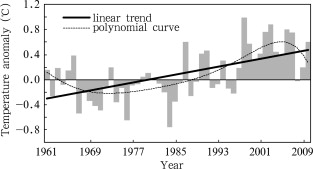
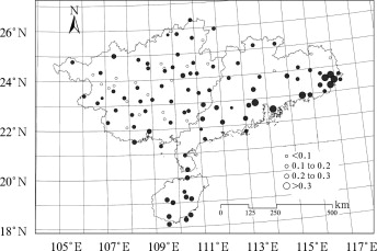
During 1961–2010, annual mean surface air temperatures in South China have increased with a significant trend of 0.16°C per decade (Fig. 1 ), and 80% stations (a total of 88 stations) are significant as well. The increasing rate in South China is lower than the national rate (0.23°C per decade) [ ECSCNARCC , 2011 ] within the same period of time, but much higher than the global rates (0.07°C per decade and 0.13°C per decade) over the past 100 and 50 years, respectively [ IPCC, 2007a ]. In the 1970s and 1980s, temperatures were below normal. Since the mid-1990s, temperatures had shown a significant upward trend. Different regions demonstrate different warming rates. Major warming regions are the Pearl River Delta and the northeastern coastal areas, with a warming rate of more than 0.30°C per decade. The secondary warming area is Hainan province (0.27°C per decade). Guangxi and northern Guangdong have the slowest change rate of 0.15°C per decade (Fig. 2 ). The mean temperatures in the four seasons all showed significant increasing trend, and the most distinguished upward trend occurred in winter, followed by autumn, spring and summer (Table 1 ).
|
|
|
Figure 1. Anomalies of annual mean surface air temperature in South China during 1961–2010 |
|
|
|
Figure 2. Spatial distribution of linear trends in annual mean temperature in South China during 1961–2010 (unit: °C per decade; shade denotes the trend significant at the 95% confidence level) |
| Item | Annual | Spring | Summer | Autumn | Winter |
|---|---|---|---|---|---|
| Mean temperature | 0.16* | 0.12* | 0.10* | 0.18* | 0.27* |
| Extreme maximum temperature | 0.22* | 0.30* | 0.05 | 0.04 | 0.15 |
| Extreme minimum temperature | 0.47* | 0.02 | 0.55* | 0.45 | 0.47* |
Note:
- . denotes the trend significant at the 95% confidence level
3.1.2. Extreme temperature
The regional mean annual extreme maximum and minimum temperatures in South China increase significantly at the rates of 0.22 and 0.47°C per decade, respectively (Table 1 ), which are higher than the national rates (0.12 and 0.28°C per decade), and are different from those in Northeast, Northwest, North and East China [ Jiang and Ding, 1999 , Ma, 1999 , Xie and Cao, 1996 , Ren et al., 2005 and Tang et al., 2005 ]. The increasing rate of extreme minimum temperature in South China is much higher than that of mean temperature. This indicates that increase of mean temperature is mainly contributed by the increase of extreme minimum temperature. Spatially, the extreme maximum temperature at 21 (19%) stations mainly in the central and northern Guangxi has an insignificant decreasing trend, while it shows a significant increasing trend at 38 stations plus another 51 stations with an insignificant increasing trend. The increasing trend is most distinguished (more than 0.50°C per decade) in the Pearl River Delta, the coastal areas of eastern Guangdong, and in northern Hainan. In contrast, the extreme minimum temperatures at all stations have an increasing trend, and 99 (90%) stations are significant. Similarly, the most distinguished increasing trend (more than 0.70°C per decade) is observed in the Pearl River Delta, the coastal areas of eastern Guangdong, and Hainan. The increase rate of extreme maximum temperature is significant only in spring, while the increase rate of extreme minimum temperature is significant in both summer and winter (Table 1 ).
3.1.3. High-temperature days and low-temperature days
The regional mean high-temperature days have a significant increasing trend (1.1 d per decade), and it increased much faster after 1998, when there were six years with high-temperature days over 20 (Fig. 3 a). It has an insignificant decreasing trend at 25 stations in northern Guangxi, while the other 85 stations have an increasing trend, with 50 significant stations (> 5.0 d per decade) in the Pearl River Delta, the west and east parts of Guangdong, and in northern Hainan (Fig. 4 a).
|
|
|
Figure 3. The number of (a) high-temperature days, and (b) low-temperature days in South China during 1961–2010 |
|
|
|
Figure 4. Spatial distribution of linear trends in (a) high-temperature days, and (b) low-temperature days during 1961–2010 (unit: d per decade; shade denotes the trend significant at the 95% confidence level) |
The regional mean low-temperature days has a significant decreasing trend (–1.3 d per decade), and it decreased much faster after the mid-1980s (Fig. 3 b). All stations except only one have a decreasing trend, and 77 (70%) stations are significant. It decreased more toward north with a rate of up to –5.0 d per decade (Fig. 4 b).
3.2. Precipitation
3.2.1. Precipitation totals
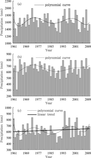
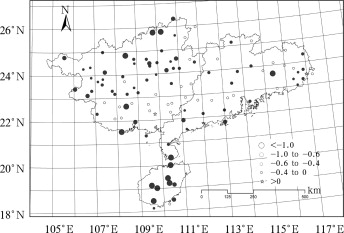
The regional mean annual precipitation totals have an insignificant increasing trend (10.9 mm per decade), which is consistent with the weak change trend found in Wang and Zhai [2008] . However, annual precipitation has a large decadal variation with a cyclic period of about 20 years. In the mid-1960s, 1980s and 2000s, annual rainfall was below normal; in the 1970s and mid-1990s, annual precipitation was above normal (Fig. 5 a). The rainfall during the first and second rainy seasons has an insignificant increasing trend, with increase rates of 2.4 and 9.9 mm per decade, respectively. Before 2000, the rainfall during the first and second rainy seasons has a similar change pattern. They were below normal in the 1960s and 1980s and above normal in the 1970s and 1990s. After 2000, the rainfall during the first rainy season was above normal, but it was below normal during the second rainy season (Fig. 5 b&5c). Geographically, there was no significant change trend for the annual, first and second rainy season rainfall at more than 95% stations.
|
|
|
Figure 5. Precipitation for (a) annual, (b) first rainy season, and (c) second rainy season in South China during 1961–2010 |
3.2.2. Rainy day
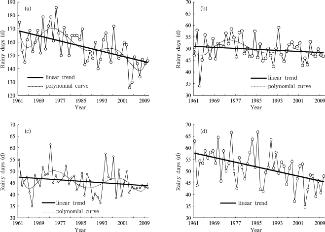
The regional mean annual rainy days has a significant decreasing trend (–4.8 d per decade). This is consistent with the national decreasing pattern over China [ Wang et al., 2006 ]. Annual rainy days have a similar change pattern with annual rainfall, being below normal in the 1960s, 1980s and after 2000, and above normal in the 1970s and 1990s (Fig. 6 a). Geographically, except for Pubei station in Guangxi, the annual rainy days at all other 109 stations have a decreasing trend, and 77 stations are significant. The decrease rate is up to –17.8 d per decade in northern Guangxi and in Hainan (Fig. 7 ). The rainy days during the first and second rainy seasons have an insignificant decreasing trend, at a rate of –0.5 d per decade and –0.7 d per decade, respectively (Fig. 6 b&6c). Thus, the decrease of rainy days mainly takes place in the non-rainy seasons. The rainy days in the non-rainy seasons has a significant decreasing trend of-4.8 d per decade (Fig. 6 d).
|
|
|
Figure 6. Rainy days in (a) annual, (b) first rainy season, (c) second rainy season, and (d) non-rainy season in South China during 1961–2010 |
|
|
|
Figure 7. Spatial distribution of linear trends in annual rainy days in South China during 1961–2010 (unit: d per decade; shade denotes the trend significant at the 95% confidence level) |
3.2.3. Rain intensity
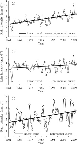
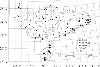
The regional mean annual rain intensity has a statistically significant increasing trend (Fig. 8 a), which is consistent with findings in a previous study [ Wang and Zhai, 2008 ]. With decreasing rainy days, the increase of total rainfall is the result of the increase of rain intensity. The annual rain intensity in the 1960s, 1970s and 1980s was below normal, whereas it was above normal since the 1990s. Except for the weak decreasing trend at Wuzhou, Linshan and Beiliu in Guangxi, the other 107 stations demonstrate an increasing trend, and 62 (58%) stations are statistically significant, especially in Hainan, eastern Guangdong and northern Guangxi, with a maximum of 1.1 mm d−1 per decade at Wuzhishan station in Hainan (Fig. 9 ). The rain intensity in the first rainy season does not show any significant change trend (0.2 mm d−1 per decade), but it increases faster after 2000 (Fig. 8 b). It shows a significant increasing trend (0.4 mm d−1 per decade) during the second rainy season (Fig. 8 c). The increase of rain intensity results in increase of heavy-rain events. Results show that both heavy-rain days and heavy-rain amount have an increasing trend, although it’s statistically insignificant.
|
|
|
Figure 8. Rain intensity in (a) annual, (b) first rainy season, and (c) second rainy season in South China during 1961–2010 |
|
|
|
Figure 9. Spatial distribution of linear trends in the annual rain intensity in South China during 1961–2010 (unit: mm d−1 per decade; shade denotes the trend significant at the 95% confidence level) |
3.3. Sunshine duration, haze and cloud cover
The regional mean sunshine duration has a significant decreasing trend (–40.9 h per decade), which is greater than the national decreasing trend (–37.6 h per decade) in the last 50 years [ Ren et al., 2005 ]. The sunshine duration at 11 stations has an increasing trend, but only 2 stations are significant. The sunshine duration at 99 (90%) stations shows a decreasing trend, and 64 stations are significant. It decreases dramatically at 3 stations, Shenzhen of Guangdong (–128.6 h per decade), Chenmai of Hainan (–128.5 h per decade), and Hengxian of Guangxi (–188.6 h per decade).
The regional mean hazy days increase significantly at 6.3 d per decade, and faster after the 1980s, particularly in the Pearl River Delta, which is closely associated with the fast development there [ Liu et al., 2004 ].
Except for areas in northern Guangxi and eastern Hainan where the total cloud has a significant decreasing trend, the total cloud in other areas has a significant increasing trend, particularly in the coastal areas of South China and western Hainan. Due to the canceling out effect of decrease and increase, the regional mean total cloud has a weak and statistically insignificant decreasing trend.
Results show that the regional mean sunshine duration and hazy days have an insignificant negative correlation. This negative correlation exists at 53 stations, and only 7 stations are significant. This suggests that the increase of hazy days is not the main reason for the decrease of sunshine duration.
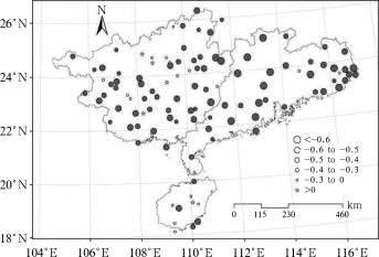
Meanwhile, the sunshine duration and total cloud have a significant negative correlation at 88 stations. This correlation is stronger in most areas of Guangdong and central-southern Guangxi (Fig. 10 ). This indicates that the decrease of sunshine duration in South China is mainly caused by the increase of total cloud, which is consistent with conclusions from other regions [ Du et al., 2007 , Zhang et al., 2006 and Zhang et al., 2003 ].
|
|
|
Figure 10. Distribution of correlation coefficients between annual sunshine duration and total cloud cover in South China during 1961–2010 (shade denotes the coefficient significant at the 95% confidence level) |
3.4. Pan evaporation and wind speed
The regional mean pan evaporation has a significant decreasing trend (–65.9 mm per decade), which is in agreement with the decreasing trend at the national scale in the last 50 years [ Ren and Guo, 2006 ] and in the Northern Hemisphere [ Peterson et al., 1995 , Chattopadhyay and Hulme, 1997 and Thomas, 2000 ]. The decrease rate in South China is larger than that for the entire China (–34.5 mm per decade), particularly in the southwest of Guangdong and southern Guangxi with a decrease rate of less than –100 mm per decade.
The regional mean wind speed has a significant decreasing trend (–0.11 ms−1 per decade). This is consistent with the national decreasing trend in the last 50 years [ Ren et al., 2005 ].
As an indicator of evaporation capability, the pan evaporation is affected by many factors, such as surface air temperature, solar radiation, wind speed, and so on. It is normally accepted that the increase of air temperature usually leads to increases of the evaporation, but in practice, the pan evaporation decreases with the increase of surface air temperature. This is called evaporation paradox. In order to identify the cause for the decrease of pan evaporation in South China, we analyze the relationship between pan evaporation and sunshine duration and wind speed. The regional mean pan evaporation in South China has a significant positive correlation (0.72) with the sunshine duration. Geographically, the correlation coefficients in northeastern Guangdong, southern and northern Guangxi, and southern Hainan are less than 0.3, but they are larger than 0.5 and statistically significant in other areas (Fig. 11 a). In general, areas with maximum decrease rate of sunshine duration are those where there are high correlation coefficients between sunshine duration and pan evaporation. Areas with small correlation coefficients also have little sunshine duration change. This indicates that the sunshine duration plays an important role in determining the pan evaporation change trend.
|
|
|
Figure 11. Correlation coefficients between pan evaporation and sunshine duration (a), and mean wind speed (b) during 1961–2010 (shade denotes the coefficient significant at the 95% confidence level) |
The regional mean annual pan evaporation has a significant positive correlation (0.79) with wind speed. There are higher correlation coefficients (> 0.5) in the central part of South China (Fig. 11 b). In areas with obvious decrease in pan evaporation, there are higher correlation coefficients. This suggests that wind speed play an important role in the decrease of pan evaporation. In summary, the decease of wind speed and sunshine duration together determines the decreasing trend of the pan evaporation in South China, which is in agreement with results in the lower reaches of the Yellow River Basin [ Ji et al., 2012 ].
3.5. Tropical cyclone
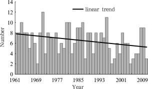
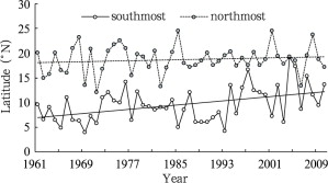
The number of landing tropical cyclones in South China has a weak decreasing trend (–0.6 per decade) during 1961–2010 (Fig. 12 ). This is in good agreement with the change trend of landfalls over the entire China [ Hu et al., 2008 ]. In spite of the decrease in tropical cyclones number, the intensity of landing tropical cyclones has a weak increasing trend. This is also in agreement with the trend of tropical cyclone intensities for the entire China [ Wang and Ren, 2008 ]. Both the southmost and northmost formation locations of the tropical cyclones landing in South China shifted toward north in the past half a century. Compared to 1961–1995, both the southmost and north-most locations during 1996–2010 shifted toward north 4.3°N and 0.6°N, respectively. Generally speaking, the generating source location has converged towards 10–19°N in recent years in South China (Fig. 13 ). During 1996–2010, the landing locations concentrated in areas between 18–24°N. The southmost landing locations shifted towards north at the rate of 0.14°N per decade, while the northmost landing locations did not show any trend, shifting back and forth in areas between 22–23.5°N. The first landing date shows a weak postponement trend (1.8 d per decade), and the last landing date shows a weak advance trend (3.6 d per decade), thus the typhoon season has a weak decreasing trend (–5.4 d per decade). This is also consistent with the national trend [ Ren et al., 2007 ].
|
|
|
Figure 12. The number of tropical cyclones landing in South China during 1961–2010 |
|
|
|
Figure 13. The southmost and northmost latitude of landfall tropical cyclones during 1961–2010 |
4. Conclusions and discussion
(1) During 1961–2010, the annual mean surface air temperature in South China has a significant increasing trend of 0.16°C per decade, which is lower than the national rate but higher than the global or Northern Hemispheric rates. The increase is more distinguished in winter and in the Pearl River Delta. The increase rate of the annual extreme minimum temperature (0.48°C per decade) is over twice that of the extreme maximum temperature (0.20°C per decade), and is larger than that of the mean temperature within the same period of time as well. The increase of the mean temperature in South China is mainly contributed by the increase of the extreme minimum temperature. Meanwhile, the extreme maximum temperature only shows a significant increasing trend in spring, and the extreme minimum temperature shows a significant increasing trend in both summer and winter. The increase rate of high-temperature days (1.1 d per decade) is close to the decrease rate of low-temperature days (–1.3 d per decade). The temperature increase in South China is mainly caused by the global warming, and is also affected by the fast development and urbanization in the region. Previous studies showed that the temperature increase due to urbanization has a considerable contribution to the regional increasing trend of temperature [ Ren et al., 2005 ]. However, further investigation is needed on how the urbanization affects the increase of regional mean temperature in South China. Meanwhile, it is certain that the increase rate will be reduced if stations in the urban areas are removed from the analysis.
(2) The total precipitation at the annual, first rainy and second rainy seasons does not show any significant change trend, but it does show some decadal variations. For instance, it is below normal in the 1960s, 1980s and 2000s, and is above normal in the 1970s and 1990s. The annual rainy days have a significant decreasing trend (–4.8 d per decade), but it does not show any significant change trend during the first rainy and second rainy seasons. This suggests that the decrease of annual rainy days only takes place during the non-rainy season. The annual and second rainy season rain intensity has a significant increasing trend of 0.44 and 0.39 mm d−1 per decade, respectively. It does not show any significant change trend during the first rainy season. The increase of rain intensity results in a weak increasing trend of heavy-rain days and amount.
(3) The regional mean sunshine duration has a significant decreasing trend of –40.9 h per decade, and the number of hazy days has a significant increasing trend of 6.3 d per decade. Neither variables show any significant correlation for the regional mean or at individual stations. The sunshine duration does show statistically significant negative correlation with total cloud at most stations. This suggests that the decrease of sunshine duration is mainly caused by the increase of total cloud in South China.
(4) Both the regional mean pan evaporation and wind speed have significant decreasing trends of –65.9 mm per decade and –0.11 m s−1 per decade, respectively. The decrease of both sunshine duration and mean wind speed plays an important role in the decrease of pan evaporation. As for the cause of the decrease in mean wind speed, it might be associated with fast urbanization and the decrease of cold high pressures, tropical cyclones and summer monsoons [ Ren et al., 2005 ].
(5) The number of landfall tropical cyclones has an insignificant decreasing trend of –0.6 per decade, and the landfall intensity has a weak increasing trend. The formation location of the tropical cyclones landing in South China has converged towards 10–19°N, and the landing position has shown a northward trend. The date of the first landfall tropical cyclone postpones 1.8 d per decade, and the date of the last landfall advances 3.6 d per decade, resulting in reduction of the typhoon season by 5.4 d per decade, particularly after the 1990s. The backward shift of the date of the first landfall might be related to the southward and westward shift of the subtropical high pressure in May [ Ren et al., 2007 ].
Acknowledgements
This study was supported by the Special Climate Change Research Program of China Meteorological Administration (No. CCSF-09-11, CCSF-09-03, CCSF201125, and CCSF201211), as well as the Science and Technology Planning Project of Guangdong province (No. 2011A030200021). Cordial thanks are extended to the editor and the anonymous reviewers for their professional comments and suggestions, which greatly improved the quality of this manuscript.
References
- Alexanderson, 1986 H. Alexanderson; A homogeneity test applied to precipitation data; J. Climatol., 6 (1986), pp. 661–675
- Chattopadhyay and Hulme, 1997 N. Chattopadhyay, M. Hulme; Evaporation and potential evapotranspiration in India under conditions of recent and future climate change; Agricultural and Forest Meteorology, 87 (1997), pp. 55–72
- Ding and Jiang, 1998 Y.-G. Ding, Z.-H. Jiang; Signal Processing for Meteorological Data Series (in Chinese)China Meteorological Press (1998), p. 285
- Du et al., 2007 J. Du, D. Bian, J. Hu, et al.; Climatic change of sunshine duration and its influencing factors over Tibet during the last 35 years; Acta Geographica Sinaca (in Chinese), 62 (5) (2007), pp. 492–500
- Du et al., 2004 Y.-D. Du, L.-L. Song, H.-Q. Mao, et al.; Climate warming in Guangdong province and its influences on agriculture and counter measures; Journal of Tropical Meteorology (in Chinese), 10 (2) (2004), pp. 150–159
- ECSCNARCC (Editorial Committee for Second China’s National Assessment Report on Climate Change, 2011 ECSCNARCC (Editorial Committee for Second China’s National Assessment Report on Climate Change; Second China’s National Assessment Report on Climate Change (in Chinese)Science Press (2011), p. 710
- Fu et al., 2003 C.-B. Fu, W.-J. Dong, G. Wen, et al.; Regional response and adaptation to global change; Acta Meteorologica Sinica (in Chinese), 61 (2) (2003), p. 245249
- GAQSIQPRA (General Administration of Quality Supervision, Inspection and Quarantine of the People’s Republic of China), and CNSMC (China National Standardization Management Committee, 2006 GAQSIQPRA (General Administration of Quality Supervision, Inspection and Quarantine of the People’s Republic of China), and CNSMC (China National Standardization Management Committee; State Standard of the People’s Republic of China (GB/T 19201-2006): Grade of Tropical Cyclones (in Chinese)China Standards Press (2006), p. 3
- Hu et al., 2008 Y.-M. Hu, L.-L. Song, A.-J. Liu, et al.; Analysis of the climatic features of landfall tropical cyclones in China during the past 58 years; Acta Scientiarum Naturalium Universitat Is Sunyatsena(in Chinese), 47 (5) (2008), pp. 115–121
- IPCC, 2007a IPCC; Climate Change 2007: The Physical Science Basic; Cambridge University Press, Contribution of Working Group I to the Fourth Assessment Report of the Intergovernmental Panel on Climate Change. Solomon S. D. et al. Eds. (2007) 996pp
- IPCC, 2007b IPCC; Climate Change 2007: Impacts; Cambridge University Press, Adaptation and Vulnerability. Contribution of Working Group II to the Fourth Assessment Report of the Intergovernmental Panel on Climate Change. Parry M. L. et al. Eds. (2007) 976pp
- Ji et al., 2012 X.-J. Ji, J.-J. Wang, W.-L. Gu, et al.; Trends in annual seasonal pan evaporation in the lower Yellow River Basin from 1961 to 2010; Adv. Clim. Change Res., 3 (4) (2012), pp. 195–204
- Jiang and Ding, 1999 Z.-H. Jiang, Y.-G. Ding; Renewed study on the warming process of Shanghai during the past 100 years; Journal of Applied Meteorology (in Chinese), 10 (2) (1999), pp. 151–159
- Liu et al., 2004 A.-J. Liu, Y.-D. Du, H.-Y. Wang; Climatic characteristics of haze in Guangzhou; Meteorology Monthly (in Chinese), 30 (12) (2004), pp. 68–71
- Ma, 1999 X.-B. Ma; The asymmetric change trend of maximum and minimum temperature in the Northwest China; Acta Meteorologica Sinica (in Chinese), 57 (5) (1999), pp. 613–621
- Peterson et al., 1995 T.C. Peterson, V.S. Golubev, P.Y. Groisman; Evaporation losing its strength; Nature, 377 (1995), pp. 687–688
- Ren et al., 2007 F.-M. Ren, X.-L. Wang, W.-J. Dong, et al.; Changes in the first-landfall and last-landfall tropical cyclones in China; Advances in Climate Change Research (in Chinese), 3 (4) (2007), pp. 224–228
- Ren and Guo, 2006 G.-Y. Ren, J. Guo; Change in pan evaporation and the influential factors over China: 1956–2000; Journal of Natural Resources (in Chinese), 21 (1) (2006), pp. 31–44
- Ren et al., 2005 G.-Y. Ren, J. Guo, M.-Z. Xu, et al.; Climate changes of China’s mainland over the past half century; Acta Meteorologica Sinica (in Chinese), 63 (6) (2005), pp. 942–956
- Tang et al., 2005 H.-Y. Tang, P.-M. Zhai, Z.-Y. Wang; Change in mean maximum temperature, minimum temperature and diurnal range in China during 1951–2002; Climate and Environmental Research (in Chinese), 10 (4) (2005), pp. 728–735
- Thomas, 2000 A. Thomas; Spatial and temporal characteristics of potential evapotranspiration trends over China; International Journal of Climatology, 20 (2000), pp. 381–396
- Wang et al., 2006 D.-J. Wang, L. Chen, Y.-G. Ding; The change trend in rainfall, wet days of China in recent 40 years and the correlation between the change trend and the change of global temperature.Journal of; Tropical Meteorology (in Chinese), 22 (3) (2006), pp. 283–289
- Wang and Ren, 2008 X.-L. Wang, F.-M. Ren; Variations in frequency and intensity of landfall tropical cyclones over China during 1951–2004; Marine Forecasts (in Chinese), 25 (1) (2008), pp. 65–73
- Wang and Zhai, 2008 X.-L. Wang, P.-M. Zhai; Changes in China’s precipitation in various categories during 1957–2004; Journal of Tropical Meteorology (in Chinese), 24 (5) (2008), pp. 459–466
- Wei, 2007 F.-Y. Wei; Modern Climatic Statistical Diagnosis and Prediction Technology (in Chinese) (3)China Meteorological Press (2007), p. 296
- Xie and Cao, 1996 Z. Xie, H.-X. Cao; The asymmetric trend of change in maximum and minimum temperature in Beijing; Acta Meteorologica Sinica (in Chinese), 54 (4) (1996), pp. 501–507
- Zhang et al., 2003 Y.-L. Zhang, B.-Q. Qin, W.-M. Chen, et al.; The analysis of variation characteristics of sunshine in the recent forty years in Wuxi region; Scientia Meteorologica Sinica (in Chinese), 23 (2) (2003), pp. 231–236
- Zhang et al., 2006 Z. Zhang, L. Lin, Y.-C. Sun, et al.; Analysis on climate change characteristics of sunshine duration in Yinchuan city; Arid Zone Research (in Chinese), 23 (2) (2006), pp. 344–348
Document information
Published on 15/05/17
Submitted on 15/05/17
Licence: Other
Share this document
Keywords
claim authorship
Are you one of the authors of this document?
