Abstract
Based on the 1961–1990 observed daily precipitation in the Changjiang-Huaihe River Basin, the NCEP/NCAR reanalysis data, and the HadCM3 model data for IPCC SRES A1B climate projections, the simulation capabilities of the BP-CCA downscaling approach for extreme precipitation indices of the current climate are assessed by applying canonical correlation analysis (CCA). In addition, future extreme precipitation indices in the middle and late 21st century are projected. The results show that simulation capability of the HadCM3 for regional climate characteristics can be effectively improved by the downscaling approach, with 30%–100% reduction of the relative errors of the climatological mean state of extreme precipitation indices. However, the downscaling results still show wetter winter and dryer summer than the observation. Under the SRES A1B emission scenario, frequency and intensity of extreme precipitation events are projected to increase, and the estimated increasing rate is higher for extreme precipitation indices than for mean precipitation index; and in summer than in winter. Extreme precipitations in the middle and late 21st century are expected to increase by 14% and 25% respectively in winter, and by 24% and 32% respectively in summer.
Keywords
canonical correlation analysis ; BP-CCA downscaling ; extreme precipitation ; projection
1. Introduction
In recent years, the change of extreme climate events under the background of global warming has attracted widespread attention. With the ongoing global warming, extreme climate events related to temperature have frequently occurred, at the same time, the warming induced water cycle variations have led to increases in severe precipitation and extreme precipitation events [ Trenberth et al., 2003 ]. Located in the transition area from the subtropical zone to the warm midlatitudes, the Changjiang-Huaihe River Basin of China is highly sensitive to regional climate changes. To carry out simulation and projection of regional climate changes in this area under the background of global warming, it bears important scientific significance and practical importance in strengthening abilities of preparation for and reduction of hazards and in search of strategies and measures for climate change mitigation.
It is well known that global climate model (GCM) is an indispensable tool to perform research in simulation and projection of large scale climate changes. However, since the spatial resolutions are normally low, it is hard to directly obtain detailed regional climate change characteristics from a GCM. Currently, there are mainly two methods to overcome this shortcoming: dynamical downscaling method [ Washington et al., 2000 ; Wang et al., 1992] and statistical downscaling method [ Fuentes and Heimann, 2000 ]. Compared with dynamical downscaling method, statistical downscaling method performs less computation and requires less computing power and has greater flexibility in choosing research area and in implementing the model. Thus, the statistical downscaling method has been widely used outside China in the study of regional climate simulation and projection [ Dibike et al., 2008 and Sailor and Li, 1999 ; Busuioc et al., 2001 ]. In China, Fan et al. [2007] used a multiple linear regression model which is a combination of principal component analysis and stepwise regression to study the future regional temperature variations in northern China. Their results showed that downscaling statistical model can improve the simulation capability of a GCM for regional climate characteristics. Using a multiple linear regression based statistical downscaling method and the Delta methods, Zhao and Xu [2007] performed comparative analysis of climate projection in the source region of the Yellow River. Although there are some published researches of statistical downscaling and extreme climate [ Chen et al., 2010 and Jiang et al., 2007 ], application of statistical downscaling method in regional extreme climate research is still in deficiency.
As a well behaved method for short-term climate analysis and forecast [ Barnett and Preisendorfer, 1987 ], canonical correlation analysis (CCA) was applied to forecast the U.S. summer precipitation by Barnston in 1996. It was implemented as the U.S. National Oceanic and Atmospheric Administration (NOAA) operational forecast model for three-month total precipitations [ Barnston and Smith , 1996 ]. Its forecast skills were very close to those of the coupled ocean-atmosphere model at National Centers for Environmental Prediction (NCEP). Moreover, for years the forecast skills of CCA have been leading other operational statistical models. In recent years, CCA method has been applied to statistical downscaling models [ Willem and Warren, 2000 and Chen and Chen, 2003 ], which has yielded very good results. Tomozeiu et al. [2006] adopted this approach in studying extreme temperature and precipitation in the area of Rome, Italy. Their results showed that CCA method did a very good job in simulating extreme temperature index under current climate conditions, and the error was less than 0.8°C in the simulation of winter maximum and minimum temperatures.
In this paper, we use the CCA statistical downscaling method combined with NCEP/NCAR (National Center for Atmospheric Research, U.S.) reanalysis data and the projections of HadCM3 model under the IPCC SRES A1B emission scenario to simulate winter and summer season extreme precipitation indices at 26 stations in the Changjiang-Huaihe River Basin. We will assess the capability of the method in simulating current climate and apply it to project the regional extreme precipitation variability in this region in the middle and late 21st century.
2. Data and methodology
2.1. Data
We use daily observed precipitation data during 1961–1990 at 26 stations in the Changjiang-Huaihe River Basin. We also employ the monthly mean NCEP/NCAR reanalysis data which have a spatial resolution of the 2.5°×2.5° to construct the statistical downscaling model. The GCM model data are from the HadCM3 of the Hadley Center, which have a horizontal resolution of 3.75°×2.5°, including daily precipitation, monthly sea surface pressure, temperature at 850 hPa and specific humidity at 1000–700 hPa, as well as the experimental projection data for the middle (2020–2049) and late (2070–2099) periods of the 21st century under the IPCC SRES A1B emission scenario. Prior to building the model, HadCM3 data were interpolated to the same grid as the NCEP data by using the bilinear interpolation method. In order to eliminate systemic bias, all variables are standardized by their current climate mean state of 1961–1990.
We choose three extreme precipitation indices, which have low noise level and high significance level. They are average daily precipitation intensity (SDII), consecutive 5-day maximum precipitation (R5d), and extreme precipitation contribution rate (R95t). The detailed definitions of these indices are contained by Frich et al. [2002] .
2.2. Methodology
Our statistical downscaling method adopts an approach that applies CCA to the filtered fields by empirical orthogonal function (EOF) analysis. We refer to this method as BP-CCA. Specifically, the variables will be analyzed by EOF and the first few modes are chosen to undergo CCA analyses. As a result, a statistical relationship between large scale variables and regional climate indices will be established [ Benestad , 2004 ]. When this statistical model is applied to the situation where large scale variables are the results of the projections of future climate scenario, the variance enlargement technique [ von Storch, 1999 ] is used to manually correct the estimation. This is because the variances generated by statistical downscaling models are usually lower than the real variances [ Dibike et al., 2008 ]. We will use the inverse of the standard deviation based on the 1961–1990 estimation to enlarge the variances of the downscaling model.
In the studies of statistical downscaling simulations, the principal choice of large scale variables is related to global circulation and temperature [ Ruping and David, 2002 , Linderson et al., 2004 and Hellstrom et al., 2001 ]. This is because these variables can be accurately simulated by the GCM and their impacts on surface climate are also significant. Consequently, in this study, temperature at 850 hPa in the region 20°–40°N, 110°–125°E is chosen as large scale variable for winter extreme precipitation index. For summer extreme precipitation index, the large scale variable is the combined field (denoted as SLP+S) of sea level pressure (SLP) in the region of 15°–45°N, 95°–135°E, and the average specific humidity (S) within 1000–700 hPa in the region of 10°–30°N, 110°–125°E.
3. Downscaling simulation of current climate
Before performing projection with the downscaling model, it is necessary to evaluate its simulating ability of current climate. We applied the BP-CCA downscaling model in the simulated current climate of the HadCM3 and produced winter and summer extreme precipitation indices during 1961–1990 in the Changjiang-Huaihe River Basin. We further compared the BP-CCA downscaling results with the extreme precipitation indices from daily precipitation of the HadCM3 to evaluate the downscaling model simulation capability of regional climate.
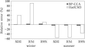
Figure 1 presents the simulated relative errors of averaged extreme precipitation indices over the Changjiang-Huaihe River Basin. It can be seen that the downscaling model markedly enhances the simulation capability of the regional extreme precipitation indices. For instance, for simulations with HadCM3, the relative error of the simulated winter R5d is as high as 90%; the simulated winter R95t is better with a relative error around 10%. As a result of applying downscaling model, all relative errors of simulated extreme precipitation indices are reduced to within 5%. For winter, the relative errors for the simulated three extreme precipitation indices are 0.6% (SDII), 3.1% (R5d), and 3.8% (R95t). For summer, they are −3.1% (SDII), −2.5% (R5d), and −4.2% (R95t). Compared with HadCM3, these relative errors are decreased by 30% to 80%. Therefore, with the application of the downscaling model, the simulations are much closer to the observation.
|
|
|
Figure 1. Simulated relative errors (%) of area-averaged extreme precipitation indices over the Changjiang-Huaihe River Basin for the period 1961–1990
|
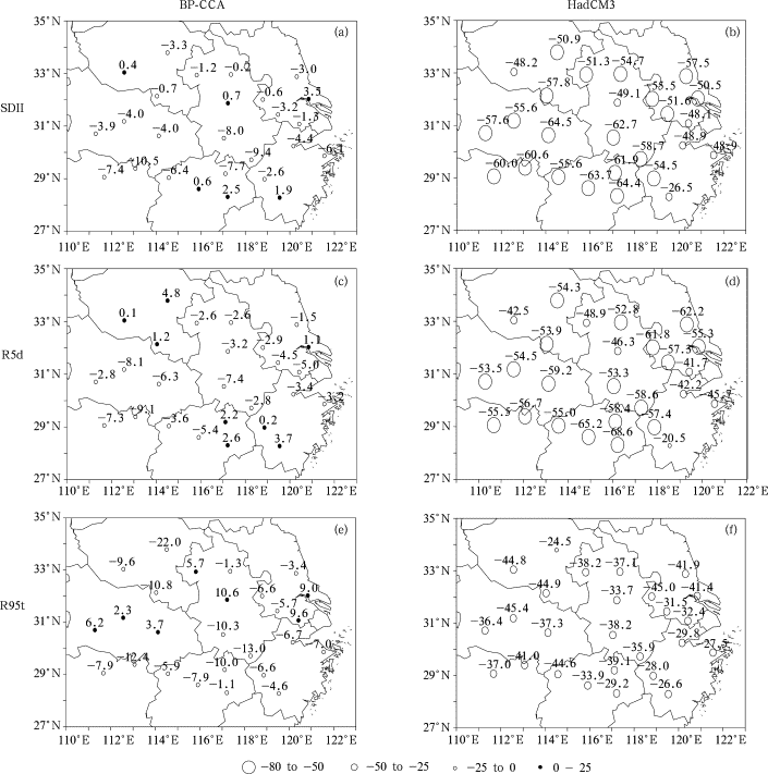
Figure 2 displays the spatial distribution of the relative errors of the simulated summer extreme precipitation indices by HadCM3 and the downscaling model. For the convenience of comparison, the HadCM3 simulation result is interpolated onto the stations. It can be seen that HadCM3 simulated summer extreme precipitation indices over the Changjiang-Huaihe River Basin exhibit dry bias. For winter, there is a wet bias [ Jiang et al., 2009 ]. Furthermore, the winter simulation is markedly poorer than the summer simulation, and the simulation of R95t is better than R5d and SDII. Specifically, the relative errors of summer R95t simulation are around −30%; whereas, over the majority of the stations, the relative errors of R5d and SDII are beyond −50%. With the application of the downscaling model, the simulation capability of extreme precipitation indices under current climate is greatly enhanced. The relative errors of both winter and summer extreme precipitation indices over all the stations are decreased to within 10%. For instance, compared with the simulations without downscaling, the relative errors of winter SDII, R5d, and R95t simulations have decreased by 42%, 110%, and 9%, respectively; and the summer reductions are 52%, 51%, and 32%, respectively. In addition, the downscaling simulation capabilities for SDII and R5d are apparently better than that for R95t. For example, the averaged relative error over 26 stations for winter SDII is 0.3% as opposed to 2.1% and 3.5% respectively for R5d and R95t.
|
|
|
Figure 2. Spatial distributions of the percentage deviations (%) of summer extreme precipitation indices SDII, R5d, R95t simulated by the BP-CCA downscaling model (a, c, e, respectively), and the HadCM3 model (b, d, f, respectively)
|
Also, downscaling model reduced the root mean square error (RMSE) of extreme precipitation indices over all the stations. For winter R5d, the RMSEs of HadCM3 simulation are between 40 mm and 90 mm with an average of 54 mm. After the application of downscaling model, the RMSE for most of the stations are less than 30 mm, and the average is reduced to 21 mm, with a reduction of 30 mm. To summarize, the application of the BP-CCA downscaling model to the GCM can effectively improve the simulation capability of the HadCM3 for regional climate characteristics. Our results showed that it is feasible to use the HadCM3 data combined with the BP-CCA downscaling model to project the future regional climate.
4. Projections of future extreme precipitation
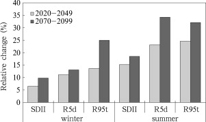
Based on the aforementioned BP-CCA downscaling model, the output data of the HadCM3 simulation under the SRES A1B emission scenario were used to project the future extreme precipitation over the stations in the Changjiang-Huaihe River Basin. Figure 3 shows the area-averaged relative change of the extreme precipitation over the Changjiang-Huaihe River Basin under the A1B emission scenario. It can be seen that over the middle and late 21st century, the area-averaged extreme precipitation indices show consistent trends of increase and the magnitudes in the late 21st century are greater than those in the middle of the 21st century. The change in summer is greater than in winter. The increase rates for extreme precipitation indices (R95t and R5d) are higher than that for the mean precipitation index (SDII). For example, in summer, R95t will increase 24% and 32% by the middle and late 21st century, respectively; R5d will increase 22% and 32%, respectively; and SDII will increase 15% and 18%, respectively.
|
|
|
Figure 3. Change (%) of area-averaged extreme precipitation indices over the Changjiang-Huaihe River Basin for the periods 2020–2049 and 2070–2099, relative to 1961–1990, projected by BP-CCA downscaling to the output data of the HadCM3 model under the SRES A1B scenario
|
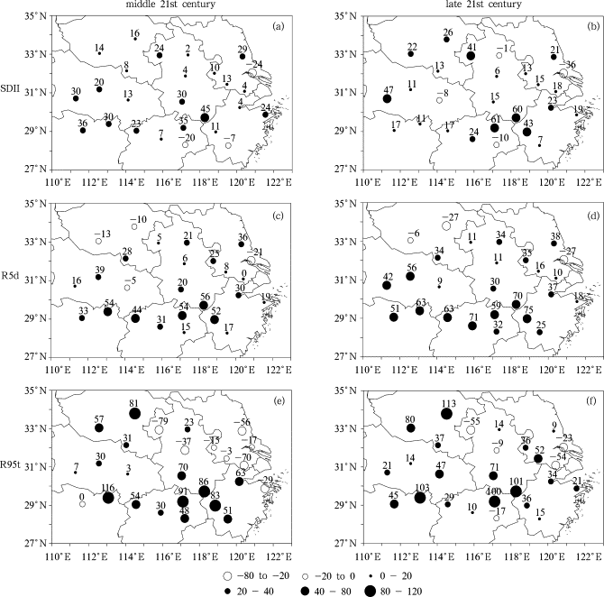
Figure 4 shows the spatial distribution of changes in summer extreme precipitation indices over the Changjiang-Huaihe River Basin in the middle and late 21st century. It can be seen that under the A1B emission scenario, changes in summer extreme precipitation vary in large extent by stations. For instance, in the middle 21st century, the average increase for R5d is 22%, and the most significant increasing area is located south of 30°N with the maximum increase of 75% (Quzhou station) in the late 21st century. Decreasing trend for R95t, is seen in the Changjiang Delta area, whereas there is an obvious increasing trend at the border of Zhejiang, Anhui, and Jiangxi provinces with changes greater than 50%. In the middle and late 21st century, the regional-averaged increases for R95t will be 24% and 32%, respectively; the increases for SDII will be 15% and 18%, respectively.
|
|
|
Figure 4. Changes (%) of summer extreme precipitation indices SDII, R5d, R95t in the middle (a, c, e, respectively), and late (b, d, f, respectively) 21st century, relative to the simulated current (1961–1990), projected by BP-CCA downscaling to the output data of the HadCM3 model under the SRES A1B scenario
|
Winter extreme precipitation indices show a consistent increasing trend and the magnitude of the increase in the late 21st century will be greater than that in the middle 21st century. For example, in the middle 21st century the average increase for SDII will be 7%, while it will be 11% in the late 21st century, and the most significant area will be the northwest of the Changjiang-Huaihe River Basin with the rate as high as 51% (Fuyang station). For R5d, the increase will be 11% and 13%, respectively in the middle and late 21st century, and the magnitude of the increase in the north will be higher than that in the south with the maximum of 20% (Xinyang station). For R95t, the increase will be 14% and 25% respectively in the middle and late 21st century. In the late 21st century, with the exception of some stations (Yueyang and Changde stations, for example) in the southwest of the region, the increase will be over 30% at most of the stations in the basin.
It is evident that for all the extreme precipitation indices the increase in summer will be slightly larger than that in winter. In the late 21st century, for example, the increase for summer SDII will be 7% higher than for winter, and 19% and 7% higher for R5d and R95t, respectively. In addition, the increases of extreme precipitation indices (R5d and R95t) are markedly greater than that of the mean precipitation index (SDII). In the late 21st century, the average summer increases of R5d and R95t are 14% higher than that of SDII. For example, at Nanjing station the increase of summer SDII in the late 21st century will be 13%, whereas the R5d increase will be 35% which is more than double of the SDII. This implies that the extreme precipitation will be more frequent and more intensive [ Meehl et al., 2005 ].
To summarize, the results of the BP-CCA downscaling model have shown that under the SRES A1B scenario future summer and winter extreme precipitations in the Changjiang-Huaihe River Basin will occur more frequently. Precipitations at the majority of the stations have increasing trends. The magnitudes of the increases for extreme precipitation indices will be noticeably higher than those for the mean precipitation index. The increase in the late 21st century will be higher than in the middle 21st century. Increase in summer will be slightly higher than in winter.
5. Conclusions and discussion
The study presented in this paper has arrived at the following conclusions.
(1) The BP-CCA downscaling method can significantly enhance the HadCM3 simulation capability of extreme precipitation indices in the Changjiang-Huaihe River Basin. The relative errors of the simulated climate means have decreased by 30% to 100%. The relative error at every station has decreased to within 10%. The simulations of SDII and R5d are better than that of R95t. However, the wet bias for winter and dry bias for summer still exist in the downscaling simulations. Nevertheless, downscaling has greatly reduced the RMSE of the extreme precipitation indices, and has markedly improved HadCM3 simulation capability of regional climate characteristics.
(2) Under the SRES A1B scenario, extreme precipitation in the Changjiang-Huaihe River Basin will occur more frequently. The increase in extreme precipitation will be greatly higher than that of the mean precipitation. The increase in summer will be slightly higher than in winter. While in the middle 21st century, area-averaged increases of winter SDII, R5d, and R95t will be 7%, 11%, and 14%, respectively, and 15%, 22%, and 24% in summer. In the late 21st century, area-averaged increases of winter SDII, R5d, and R95t will be 11%, 13%, and 25%, respectively, and 18%, 32%, and 32% in summer, which are all higher than the corresponding changes in the middle 21st century.
Although our results presented in the paper indicate that BP-CCA downscaling can greatly improve the HadCM3 simulation capability of regional climate and it can noticeably reduce the relative errors of extreme precipitation indices, the following factors contribute to the uncertainties in extreme precipitation projections. First, extreme precipitation events are mainly caused by small and mesoscale weather processes, whereas the downscaling technique only uses large scale variables thus cannot effectively represent small and mesoscale features. Second, extreme precipitation events are not only related to air circulation, but also impacted by topography, underlying features and other factors. Third, the choice of large scale variables and the geographical region is likely to determine the output of the downscaling model. Therefore, to reduce the uncertainties in applications of GCM and statistical downscaling models, future studies are needed in choosing different set of large scale variables and including information related to small and mesoscale processes, as well as in using different coupled GCMs.
Acknowledgements
This paper is supported by the National Natural Science Foundation (No. 40875058), and the National Key Basic Research Program (No. 2012CB955200) of China, and is funded by the Priority Academic Program Development (PAPD) of Jiangsu Higher Edusation Institutions.
References
- Barnett and Preisendorfer, 1987 T.P. Barnett, R. Preisendorfer; Origins and levels of monthly and seasonal forecast skill for United States surface air temperature determined by canonical correlation analysis; Monthly Weather Review, 115 (9) (1987), pp. 1825–1847
- Barnston et al., 1996 A.G. Barnston, T.M. Smith, T.M. Smith; Specification and prediction of global surface temperature and precipitation from global SST using CCA; J. Climate, 9 (1996), pp. 2661–2697
- Benestad, 2004 R.E. Benestad; Empirical-statistical downscaling in climate modeling; EOS, 85 (42) (2004), p. 417
- Busuioc et al., 2001 A. Busuioc, D.-L. Chen, C. Hellstrom; Performance of statistical downscaling models in GCM validation and regional climate change estimate: Application for Swedish precipitation; Int. J. Climatol, 21 (2001), pp. 557–578
- Chen and Chen, 2003 D.-L. Chen, Y.-M. Chen; Association between winter temperature in China and upper air circulation over East Asia revealed by canonical correlation analysis; Global and Planetary Change, 37 (2003), pp. 315–325
- Chen et al., 2010 Z.-H. Chen, H. Xiang, R. Gao; Trends of ten main extreme weather indices in Wuhan; Advances in Climate Change Research (in Chinese), 6 (1) (2010), pp. 22–28
- Dibike et al., 2008 Y.B. Dibike, P. Gachon, A. St-Hilaire, et al.; Uncertainty analysis of statistically downscaled temperature and precipitation regimes in northern Canada; Theoretical and Applied Climatology, 91 (2008), pp. 149–170
- Fan et al., 2007 L.-J. Fan, C.-B. Fu, D.-L. Chen; Estimation of local temperature change scenarios in North China using statistical downscaling method; Chinese Journal of Atmospheric Sciences (in Chinese), 31 (5) (2007), pp. 887–897
- Frich et al., 2002 P. Frich, L.V. Alexander, P. Della-Marta, et al.; Observed coherent changes in climatic extremes during the second half of the twentieth century; Climate Research, 19 (2002), pp. 193–212
- Fuentes and Heimann, 2000 U. Fuentes, D. Heimann; An improved statistical-dynamical downscaling scheme and its application to Alpine precipitation climatology; Theoretical Appllicaton Climatology, 65 (2000), pp. 119–135
- Hellstrom et al., 2001 C. Hellstrom, D.-L. Chen, C. Achberger, et al.; Comparison of climate change scenarios for Sweden based on statistical and dynamical downscaling of monthly precipitation; Climate Research, 19 (2001), pp. 45–55
- Jiang et al., 2007 Z.-H. Jiang, Y.-G. Ding, W.-L. Chen; Projection of precipitation extremes for the 21st century over China; Advances in Climate Change Research (in Chinese), 3 (4) (2007), pp. 202–207
- Jiang et al., 2009 Z.-H. Jiang, W.-L. Chen, J. Song, et al.; Projection and evaluation of the precipitation extremes indices over China based on seven IPCC AR4 coupled climate models; Chinese Journal of Atmospheric Sciences (in Chinese), 33 (1) (2009), pp. 109–120
- Linderson et al., 2004 M.L. Linderson, C. Achberger, D.-L. Chen; Statistical downscaling and scenario construction of precipitation in Scania, southern Sweden; Nordic Hydrology, 35 (2004), pp. 261–278
- Meehl et al., 2005 G.A. Meehl, J.M. Arblaster, C. Tebaldi; Understanding future patterns of increased precipitation intensity in climate model simulations; Geophys. Res. Lett, 32 (L18719) (2005) http://dx.doi.org/10.1029/2005GL023680
- Ruping and David, 2002 M. Ruping, M.S. David; Statistical-dynamical seasonal prediction based on principal component regression of GCM ensemble integrations; Monthly Weather Review, 130 (9) (2002), pp. 2167–2187
- Sailor and Li, 1999 D.J. Sailor, X. Li; A semiempiral downscaling approach for predicting regional temperature impacts associated with climatic change; J. Climate, 12 (1999), pp. 103–114
- Tomozeiu et al., 2006 R. Tomozeiu, C. Cacciamani, V. Pavan, et al.; Climate change scenarios for surface temperature in Emilia-Romagna (Italy) obtained using statistical downscaling models; Theoretical and Applied Climatology, 90 (2006), pp. 25–47
- Trenberth et al., 2003 K.E. Trenberth, A.-G. Dai, R.M. Rasmussen, et al.; The changing character of precipitation; Bull. Amer. Meteor. Soc, 84 (2003), pp. 1205–1217
- von Storch, 1999 H. von Storch; On the use of “inflation” in statistical downscaling; J. Climate, 12 (12) (1999), pp. 3505–3506
- Wang et al., 1993 H. Wang, Q. Cun, X. Zhang; The numerical simulation of the climatic change caused by CO2 doubling ; Science in China Series B , 4 (1993), pp. 451–462
- Washington et al., 2000 W.M. Washington, J.W. Weatherly, G.A. Meehl, et al.; Parallel climate model (PCM) control and transient simulations; Climate Dynamics, 16 (2000), pp. 755–774
- Willem and Warren, 2000 A.L. Willem, J.T. Warren; Statistical downscaling of monthly forecast; Int. J. Climatol, 20 (2000), pp. 1521–1532
- Zhao and Xu, 2007 F.-F. Zhao, Z.-X. Xu; Comparative analysis on downscaled climate scenarios for headwater catchment of Yellow River using SDS and Delta methods; Acta Meteorologica Sinica (in Chinese), 24 (4) (2007), pp. 653–662
Document information
Published on 15/05/17
Submitted on 15/05/17
Licence: Other
Share this document
claim authorship
Are you one of the authors of this document?


