Abstract
Urban fringe area is the most important space for city development. It includes several complicated elements, such as population, space, and management organization. On the basis of local population attributes in the city fringe area combined with people’s movement characteristics in time and space, this article reclassifies basic public service facilities and discusses the relationship between facility layout and housing, employment, and commuter transportation. Through a questionnaire survey in Qiaobei District of the urban fringe area in Nanjing and on the basis of comparative analysis, we discuss the impact factor on the choice of housing, urban services, and the tolerance of commuting time. Our findings indicate mutual promoting and restricting connections among living, employment, and services. Workers’ living situation determines their daily behavior, such as dining, shopping, and entertainment. Furthermore, different income levels have a great influence on residents’ choices with regard to places to live and develop their careers.
Keywords
Urban fringe area ; Employment ; Housing and services ; China
1. Introduction
Triggered by the unprecedented growth in urban populations and economies, Chinese cities have been rapidly expanding since the 1980s. As the main driving forces, local governments have great incentives for urban expansion because city revenue can be supplemented by the sales of rural lands appropriated in urban peripheral areas (Zhang, 2000 ). As a result, virtually all Chinese cities, especially large cities, have entered the fast track of urbanization and sprawl. From 2007 to 2011, urban buildup areas increased by 13.7% in Nanjing, 20.2% in Hangzhou, and 26.9% in Guangzhou (China State Statistical Bureau, 2012 ). While the speed of development is astonishing, concerns have been raised with regard to the quality of development and the provision of public services and facilities in these fast-changing urban fringe areas (Pan et al., 2009 ).
In China, urban fringe is usually viewed as areas loaded with conflicts of interest not only because they accommodate people with a variety of social-demographic backgrounds but also because most conflicts that arise from the urban planning and development process occur in these areas. For example, urban fringes are usually severely afflicted by demolition and relocation. Conflicting land uses, such as residential and industrial, can often be seen positioned next to each other in urban fringes because of improper planning decisions. Most urban fringe land is sold to real estate developers. Therefore, tomorrow’s urban fringe landscape is, to a large degree, dependent on the decisions of these developers, whose primary goal is profit maximization. As a result, more sustainable plans, such as transit-oriented mixed-use plans, are set aside in favor of large residential superblocks, and public services and necessary urban facilities are shortchanged in the process of development (Peng and Zhu, 2007 ).
The sustainable growth of newly developed urban areas relies on retaining and attracting people and establishments. Cities can sustain further growth and expansion only when the needs of urban fringe residents are addressed by municipal governments and developers. This paper presents an effort to understand the status and needs of the residents who live in urban fringe areas on the basis of their daily activities, location choices, and use of urban services and facilities. With the use of data collected from a survey in the new Qiaobei district of the city of Nanjing, we investigate the factors that influence the daily lives and location choices of various subgroups of residents who live or work in the urban fringe.
2. Related work
Over the past few decades, sustained interest has been focused on investigating the relationships between urban growth and public service provision. Research is generally focused on whether the cost effectiveness of urban services can be sustained in low-density, discontinued urban sprawl (Nelson and Duncan, 1995 ; Hortas-Rico and Solé-Ollé, 2010 ). Most research have focused on cities in Western countries. Therefore, existing research may have limited implications for Chinese cities because of differences in socio-political contexts and growth patterns. In addition, less attention has been drawn to the lives or the challenges faced by people who are living or working in newly developed areas.
As a result of rapid urban expansion, city fringe areas have become an important part of city space in China. An investigation into residents’ living, employment and service in this region not only further deepens the research about urban space but also improves the supply method of public service facilities.
Given the abovementioned reasons, we first reviewed the previous research efforts on three topics of interest: urban expansion of Chinese cities, the effect of urban environments on human activities, and research on urban space from the humanistic perspective.
2.1. Urban expansion of Chinese cities
As urbanization progresses, the population increases in almost all Chinese cities. Population growth in large cities usually does not increase the population density of high-density areas, but it promotes densification of less-developed areas, thereby causing expansion in the urban fringe. In particular, population densities in the most central zones frequently decline as households are displaced by the expansion of other activities, such as services and retail.
Although a lack of comprehensive public service facilities always exists in the city fringe, buyers׳ interest in this region seldom declines. This area gives people the opportunity to purchase housing at a relatively low price. People prefer a long daily commute rather than spend a lot of money on a house in the main city, which is more convenient.
The appearance of the city fringe is affected by the expansion of the city. Different expansion methods lead to different types of city fringes, which affect the living and working behavior of residents.
By comparing the land use/cover data in a different time period, the 1930s, Xiao et al. (2006) categorized the spatial expansion of a city into three types that correspond to three growth periods in contemporary Chinese history (normal growth type, i.e., the urban expansion caused by economic development and population growth over the past two decades).
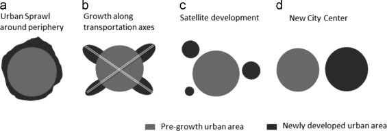
They also discussed three types of urban expansion observed in Chinese cities: expansion along radial corridors, expansion restricted by geomorphologic factors, and areal expansion in the fringes of urbanized territory (Figure 1 ). The first type of expansion usually occurs in cities, such as Beijing, with a good transportation infrastructure, such as a subway network. The second type of expansion can be observed in cities such as Shenzhen and Chongqing, whose expansion is restricted by geometry and topology. The third type of expansion can be found in many medium and small cities, such as Shijiazhuang and Changsha, where daily trips mainly rely on buses or bicycles. These types of expansion are not mutually exclusive, and all may be observed in one city.
|
|
|
Figure 1. Main types of urban growth patterns of Chinese cities. |
In many cities, efforts have been made to build a new part of a city or satellite cities as opposed to redeveloping the old part of a city. This type of growth relocates not only residents but also businesses, government agencies, schools, and jobs. Even if the expansion is for residential purposes, the preference for large-lot, single-family housing in U.S. cities appears to be rare. Instead, high-density, superblock types of apartments and condominiums are more common, especially in large cities.
In recent years, Nanjing, where the author lives, has been constructing a significant number of large residential districts in the urban fringe area. These districts not only house a large number of newly employed young people, but also include many resettlement housing. People who live in these new urban spaces behave quite differently from those who live in the main city.
2.2. Housing, Job, and activity choices
As stated above, urban spatial change affects travel demand by changing the spatial distribution of housing and job opportunities. Urban growth leads to decentralization of both housing locations and job opportunities. These changes have profound implications on public transportation services because the coverage area of these services needs to be increased. To maintain the quality of service, transit systems would inevitably become more costly (Meyer et al., 1965 ).
However, whether urban growth results in increased travel demand and commuting time remains inconclusive. Empirical studies have shown that urban commuting time has remained stable or increased only slightly during the past three of four decades despite continuous population growth and increases in commuting distance and congestion. One theory to explain this puzzle is the colocation hypothesis, which incorporates the belief that workers are’rational׳ actors and that they can adjust their workplace and housing locations in a free market system to optimize commuting costs (Gordon et al ., 1989b ; Levinson and Kumar, 1994 ). Compact land development in the urban fringe, which is characterized by high density and a high level of self-contained development, has been found to reduce the need to commute to the central city area and shorten the commuting distance (e.g. Cervero, 1995 ; Kenworthy and Laube, 1999 ; Kockelman, 1997 ; Levinson and Kumar, 1994 ; Schwanen et al., 2004 ).
Furthermore, polycentric development is often believed to constrain or reduce the growth of commuting distances in the urban expansion process. Gordon et al. (1989a) argued that decentralized employment centers tend to shorten overall commuting trip length. A similar finding was reported by Cervero and Wu (1998) , who found that employees who live in suburban centers in the San Francisco Bay Area have shorter commuting trips than those who reside in large and denser urban centers. However, some research has concluded that monocentric metropolitan areas have shorter commuting distances than polycentric metropolitan areas do (e.g., van de Coevering and Schwanen, 2006 ).
By using household travel surveys for the Washington, DC metropolitan region conducted in 1968 and 1988, Levinson and Kumar (1994) showed that commute time remained stable despite an increase in average commute distance. They concluded that, during the period of rapid suburban growth in the region, people periodically relocated their workplaces and residences to optimize their commute time. They define rational locator as a worker who follows the colocation process. Cervero and Wu (1998) analyzed the relationships between employment decentralization and commute distance and time in the San Francisco Bay Area, where employment has grown rapidly since 1980. Between 1980 and 1990, this trend led to a substantial increase in average commute distance and time. This finding contrasts with the colocation hypothesis that employment decentralization results in a shorter commute time.
2.3. Research on urban space from the humanistic perspective
In the modern urban planning development process, the concept of “people oriented” is always running through the entire process of urban development and planning evolution. The Athens charter pointed out that people’s need is the key to success in all construction work for workers engaged in urban planning. The Machu Picchu charter proposed that human interaction and communication is the fundamental of cities. Urban planning must be based on continuous collaboration among professional designers, residents, the public, and political leaders. The principle of “people oriented” in urban planning includes comprehensive demand of citizens, effective participation of citizens, developing people’s subjective initiative, and improving people’s quality of life.
Urban space research from the perspective of individual or family mainly refers to urban social living space and generally indicates micro-location research on residents’ living areas. The main contents of urban space research include businesses space, leisure place, and open space, and entertainment space. Studies in this field mainly focus on three aspects, namely, living, service, and employment space, and also focuses on related analysis of commuting.
Currently, studies on residential space tend to focus on the physical and social structure of a city, housing location choice, and social–spatial differentiation. Studies on working spaces mainly revolve around economic geography, location theory, and spatial distribution of industries. Studies that target urban service space usually look into the spatial distribution of urban retail and commercial establishments, and urban public service structure, among others. Studies of the relationship between residential space and working space are mostly approached from the perspective of job–housing balance or mismatch. The relationship between residential space and urban service space is generally considered based on social–spatial differences at the neighborhood level.
In the field of commute research, activity-based research usually accounts for individuals’ or households’ third location choices after the home and the workplace. A few large-scale urban models simulate individuals’ choices of employment, housing, and daily service destinations, which include the correlation between three types of spaces sequentially.
However, most of such studies are based on data that were not collected specifically for urban space research. Observed information, such as destinations from travel surveys, is not likely to reveal residents’ real attitudes or preferences toward urban spaces. In addition, urban services are usually linked to residential spaces in previous studies. Less investigation has been performed on the relationship between public service providers and working spaces (Carruthers and Ulfarsson, 2003 ).
Research on urban public service supply from the perspective of workers is also one of the important focuses of this paper.
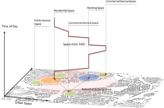
A classic theory that links time, space, and human activities is the time geography originally proposed by Hagerstrand (1970) . On the basis of the time geography conceptual framework, the time-space path and time-space prism were proposed to study the constraints of time and space on the location choices of activities (Dupuy, 2008 ). Figure 2 shows the relationship between an individual‘s daily activities (time-space path) and urban spaces. Green circles around urban service points are overlaid onto the building footprint of a city and indicate the catchment area of services. A 3D polyline represents an individual’s activity trip chain. A vertical segment of the line stands for the duration of an activity at the location where the vertical line is projected onto 2D base map. The line that connects two vertical segments approximates the process of the trips that link consecutive activity destinations. Virtually, a clear representation and visualization of these cumulative patterns would be helpful to understand the spatial and temporal heterogeneity that exists in a study area.
|
|
|
Figure 2. Space-time path of daily activities of an urban resident. |
Urban services affect people’s daily activities and location choices directly. From the perspective of service provision and use, facilities are divided into eight categories, namely, education, health care, sports, culture, social security, neighborhood management and service, communication and commercial, and financial services in China’s urban planning system.
According to the length of service time, the requirements of facilities’ location are different for the different target groups. For example, kindergarten and elementary schools are always divided into groups with short dwelling time and require multiple trips per day because children in China have to be dropped off by parents instead of taking the school bus. Those urban services usually take one of the following two locations. First, the facility that provides the service is located within the service radius of main residential neighborhoods. Second, the facility is located in the main corridors that connect residential neighborhoods and workplaces. In Chinese cities, the traditional work unit style of urban land use is most likely a good way to couple housing and workplace. In this land use type, urban services can usually be accessed from housing and workplace locations, and thus have a good chance to be used efficiently. After the reform of urban housing system and urban sprawl, the distribution of job and housing locations started to become complex (Chai et al., 2008 ).
The role of the household in individuals’ activity generation has been emphasized from the emergence of the activity-based approach (Jara-Díaz, 1998 ; Kockelman, 2001 ). A consensus is that one of the main objectives of carrying out activities is to meet the needs of the household. Thus, to understand the choice of urban services, accounting for intra-household interactions is necessary because the decision making by one household member is often conditioned by the activities of other household members by means of joint activity or resource and task allocation. For example, if only one worker exists in a household, then the responsibility of escorting kids to school will most likely fall to other household members. If two or more workers exist in a household, then a likely situation is that different household members will split the responsibility. In this case, a good choice of kindergarten or primary school is one close to home, thereby allowing each household adult member to fulfill his or her responsibility conveniently.
For the facilities that are typically used in a single trip with a short dwelling time, in addition to the locations close to home and to workplaces, urban residents can also visit the facilities located along the commuting route between home and work given the short dwelling time. These types of facilities include basic commercial facilities, such as convenience stores, pharmacies, and banks, as well as information and communication service facilities, such as post offices and mobile phone service centers. Other urban facilities, such as clinics, cultural activities, and sports facilities, require only a single trip and have a relatively flexible option for a layout position, being accessible from either main workplaces or residential neighborhoods. Facilities such as baby nurseries, farmers’ markets and community service centers are more likely to be established close to residential neighborhoods considering the demographic distribution of their users and political divisions.
On the other side, residents’ choices of housing, employment, and public services are to a great degree dependent on the characteristics of decision makers, including their household composition, income level, age, and lifestyle.
Table 1 summarizes the demographic distribution of urban residents in different types of urban areas on the basis of the authors’ recent studies and projects in the city of Nanjing in China. Young residents constitute the majority of the population in large residential projects in urban fringe areas. As Table 1 shows, most young urban residents choose housing in an urban periphery because housing prices in the city center or proximate to their workplace are too high. Thus, they have to endure the spatial mismatch between their housing and working locations. In general, young residents also have a higher demand for urban services, which are inadequately provided in the urban fringe. As a result, young urban fringe residents resort to services and facilities in more urbanized areas, thereby further exacerbating the conflicts between demand for supply of public services, such as education and health care, in those areas.
| Relocated residents | Residents of commercial housing in urban fringe | Residents of old neighborhoods in urban center | |
| Household composition | Nuclear family (the composition can be complex) | Nuclear family (mostly young couples) | Nuclear family (mostly old couples) |
|---|---|---|---|
| Job-housing location | Relatively balanced | Mismatch | Relatively balanced |
| Age group | Every age group | Mostly young and middle aged | Mostly old |
| Income level | 1000–3000 | 4000–6000 | Every income level |
| Daily activity area | Activity area is limited to neighborhood and surrounding areas because of lifestyle and economic capability. | Activity area is influenced by the locations of housing and workplace. Daily activities usually cover multiple areas. | Activity area is limited to neighborhood, surrounding parks, and schools because of age. |
| Demand for public services | Demand–supply mismatch. The need is hardly met by existing facilities, and the existing facilities are underused. | Demand surplus. Residents have high demand for public services. | Demand and supply are balanced. |
Source: Recent studies and projects in Nanjing, China conducted by the authors.
During our research, we found a typical family in the urban fringe area. This family includes four members: a young father, a mother, their child, and the wife’s mother. This type of combination is common in this area. Both young people recently started their careers; one of them is a doctor, and the other is a teacher. To avoid traffic, they have to get up early at five o׳clock in the morning and leave home in half an hour. The commuting time is approximately an hour and a half. The office is empty when they arrive. Their colleagues who live nearby will arrive approximately an hour later. Their child is only two years old. The grandmother has to take care of all the child’s needs, including meals and daily activities. When the child grows up, her grandmother will send her to kindergarten every day. The child’s parents come home at approximately 7 p.m. and enjoy their dinner as soon as they enter the house. This family represents those who live in the urban fringe area. They rarely enjoy the surrounding facilities because all their daily activities occur in the main city.
As more and more public housing is built, residents of public housing will become an important demographic group in urban society. In Chinese cities, public housing is usually placed in two areas. On the one side, most public housing projects are usually assigned to urban fringe areas, which will also face the issue of urban service shortage before the neighborhood matures. On the other side, to optimize the spatial layout of the urban space, some public housing projects have been planned to be executed side by side with commercial building projects so that the existing urban service can also be enjoyed by the residents of public housing. However, the mix of residents with different socioeconomic characteristics may also raise the issue that some supplies do not meet the needs of all residents.
Unlike the two groups of urban residents, residents of old neighborhoods in the urban center are usually old couples, who have a limited activity area. However, because services and facilities in the urban center are relatively complete and well established, this group of residents is generally satisfied with the provision of services and facilities. Moreover, they can also turn to the facilities in nearby schools even if they feel the facilities are not sufficiently supplied.
4. Study area
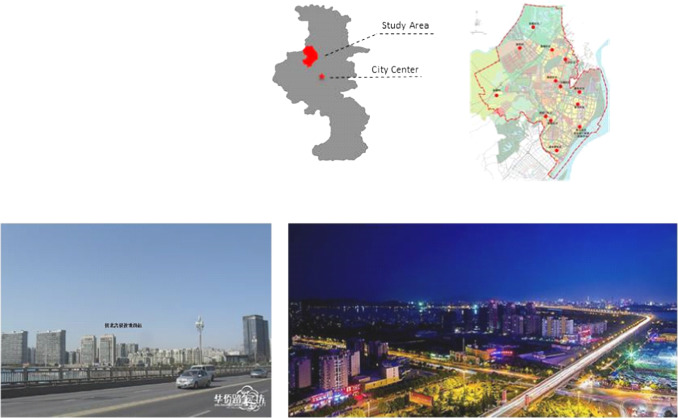
We selected the Qiaobei development district of Nanjing as our study area because it is representative of the urban growth pattern that can be observed in most large Chinese cities (Figure 3 ). The Qiaobei development district is located at the fringe of Nanjing’s metropolitan area. The Qiaobei development district covers a part of Pukou district, which accommodates a population of 717,000, including approximately 136,000 temporal residents whose permanent residence registration is not in the district, according to the Nanjing Annual Statistics in 2011 (Nanjing Statistics Bureau, 2012 ). The Qiaobei district is separated from major urban areas by the Yangtze River. Therefore, it has a relatively lagged development. The southern part of the study area is mostly urbanized, whereas the northern part of the study area shows fewer urban characteristics. The urban services and facilities in the study area are considered insufficient compared with other parts of Nanjing. Land patches in the area are mostly large and underused. Subdivision and more detailed plans are needed for further development.
|
|
|
Figure 3. Location and landscape of Qiaobei development district of Nanjing. |
4.1. Reason for case selection
The study area faces a variety of typical problems, such as the alternation of new and old urban space, and the renewal of the old city and reconstruction of a development zone. Therefore, the study area represents those common areas in the process of urban space expansion, thereby providing this research with typical significance. The typicality of this area is displayed in three aspects.
- Complexity in demographic constitution
This type of district is still undergoing the urbanization and development process; therefore, it is usually the place that will undergo significant dimorphic change. Many residents and farmers will relocate here. It is also populated with temporal residents, migrant workers, homeowners from other cities, college students, and employees. Thus, it usually has residents with a heterogeneous demographic background.
- Rapid development of large residential projects
According to the gradient of land rent, peripheral areas of a metropolis usually have lower land value than other urban districts that are more proximate to the core. The lands that can be developed are also not particularly scarce. These factors lead to the emergence of a large amount of super residential blocks in the urban fringe areas of large Chinese cities. The lag in the provision of public services makes living in these large-scale residential neighborhoods inconvenient. For a long time, residents have had to rely on the urban facilities provided by developers.
- Multifunctional development of the district
For a long time, the investment and development of urban facilities have usually focused on urbanized areas. Urban fringe areas, like the study area, need to take on large development projects, such as a new industrial park and a university town beside the residential project, thereby leading to a mingling of different urban spaces and functionalities. The provision of public services should not only satisfy the demand from local residents but also consider the needs of temporal residents, such as university students and workers. The complexity arises as different subgroups of a population have heterogeneous preferences and habit of using facilities.
4.2. Survey and hypothesis
This survey covers eight urban neighborhoods and five rural neighborhoods in three Jiedao (a geographical administrative parish equivalent to census tract in U.S. cities), Taishan Jiedao, Yanjiang Jiedao, and Panchen Jiedao, of the Qiaobei district. The sampled neighborhoods include both small traditional neighborhoods and large, fast-growing new neighborhoods. The survey is targeted at two groups of people: local residents and workers. With the help of a neighborhood committee, we sampled 250 individuals (because of financial constraints) in the study area and conducted in-room surveys. The following questions are included:
- Socio-demographic and economic background of respondents.
- Major factors that influence their choices of housing locations and jobs.
- The use of urban services and facilities, and its relationship with locations of home and work.
- How satisfied the residents and workers are with urban services and facilities in the Qiaobei district.
Out of 250 survey respondents, 247 provided useful answers. Such a high response rate ensured by the in-room survey helps to reduce the non-response bias that might otherwise be an issue in mailed surveys, telephone surveys, and online surveys.
In addition, this article will confirm the following hypothesis:
- The choices of housing, employment, and urban services are correlated and co-restricted.
- With the development of the urban fringe area, the commuting time of residents will not increase, and the separation between housing and workplace is not obvious.
- Income and age are the most important factors when choosing service facilities.
5. Analysis of survey results
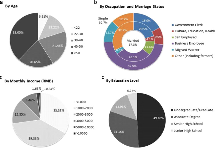
The study area is located on the border of the city of Nanjing and the surrounding rural areas, thereby resulting in the heterogeneous social-demographic characteristics of the residents. Approximately one-half of the survey target population is relocated farmers who lost their land because of the urbanization process. In addition to relocated farmers, residents who live in the area mainly consist of government clerks and business employees, as well as migrant workers. The survey sampled all age groups over 20 years old. In terms of housing tenure, the survey includes both renters and homeowners. In terms of residency history, the survey covers old residents, new residents, and temporal residents, whose residence is registered at the study area or the city of Nanjing (Figure 4 ).
|
|
|
Figure 4. Socioeconomic and demographic distribution of respondents. |
In addition to the local residents, we also randomly sampled people who work in the study area but live in other parts of the city.
As the survey results suggest, because most local residents are farmers or migrant workers, the income distribution of the respondents is biased toward the lower end, which indicates that the average income of workers in the study area is relatively low.
5.1. Employment and housing location choice
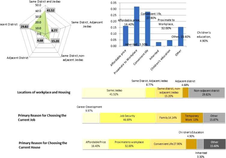
If we define job–housing mismatch as living and working in different districts and balanced job–housing as living and working in the same district, then approximately 65.5% of the respondents achieved relative balance in job–housing locations, and the remaining 34.5% of the respondents have a job–housing mismatch; most of the 34.5% are young and recently employed people (Figure 5 ). This finding is different from those of a few previous studies on the job–housing balance in development districts in Chinese cities (Liu, 2007 ), which found that the issue of serious job–housing mismatch exists in development districts because of the large-scale construction in such districts. The discrepancy in these findings can be interpreted according to two factors. First, the targeted population of this study contains a large number of farmers and immigrant workers who live and work in the same place. This group of people has a balance in job–housing locations. Second, the study area and its surrounding areas have been developed from an area with unique industrial land use to an area with mixed land use including residential and commercial developments, thereby allowing many workers to choose housing locations close to their workplaces. These factors further decrease the imbalance between job and housing locations of the district. Therefore, the paradigm of a job and housing location correlation of an urban fringe development district depends on its demography and land use pattern.
|
|
|
Figure 5. Job and housing choice of respondents. |
In accordance with the degree of job–housing mismatch and the level of development, Zhao et al. (2011) classified different parts of Nanjing into four groups: urban center mixed developed area, suburban mixed developed area, new bedroom neighborhoods, and urban fringe mixed developed area. The area investigated in this study belongs to the urban fringe mixed developed area.
With regard to the factors that led the respondents to choose to live in the study area, 32% of the respondents agreed that proximity to their workplace was the primary reason. A total of 27.9% of respondents thought that well-developed facilities and services nearby was the main factor that influenced their housing location choice. Housing price was also a main factor. Approximately 16% of the respondents claimed that their housing location choice was due to low housing prices in the study area. These findings are in line with conclusions from other research. Zhang et al. (2003) found that people favor housing locations proximate to places, such as the workplace, schools, or supermarkets, which are all important constituents of their daily activities. In his study, accessibility is believed to be the most influential factor, as 77.13% of the interviewees agreed. Workplace location will usually restrict the spatial choice of housing locations. Zhao and Wang (2010) studied the relationship between living and working in the area of the Shanghai–Nanjing expressway corridor and found that 60% of people are unwilling to change their jobs to accommodate existing settlements.
5.2. Commuting pattern
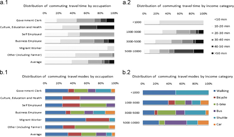
The connections between housing and workplace locations are studied through commuting patterns. Figure 6 shows the breakdown of commuting time according to occupation types and income levels. In general, the commuting time of local residents is relatively small; more than 80% of the respondents have a commuting time of 30 min or less. This finding is also consistent with the housing–job balance pattern discussed in the last section.
|
|
|
Figure 6. Distribution of commuting transportation modes of respondents. |
Among all the respondents, migrant workers and self-employers tend to work in a place close to home. Most migrant workers are likely to work on the construction fields and live in temporal dorms that are close to construction sites. By contrast, some government clerks and business employees have to spend more than 40 min commuting. Of workers in the education, cultural, and health sectors, approximately half spend more than 40 min commuting daily. A comparison across income categories indicates that commuting travel time is clearly positively correlated with monthly income. Workers with a monthly income less than 1000 RMB rarely spend more than 20 min commuting. However, commuting appears to be a more time-consuming experience for respondents with a monthly income over 5000 RMB. Approximately 50% of respondents in this group spend more than 40 min commuting.
In terms of the transportation mode of commuting, because a large portion of the respondents are migrant workers and farmers, the percentage of car use is reasonably low. Some government agencies and enterprises provide their employees with shuttles for commuting; thus, the percentages of company shuttle use for government clerks and business employees is 20% and 15%, respectively. In addition, walking and cycling are the predominant transportation modes for migrant workers. Public transportation is used heavily only by workers in the education, cultural, and health sectors. Notably, electronic bikes account for a considerable share in most groups, except for migrant workers and workers in the education, cultural, and health sectors.
Figure 6 shows the breakdown of commuting transportation modes by income category. Respondents with an income of less than 1000 RMB rely mainly on walking and company shuttles to get to their workplace. As the income increases, the percentage of non-motorized travel modes decreases.
We also included questions related to housing purchase in the survey. The intention to buy a new home grows with the rise of income level. Almost half of the respondents with a monthly income over 3000 RMB intend to buy a home. In terms of occupation, government and enterprise employees have a stronger propensity to buy a home than self-employers and migrant workers. Most respondents agreed that they favor residential buildings proximate to their workplaces if the price is affordable.
5.3. Living facilities and services
Understanding the choice of living facilities and services in daily life is not only critical for comprehending the daily activities and urban spaces usage of residents but also helps planners and developers provide appropriate services that match the needs of citizens (Figure 7 ). When respondents chose educational institutions, most of them thought that their main reason for choosing a particular kindergarten was its accessibility from their homes. With regard to elementary school and junior high school, the quality of education is regarded as equally important to proximity to home. Meanwhile, for the migrant workers who are not locally residentially registered, the choices of kindergarten and primary school are limited to several schools that have spaces for immigrant students.
|
|
|
Figure 7. Choice modes of educational institutions of respondents. |
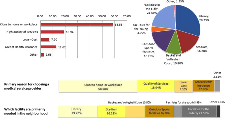
The main health services are provided by community clinics because of a lack of hospitals in the study area. Thus, approximately 60% respondents will consider choosing the health service providers that are close to home or work when their sickness is not severe.
With regard to the need for other facilities within the community, 60% of the respondents would like to have more outdoor exercising facilities, basketball or volleyball courts, and community libraries for two reasons. First, these facilities are not sufficiently provided. Second, young migrant workers demand outdoor sport facilities. The mismatch between the service demand and supply leads to a waste of resources; many existing facilities, such as children’s playgrounds and community schools, are underused (Figure 8 ; Figure 9 ).
|
|
|
Figure 8. Choice of other facilities within the community of respondents. |
|
|
|
Figure 9. Community’s satisfaction with the facilities by income and occupation. |
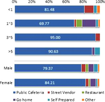
In terms of dining choice, the majority of the respondents choose to dine in public cafeterias (Figure 10 ). The pattern does not vary dramatically across the subgroups that are differentiated by working years and gender.
|
|
|
Figure 10. Dining choice mode of respondents. |
In terms of daily shopping, more than 55% of the respondents went to the markets or grocery stores within the neighborhood; in comparison, 17.8% shop in the urban center. Public transportation is more accessible and frequent in the study area than in other neighborhoods. Therefore, respondents who live in the TaiShan neighborhood generally shop more frequently in the city center than residents of other neighborhoods. More than 30% of the respondents shop in the city center at least once every one or two weeks. Half of the respondents shop in the city center at least once every month. However, in the Yanjiang neighborhood, more than 60% of the respondents shop in the city center only once or twice a year. Residents of this neighborhood generally tend to shop within the study area if they have no specific shopping needs. The Longpan neighborhood is geographically separated from the city center by the Yangtze River and the Longwang Mountain. Rather than traveling one and a half hours to the city center, residents are more willing to shop in a nearby suburban center, DaChang district. Therefore, the location choice of shopping depends, to a large degree, on the accessibility by public transportation.
5.4. Residents’ overall satisfaction level
We also asked respondents attitudinal questions about their satisfaction level with the provided facilities and services in the study area. Overall, respondents have a higher degree of satisfaction with educational, cultural, and sporting facilities than for health and public transportation services. Public transportation serves as an important channel that connects residents over their daily activity spaces. Good public transportation can alleviate the issues caused by insufficient supply of service. However, as is the case with most other development areas in the urban fringe, public transportation can hardly meet the demand of local residents, who are more likely to rely on public transportation for middle- and long-distance trips. More than 55% of the respondents are not contented with the provided public transportation service.
6. Conclusion and discussion
The choice and preference of housing and employment of urban residents accounts for the needs of household members in addition to their own daily activities. Thus, studies on location choices need to focus on the activities of individual residents, which are influenced by their households. This study found that the choices of housing, employment, and urban services are correlated and co-restricted, thereby leading to different patterns of job–housing distribution and service use. The choice of housing location is usually related to the location of the workplace. The level of urban services is also a factor that influences the preference of housing location.
The accessibility of the workplace to the home also determines other daily activities, such as dining, shopping, and recreation. In urban forms with balanced job and housing distribution facilities, the residents are engaged in other activities in the surrounding areas. In comparison, residents with dispersed job and housing locations tend to be engaged in the other activities at locations proximate to their home. The emergence of public cafeterias near major workplaces has gradually attracted more workers and nearby residents to dine there.
We also found that income has a great impact on the choice of housing and urban services, and the tolerance of commuting time. High-income residents care more about their jobs, thereby leading them to accept a long commuting time at the start of their career. However, as they achieve stability in their career, their willingness to move to a location closer to their workplace is usually strong. In terms of public services in the urban fringe, most respondents believed that the provision of urban services and facilities will improve as the residing duration increases. The satisfaction level is high given the real situation of service and facility provision, thereby suggesting that in the minds of urban fringe residents, jobs and housing are more important than urban services.
As an important part of urban and rural planning, public service facilities have a close relationship with their space location in the city, user attributes, properties of the facility, and phase of city׳s overall development. Support for the public service facilities should adjust measures to local conditions and reduce the effects of social class differences and the influence of social development stage as much as possible.
A questionnaire inquiry can reflect the implementation of the original planning. Such an approach can also help to optimize and adjust the space location of facilities according to the actual development situation, as well as improve their service quality and level by understanding the usage and residents’ preference of public service facilities.
With the research area as an example, three suggestions for planning can be presented. First, by making a time entry of service facilities’ configuration, we can not only avoid inconvenience due to loss of service facilities in large communities, but we can also avoid waste due to low utilization rate of facilities. Second, in accordance with the transitional characteristic of the lack of service facilities in metropolitan fringe areas, we can increase internal public transportation lines across regions to improve the public transport environment or provide more facilities around the working places, thereby providing the residents with more choices of facilities. Third, in accordance with the population complexity of the urban fringe area, urban planning must meet the personalized needs of different people as much as possible to improve the quality of service. For example, we can increase public service facilities for the elderly in a community that is mostly populated by elderly people and combine such facilities with the park in the community or locations surrounded by a good environment.
Acknowledgments
This research is funded by National Natural Science Foundation (No. 51078071 and No. 51408318).
References
- Carruthers and Ulfarsson, 2003 J.I. Carruthers, G.F. Ulfarsson; Urban sprawl and the cost of public services; Environ. Plan. B, 30 (4) (2003), pp. 503–522
- Cervero and Wu, 1998 R. Cervero, K.L. Wu; Sub-centring and commuting: evidence from the San Francisco Bay area, 1980-90; Urban Stud., 35 (7) (1998), pp. 1059–1076
- Cervero, 1995 R. Cervero; Planned communities, self-containment and commuting: a cross-national perspective; Urban Stud., 32 (7) (1995), pp. 1135–1161
- Chai et al., 2008 Yanwei Chai, Zhilin Liu, Jie Shen; Changes of the DANWEI system and its effects; Arid Land Geogr., 2 (2008), pp. 155–163
- China State Statistical Bureau, 2012 China State Statistical Bureau, 2012. China Urban Statistical Yearbook 2012. Beijing, China.
- Dupuy, 2008 Gabriel Dupuy; Urban Networks – Network Urbanism, Techne Press, Amsterdam (2008)
- Gordon et al., 1989a P. Gordon, A. Kumar, H. Richardson; Congestion, changing metropolitan structure, and city size in the United States; Int. Reg. Sci. Rev., 12 (1989), pp. 45–56
- Gordon et al., 1989b P. Gordon, A. Kumar, H. Richardson; The influence of metropolitan spatial structure on commute time; J. Urban Econ., 26 (1989), pp. 138–151
- Hagerstrand, 1970 T. Hagerstrand; What about people in regional science?; Pap. Reg. Sci. Assoc., 24 (1970), pp. 7–21
- Hortas-Rico and Solé-Ollé, 2010 M. Hortas-Rico, A. Solé-Ollé; Does urban sprawl increase the costs of providing local public services? Evidence from Spanish municipalities; Urban Stud., 47 (7) (2010), pp. 1513–1540
- Jara-Díaz, 1998 S.R. Jara-Díaz; A general micro-model of users’ behavior: the basic issues; J. de D. Ortúzar, D. Henshery, S. Jara-Díaz (Eds.), Travel Behavior Research: Updating the State of Play, Pergamon, Oxford (1998)
- Jianfeng, 2007 Jianfeng Liu; The bottleneck of job-housing balance from development zone to comprehensive new city: reflection and enlightenment of Guangzhou Development Zone; Beijing Plan. Rev., 3 (2007), pp. 12–15
- Kenworthy and Laube, 1999 J.R. Kenworthy, F.B. Laube; Patterns of automobile dependence in cities: an international overview of key physical and economic dimensions with some implications for urban policy; Transp. Res. Part A: Policy Pract., 33 (7) (1999), pp. 691–723
- Kockelman, 1997 K.M. Kockelman; Travel behavior as function of accessibility, land use mixing, and land use balance: evidence from San Francisco Bay Area; Transp. Res. Rec.: J. Transp. Res. Board, 1607 (1) (1997), pp. 116–125
- Kockelman, 2001 K.M. Kockelman; A model for time-and budget-constrained activity demand analysis; Transp. Res. Part B: Methodol., 35 (3) (2001), pp. 255–269
- Levinson and Kumar, 1994 D.M. Levinson, A. Kumar; The rational locator: why travel times have remained stable; J. Am. Plan. Assoc., 60 (3) (1994), pp. 319–332
- Meyer et al., 1965 J.R. Meyer, J. Kain, M. Wohl; The Urban Transportation Problem; Harvard University Press, Cambridge, MA (1965)
- Nanjing Statistics Bureau, 2012 Nanjing Statistics Bureau; Nanjing Statistical Yearbook; China Statistics Press, Beijing (2012)
- Nelson and Duncan, 1995 Nelson, A.C., Duncan, J.B., 1995. Growth Management Principles and Practices. American Planning Association.
- Pan et al., 2009 H. Pan, Q. Shen, M. Zhang; Influence of urban form on travel behaviour in four neighbourhoods of Shanghai; Urban Stud., 46 (2) (2009), pp. 275–294
- Peng and Zhu, 2007 Z.R. Peng, Y. Zhu; Urban Transport in Chinese Cities: The Impact on the Urban Poor; Woodrow Wilson Center Press (2007), pp. 144–170
- Schwanen et al., 2004 T. Schwanen, M. Dijst, F.M. Dieleman; Policies for urban form and their impact on travel: the Netherlands experience; Urban Stud., 41 (3) (2004), pp. 579–603
- van de Coevering and Schwanen, 2006 P. van de Coevering, T. Schwanen; Re-evaluating the impact of urban form on travel patternsin Europe and North-America; Transp. Policy, 13 (3) (2006), pp. 229–239
- Xiao et al., 2006 J. Xiao, Y. Shen, J. Ge, R. Tateishi, C. Tang, Y. Liang, Z. Huang; Evaluating urban expansion and land use change in Shijiazhuang, China, by using GIS and remote sensing; Landsc. Urban Plan., 75 (1) (2006), pp. 69–80
- Zhang, 2000 Tingwei Zhang; Land market forces and government’s role in sprawl: The case of China; Cities, 17 (2) (2000), pp. 123–135
- Zhong et al., 2003 W. Zhang, W. Liu, Y. Li; Housings’ spatial distribution and residents’ preference on housing location in Beijing; Geogr. Res., 29 (12) (2003), pp. 1532–1540
- Zhao and Wang, 2010 H. Zhao, X. Wang; A preliminary study on regional combination of living and working in Shang Hai–Nanjing high-speed rail transit corridor areas; Urban Plan. Forum, 23 (1) (2010), pp. 85–90
- Zhao et al., 2011 H. Zhao, J. Yang, C. Liu, K. Wang; Measurement method and characteristics of spatial organization for jobs-housing misbalance: a case study of the effects of metro systems on jobs-housing misbalance in Beijing; Prog. Geogr., 30 (2) (2011), pp. 198–204
Document information
Published on 12/05/17
Submitted on 12/05/17
Licence: Other
Share this document
Keywords
claim authorship
Are you one of the authors of this document?
