1. Introduction
This paper presents a new perspective for engineers when planning, designing, and managing transportation systems−as well as for those restoring and replacing ageing infrastructure. It provides evidence on how taking a “human” approach to transport will enable engineers to find smarter ways to move people and goods across cities, countries, and continents. Human-centered mobility puts the user directly at the heart of design and decision making. By adopting this approach, we can create efficient and resilient transport solutions that are mutually beneficial for both passengers and operators and which shape better cities and communities.
2. Challenge and opportunity
It is predicted that by 2050 the human population will reach 9 billion with 75% of the worlds inhabitants living in towns and cities. With this continuing shift to urban living, cities are facing far greater social, economic, and environmental pressures. From London to Shanghai, our cities are facing many issues associated with rapid urbanisation and, inevitably, our transport infrastructure is taking the strain. Widespread congestion has become the norm, which impacts urban life through carbon emissions, air and noise pollution. We need to find ways of addressing these issues whilst delivering additional capacity.
But it is not all bad news. Greater population density also brings opportunities and urbanization can unlock the funding of large scale transport infrastructure projects. We, as designers, can help conceive city-wide integrated transport systems that are efficient and reduce the impact on the environment whilst delivering economic growth, health benefits, and social cohesion to the places we live. In doing this we must not lose sight of the most important element−the individual passenger and their desire for a simple seamless journey. We must focus on accessibility and mobility, as opposed to modes of transport in isolation.
The development of transport infrastructure remains high on governments' and city planners' agendas, but transport must not be viewed in isolation. Policy inter-relationships need to be recognized and addressed as part of an overall strategy. In 2014, the Mayor of London launched the citys first long-term infrastructure plan, which Arup significantly contributed to. It was the first attempt to identify, prioritize, and cost Londons future infrastructure. The plan set three overarching objectives for long-term strategic transport investment: to support London and the UKs economy; to serve a growing population; and to make London more liveable. The plan clearly citied “human-centered” modes of travel as a priority.
It is increasingly recognized that transforming our transport systems can help improve the economic and social quality of neighborhoods. Even micro measures, such as introducing tree cover and green space as part of city planning and infrastructure projects, encourage people to seek alternative methods of transport and pursue healthier lifestyle choices. Our “Cities Alive” research into the implementation of green infrastructure has shown that promoting healthier, more outdoor-oriented lifestyles can reduce deaths by 2 to 6 in 1000. This also has a considerable economic benefit. A UK Forestry Commission report states that motivating a permanent 1% reduction in the sedentary population of the UK is estimated to deliver a benefit of up to £1.44 billion a year in economic benefits to the economy, equivalent to £800 per person.
The impact on health is an important element of human-centered design as transport systems have a highly significant role to play in helping to tackle the major public health challenges our cities face. Transport can be the cause of poor health (physical inactivity, poor air quality, noise) but it can also be the cure (active travel, improving air quality, and reducing noise). The World Health Organization data estimates that physical inactivity accounts for nearly one in ten premature deaths worldwide. Coronary heart disease, colon cancer, diabetes, stroke, and breast cancer are all linked to physical inactivity. It is estimated that, in Europe, inactivity could be killing more than twice as many people as obesity. University of Cambridge researchers have stated that getting everyone to do at least 20 minutes of brisk walking a day would have substantial benefits. And it is not just physical health. Inactive people have three times the rate of moderate to severe depression compared to active people. Being active is central to our mental health and feelings of general well-being. Dementia is now the leading cause of death for women in England and Wales as it is now responsible for 12% of all female deaths. Undertaking regular exercise, such as walking, can cut an individuals risk of getting dementia by 30%.
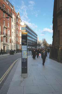
Active travel is the most viable option for significantly increasing physical activity levels across the population and the choice to walk or cycle is strongly influenced by urban settings and transport policy. Policies to encourage walking should be placed at the heart of future urban mobility strategies and indeed all our decisions about the built environment: Walkable cities are better cities for everyone. The built environment needs to encourage healthier choices so we need to design physical activity back in to our everyday lives by incentivising and facilitating walking and cycling as regular daily transport. Wayfinding systems like Legible London (Fig. 1 ), which saw the implementation of on-street signage tailored specifically for pedestrians, are one example of a step in the right direction.
|
|
|
Fig. 1. Legible London, Transport for London (TfL)s wayfinding system. ©Arup/Thomas Graham. |
In addition to the host of health benefits, there are many economic benefits for developers, employers, and retailers when it comes to walking. It is the lowest-carbon, least polluting, cheapest, and most reliable form of transport. It is a great social leveller and having people walking through urban spaces makes them safer for others and, best of all, it makes people happy. Getting more people walking and cycling to work would make for a healthier workforce and research also shows that absenteeism rates are lower among staff who cycle and that active commuters are better able to concentrate and under less strain than those who travel by car.
Bringing about change is challenging but cities can consider both trials and incremental steps to achieve their ambitions. The Korean city of Suwon embarked on a radical experiment in 2014: For one month the neighborhood became a car-free zone, which allowed the residents to envisage a low-carbon alternative. After the trial, people did not want to return to the way things had been, but chose to adapt their behaviors and keep elements of the trial.
In Freiburg, Germany, they spent 40 years making incremental changes to the transport system to take it toward its long-term vision of a city that promotes walking, cycling, and public transport. This is a prime example of how a series of interventions can build a sustainable transport system, if there is the foresight by government and a holistic approach to transport is adopted.
3. Human-centered mobility
Historically, different modes of transport have been considered separately−with separate policy teams, separate funding, and separate providers. While this reflects how the industry operates, it does not reflect the way people think about their journeys. The primary objective of the real life person at the heart of our engineering solutions is to get from A to B at an affordable cost in the most efficient way. And while shaping the new architecturally impressive airports, stations, and transport hubs, we have too often lost sight of the human element and the seamless journey.
So what would good human-centered mobility look like?
The transport system needs to be user-centric with all elements from ticketing to wayfinding highly intuitive. It needs to be efficient, cost-effective, and accessible to the widest population, so it can support a growing and vibrant city. The system should be mode agnostic, so a passenger can switch between walking or cycling, or taking a bus, tram, or car as this provides flexibility, but is also inherently resilient if there is failure in one mode or maintenance is required. The ticketing system and real-time information should enable seamless end to end journeys across all modes.
This sounds simple yet behind those straightforward principles, lie multi-layered complexities. It is our job to tackle that complexity and use behavioral knowledge with our engineering expertise to create networks that are seamless and simple for the user.
4. Future trends and influences
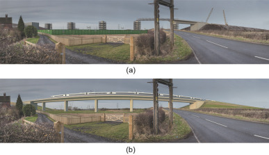
If you look around the globe there are clear examples of what the future of transport might look like and how transport is indeed becoming more focused upon the needs of the passenger. High-speed rail in many regions, including China, is slashing journey times and diminishing the need for short-haul air travel. Arup has been a strong advocate of high-speed rail, even before our first involvement in the UK Channel Tunnel Rail Link in the 1980s. High-speed rail offers a sustainable, progressive means of managing the economic and environmental cost of road and air travel, as well as offering fast connectivity and a positive passenger experience. For example, the planned high-speed rail network from London to Birmingham and to Manchester and Leeds, High Speed 2, could transfer 4.5 million journeys a year from the air and 9 million from the roads, removing lorries from busy routes (Fig. 2(a) and (b) ). High Speed 2 will reach speeds of up to 250 miles·h−1 (about 402 km·h−1 ), which is faster than any current operating speed in Europe, and would cut Birmingham−London journey times from 1 h 21 min to 49 min.
|
|
|
Fig. 2. The latest visualization technologies enable us to combine the wealth of available data to communicate the High Speed 2 scheme in visually accurate way. ©Arup. |
There is a growing trend in shared ownership of vehicles (and bicycles) which is fuelled by mobile applications. This can free up much city space previously taken up by parked cars for other urban uses. In Berlin, the citys excellent public transport and bicycle paths combined with the opportunity for sharing mean that most residents do not own a car and most visitors do not require one.
Whilst awaiting the arrival of autonomous vehicles, the development of electric vehicles, and the greater provision of charging points is making these a realistic alternative. In the UK, an Arup-Mitsui joint venture in Milton Keynes is currently trialling an innovative approach to charging electric buses and this heralds a quieter, cleaner future for public transport. The new buses are able to recharge their batteries wirelessly through the day, which means that for the first time, electric buses are capable of carrying the equivalent load of a diesel bus.
What is clear is that modes of transport have not significantly changed over the 20th century, but the context in which they operate and how we travel has. This is mainly due to advances in technology. Before payment cards such as the Octopus card and Oyster card, it was normal to queue to buy a ticket for each stage of your journey. This wasted a huge amount of peoples time and was not an efficient or cost-effective system. The increased use of technology has created a “new normal” for cities around the globe, creating more seamless systems, making peoples lives easier and reducing costs for the operator.
Now, we are seeing the rise of journey planner apps and their success is due to their user-centric nature. They have become a powerful tool that can tell people everything from the quickest route to their destination to finding an available cycle rack. In addition, these apps, such as Didi Kuaidi, Citymapper, City Bikes, Roadify, HotStop, and Waze, give a significant boost to the digital economy. Arups Urban Mobility in the Smart City Age report considers the opportunities available for cities to improve the operational efficiency and traveller experience of their transport systems, while generating new economic value. We have estimated that $720 billion to $920 billion USD could be generated across the globe every year by utilizing open data to develop new digital transport applications.
Going beyond apps, in the UK, we are working on an innovative smart cities initiative called oneTRANSPORT which will lay the foundations for smarter transport networks around the world. This intelligent transport system (ITS) project aims to enable multi-modal transport information, such as live information about rail delays, traffic jams, or disruption to be easily published by data owners (e.g., transport authorities and third parties) through personalized services. Once published, this data can be accessed nationally by transport authorities, application developers, and others to develop new services to create better journeys for passengers.
By integrating smart technologies, we will make our transport systems more flexible and resilient to current and future travel patterns and we can also help build a prosperous economy. Smart cities not only make societal sense, they also make economic sense.
5. Engineering the future of human-centered transport
It falls to us to achieve the future that awaits. Thankfully, engineers have been steadily adding tools to their armory to make the design process easier and more efficient. Visualization, MassMotion, and GIS Mapping are tools which assist us in objectively communicating the complexities we are trying to achieve and in the design coordination and delivery of the projects. Public perception and consultations are increasingly becoming an influential part of the decision making process. As a response, we are now able to visualize the future before it is built through immersive technologies and tools throughout the entire design process.
These latest visualization technologies enable us to combine the wealth of available data across all specialisms and both coordinate and communicate the whole scheme to non-technical and technical audiences, so they have a complete and objective understanding what these proposals mean to them. This ability to visualize and communicate has been critical on the High Speed 2 rail project in the UK during the consultation of the proposed route and throughout the parliamentary process.
Whilst the scheme is complex and it is hard to understand the potential impacts to the environment, our visualization methods allowed us to communicate the route and its infrastructure with far greater clarity. We applied our pioneering auralisation SoundLab technology to produce verified sound demonstrations and visualizations for High Speed 2 to help stakeholders form a view about the acoustic and visual impact and input to the design process. This approach focuses on the human perspective and their understanding of the total design.
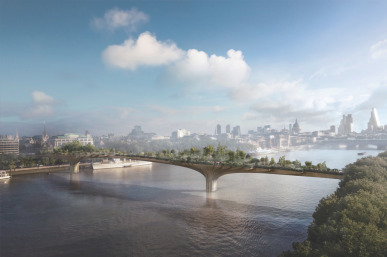
On the Thomas Heatherwick designed Garden Bridge in London (Fig. 3 ), we were able to simulate standing on the bridge in virtual reality to allow residents, Transport for London (TfL), the City of London, the police, and other stakeholders, to experience the proposed design, including its planting, lighting, pedestrian movement, and new vistas of London.
|
|
|
Fig. 3. Visualization of the proposed Garden Bridge, London. |
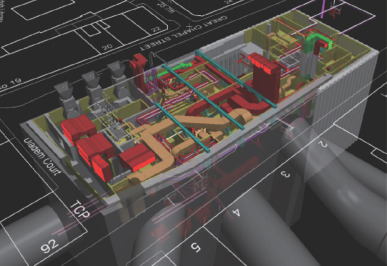
We also use geographic information system (GIS) technology to visualize, manage, analyze, and collate data based on any location. GIS can be implemented on complex civil engineering schemes before and during construction. Specifically on Crossrail, our real-time reporting solutions are part of an award-winning GIS strategy that integrates data management across the entire project (Fig. 4 ). It provides useful evidence of cost and time savings, as well as demonstrating risk mitigation through ensuring the appropriate use of data and information.
|
|
|
Fig. 4. A geographic information system (GIS) created image of new Crossrail station at Tottenham Court Road, London. ©Arup. |
In the planning and design stages, tools like MassMotion enable us to focus on human mobility by predicting how peoples journeys will intersect at a particular station or terminal. These facilities are frequently the connective tissue upon which entire regional transportation systems are built. MassMotion dynamically simulates the decisions and movement of pedestrians within 3D models of these buildings using detailed operational data such as airline and rail schedules. The simulation results provide clear information about how efficiently and comfortably people will make connections between different modes on their journeys. Whether a new build project or proposed modifications to existing facilities, the predictive power enables multiple scenarios to be explored and positive decisions to be made early in the design process enabling optimization of the user experience of hundreds of thousands of individuals. We can use tools such as MassMotion to break down the silos between different modes of transport and avoid a disconnect between user, designer, and operator.
6. Conclusions
A mobility revolution is happening before our eyes and we are making great strides in moving towards seamless transport solutions. We need to continue to maintain our focus on human-centered mobility, and use the many tools available to us, if we are to address the impacts of urbanization, meet the needs of users, and deliver the best transport infrastructure for our expanding cities.
Compliance with ethics guidelines
Dervilla Mitchell, Susan Claris, and David Edge declare that they have no conflict of interest or financial conflicts to disclose.
Document information
Published on 06/04/17
Licence: Other
Share this document
claim authorship
Are you one of the authors of this document?


