Abstract
Monthly temperature and precipitation time-series for the Zhujiang River Basin are analyzed in order to identify changes in climate extremes. Daily temperature and precipitation data from 1961 to 2007 of 192 meteorological stations are used. Two temperature indicators (monthly mean and monthly maximum mean) and three precipitation indicators (monthly total, monthly maximum consecutive 5-day precipitation, and monthly dry days) are analyzed. Tendencies in all five indicators can be observed. Many stations show significant positive trends (above the 90% confidence level) for monthly mean temperatures and monthly maximum mean temperatures. For all months, a significant increase in temperature from 1961 to 2007 can be observed in the entire basin with the coastal area in particular. Positive trends of precipitation extremes can be observed from January to March. Negative trends are detected from September to November. The number of dry days in October increased significantly at 40% of all meteorological stations. Stations with changes of monthly precipitation extremes are scattered over the Zhujiang River Basin. An aggregation of heat waves and droughts can be detected which is accompanied by significant increases of temperature extremes and the negative tendencies in precipitation extremes. The detection of tendencies in climate extremes essentially relies on a good data quality and high station density.
Keywords
temperature ; precipitation ; extremes ; Zhujiang River Basin ; China
1. Introduction
In the context of climate change impacts in China, the analysis of observed climate extremes is of high scientific interest. In China’s National Assessment Report on Climate Change [ Ding et al., 2007 ] and in numerous scientific articles [ Zhai et al., 1999 ; 2005 ; 2009a ; 2009b ; Zhang et al., 2007 ] the variations of climatic trends in China and its various sub-regions are studied. Climatic changes in East and South China are mainly associated with the East Asian Monsoon conditions. An increase of temperature, especially in winter, and higher variability of precipitation in the last decades are the foremost effects compiled for China. An increase in temperature and precipitation extremes is likely to lead to prolonged and more frequent droughts and flood events. For a detailed climate change impact assessment and further adaptation procedures, a regionalization of observed climate extremes (e.g., on basin scale) is important.
In recent years, a number of regional studies [ Zhang et al., 2009a ; 2009b ; Liu et al., 2009 , Yang et al., 2010 and Gemmer et al., 2010 ; Fischer et al., 2010 ] investigated climate extremes and their variations for the Zhujiang River Basin. They deal with different climatic variables, time-series, and relatively low station density. Gemmer et al. [2010] observed increasing tendencies to dryer conditions and stronger precipitation intensities in the Zhujiang River Basin from 1961 to 2007. Increasing rates of seasonal air temperature in 1961–2007 have been detected by Liu et al. [2009] with the highest in winter and lowest in summer. They also observed increases in annual temperature and precipitation records. A trend to more wet conditions from 2001 to 2050 under the SRES-A1B scenario was projected by Zhai et al. [2009b] using ECHAM5 outputs.
These studies on climatic changes in the Zhujiang River Basin use different climatic indicators, number of stations, and time-series. The temporal focus was mainly on tendencies of annual and seasonal data. The present study analyzes changes of monthly temperature and precipitation extremes and their spatial pattern in the Zhujiang River Basin. The tendencies of climate indicators are assessed by trend tests. The objective of the study is to identify and analyze tendencies in monthly climate extremes, making use of the highest number of meteorological stations (192) and longest continuous and homogenous time-series available (1961–2007). The results will give important details to managing climate change adaptation and disaster management (e.g., flood and drought preparedness).
2. Regional setting, data and methods
The Zhujiang River (also known as the Pearl River) Basin is located in South China. It has an extent of about 579,000 km2 [ Zhai et al., 2009a ]. Situated in tropical and sub-tropical climates, the East Asian Monsoon influences the entire basin. The basin’s west is mountainous with an elevation of up to 2,500 m. In the eastern part mainly flat or hilly low lands prevail (Fig. 1 ). Following the main topographical steps, the hydrological systems flow from the West and North towards the South-east Coast.
|
|
|
Figure 1. Location of meteorological stations of the Zhujiang River Basin, South China, elevation, and main rivers |
Daily data of temperature and precipitation from 192 national and provincial meteorological stations in the Zhujiang River Basin (Fig. 1 ) were provided by National Climate Center of China Meteorological Administration (CMA). Daily data is available for 1961–2007. Applying different relevant homogeneity tests [ Alexandersson, 1986 , Buishand, 1982 and Peterson et al., 1998 ], the data was successfully checked to be homogenous by the National Meteorological Information Center of CMA [ Song et al., 2004 ]. Five indicators have been defined on standardized classifications of CMA regulations. Monthly averages (maxima) were generated by the arithmetic means (maxima) of daily records. The monthly mean temperature and maximum mean temperature (highest mean temperature record per month) were chosen to characterize the trends in temperature. Monthly total precipitation (accumulated), maximum consecutive 5-day precipitation (highest amount of accumulated precipitation in five consecutive days), and dry days (number of days with precipitation below 0.1 mm) have been selected to describe tendencies in precipitation pattern. The NCEP reanalysis data (1948–2010) (http://www.esrl.noaa.gov/psd/ ) [ Kalnay et al., 1996 ], was used to visualize the characteristics of relative humidity (at 850 hPa) and wind pattern, and to analyze the influence of large-scale circulation to monthly climate extremes.
The linear regression method and the non-parametric Mann-Kendall trend test [ Gemmer et al., 2004 , Liu et al., 2008 and Yang et al., 2010 ] were applied to the monthly indicators. The linear regression was used to obtain the increase rates per decade (°C per 10 year; α = 0.9) of each indicator. Positive or negative trends based on Mann-Kendall statistics were considered as significant when passing the 90% confidence level. If results are significant below 90% confidence level, they are assigned positive or negative tendencies. The inverse distance weighting (IDW) method applied in the geographical information system (ArcGIS) was used to interpolate and visualize the trends and tendencies of all 192 meteorological stations.
3. Results
3.1. Temperature changes
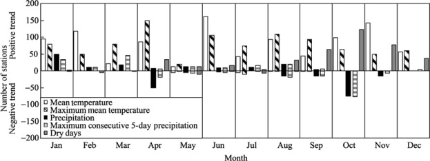
Results on monthly basis for the five indicators with their respective number of meteorological stations (out of 192) with significant trends can be seen from Figure 2 . These trends are based on the time-period 1961–2007. The first two bars in each month correspond to temperature indicators, while the following three show precipitation indicators.
|
|
|
Figure 2. Number of stations with significant trend above the 90% confidence level (Mann-Kendall statistics) for five indicators in the Zhujiang River Basin, 1961–2007 |
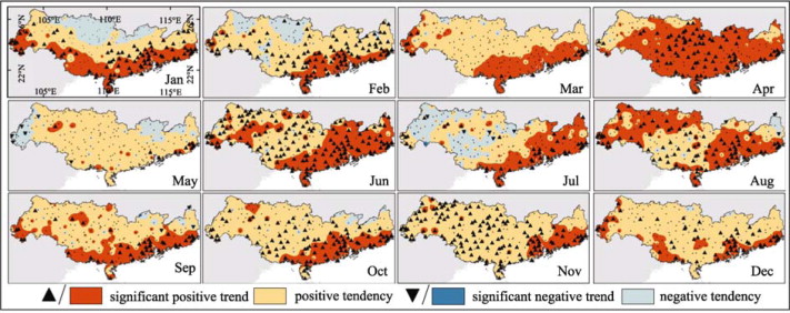
As illustrated in Figure 2 and Figure 3 , various stations with significant positive trend of mean temperature and maximum mean temperature can be observed in all months. In four months (Feb, Jun, Oct, Nov) more than 50% of all stations show positive trends of mean temperature. For maximum mean temperature only in three months (Apr, Jun, Aug) the number of stations reaches 50%. In four months (May, Jul, Aug, Sep), few significant negative trends (between 3 and 12 stations, below 6% of all stations) can be observed for the two temperature indicators.
|
|
|
Figure 3. Monthly trends (Mann-Kendall statistics) of maximum mean temperature (shadings) and mean temperature (triangles) in the Zhujiang River Basin, 1961–2007 |
The spatial distribution of stations with significant trends (and tendencies) of temperature indices shows a distinct pattern (Fig. 3 ). The major part of the basin shows positive tendencies throughout all months. Temperature indicators show the densest increase along the coast (increase of up to 0.7 °C per decade) in all month. Only the northern and western areas show slight negative tendencies in four months (Jan, Feb, May, Jul; decrease of −0.01 °C per decade).
The change of the basin’s average monthly mean temperature (1961–2007) is presented in Figure 4 a. In all months except May the monthly mean temperature increased (in average by 0.2 °C per decade); while for May a slight decrease (by −0.01 °C per decade) in mean temperature can be observed. January, February, October, and November show an increasing mean temperature of 0.2–0.4 °C per decade for the time-series. A slight difference between the winter (Oct–Mar) and the summer (Apr–Sep) can be found. For the winter months higher increase rates (above 0.2 °C per decade) are obvious. Summer months in average show increases below 0.2 °C per decade. For the majority of all months, a relatively equal deviation (roughly 0.25 °C) between the average and the maximum/ minimum values is measurable.
|
|
|
Figure 4. Changes of the basin-wide (a) monthly mean temperature and (b) monthly maximum mean temperature in the Zhujiang River Basin (1961–2007); squares (a) and diamonds (b) display the basin-wide average increase rate, the vertical lines show range of maximum and minimum increase rates of 192 meteorological station records |
Changes of the basin’s monthly maximum mean temperature are presented in Figure 4 b. In average, every month experienced an increase of maximum mean temperature by 0.2 °C per decade. April (0.35 °C per decade) and May (0.08 °C per decade) show the highest and lowest increase. The variation of the monthly average to each station’s maximum and minimum values show an inequality. The deviations to the maxima are much higher (roughly 0.75 °C) than to the minima (roughly 0.3 °C). This represents a higher variability of extreme temperatures at the stations. In addition, the maximum rates show a relative rise from winter to summer about 0.4 °C per decade (June), and a decline from summer to winter, which is contrary to the rates of mean temperature. This signifies that for some stations increases in maximum mean temperature in the summer months are higher than in the winter months.
3.2. Precipitation tendencies
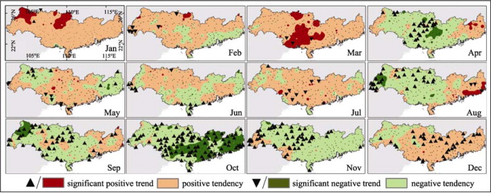
A distinct number of monthly trends of total precipitation, maximum consecutive-5-day precipitation, and dry days have been observed in the time period 1961–2007 (Fig. 2 ). Only few months show a relatively high number of stations with significant trends. Trends of maximum consecutive-5-day precipitation are similarly to trends of total precipitation, while trends in dry days show different directions. The findings of the Mann-Kendal statistics are visualized in Figure 5 . Focus is given on the months with significant trends only.
|
|
|
Figure 5. Monthly trends (Mann-Kendall statistics) of maximum consecutive-5-day precipitation (shadings) and dry days (triangles) in the Zhujiang River Basin (1961–2007) |
January and March host the highest number of stations (33 and 45) with significant positive trends in maximum consecutive-5-day precipitation (Fig. 5 , dark red shadings). These stations can be found in the center and northwest of the basin. Practically all stations have positive tendencies, but with a spatial focus in the center of the basin. No general increasing or decreasing trend of dry days can be detected in January and March (Fig. 5 , upward/ downward triangles).
In October, 77 of 192 stations (40%) show significant negative trends of maximum consecutive-5-day precipitation, which are mostly located in the eastern half of the Zhujiang River Basin (Fig. 5 , dark green shadings). This pattern corresponds strongly to the significant positive trends of dry days in this month. Here, 123 stations (64%) experienced a significant positive trend of dry days (Fig. 5 , upward/downward triangles). The stations with positive trends of dry days are distributed over the entire basin, though the density decreases in the Northwest.
3.3. Relation of large-scale circulation and precipitation extremes in October
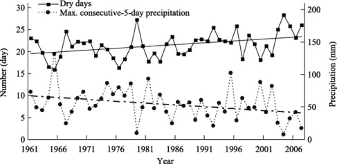
On the basis of the observed trends in precipitation in October, a further decrease (total and max. consecutive-5-day) and increase (dry days) in the future can be assumed. The large-scale circulation (direction and speed) and relative humidity pattern (percentage, at 850 hPa) in East Asia are analyzed. Figure 6 shows the basin averaged annual dry days and annual maximum consecutive-5-day precipitation in October. Maximum consecutive-5-day precipitation is decreasing and the number of dry days is increasing. The October of 1967, 1979, 1992, 2004 and 2007 are considered as exemplary dry months because of their very low precipitation records (around 25 dry days, and less than 25 mm in maximum consecutive-5-day precipitation). On the other hand, the October of 1965, 1976, 1981, 2000, and 2002 are exemplary wet months (less than 20 dry days and more than 75 mm in maximum consecutive-5-day precipitation).
|
|
|
Figure 6. Number of dry days (squares, continuous line) and maximum consecutive-5-day precipitation (circles, dotted line) in October (1961–2007) in the Zhujiang River Basin, and linear tendencies (straight lines, based on linear regression analysis) |
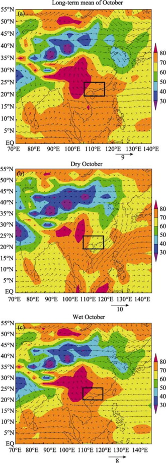
The large-scale circulation patterns in October are shown in Figure 7 . The long-term mean humidity and wind (direction and speed) in October (Fig. 7 a) can be compared with the patterns for dry October (composition of the October pattern in 1967, 1979, 1992, 2004, and 2007; Fig. 7 b) and for wet October (composition of the October pattern in 1965, 1976, 1981, 2000, and 2002; Fig. 7 c).
|
|
|
Figure 7. Characteristics of relative humidity (shadings) and winds (arrows) at 850 hPa level for the long-term mean of October (a), for dry October (b), and for wet October (c), in the Zhujiang River Basin (black square) |
Looking at the long-term mean, a large area of relative humidity above 80% can be found over Southwest China, west of the Zhujiang River Basin. During dry October, this area of relative humidity above 80% is much smaller, while during wet October it is of similar extent as for the long-term mean. Over the Zhujiang River basin the humidity varies between 70% and 80% in both the long-term mean and wet October, while it ranges between 60% and 70% in dry October. The lower amounts can explain the dry weather situation.
In the long-term mean, the Zhujiang River Basin experiences east/northeast winds in October. Reason is a confluence of northeast winds blowing from the Bohai Sea and easterlies from the East China Sea. In dry October, the main winds come from north/northeast with considerably higher wind speeds. They carry little water vapor as they originate from North China’s land masses. During wet October, the main winds come from east/southeast. They probably carry higher amounts of water vapor as they pass mainly over open water (West Pacific). It is obviously that the circulation patterns of dry October differ much more from the long-term mean as the patterns of wet October.
4. Discussion and Conclusions
A significant increase of mean temperature by averagely 0.2 °C per decade has been observed in all months (except for May) for the Zhujiang River Basin (1961–2007). The maximum mean temperature increased by averagely 0.2 °C per decade (with higher differences among the stations). Most compellingly are the increases in mean temperature by up to 0.7 °C per decade along the coastline. The findings on monthly basis are in line with results by Fischer et al. [2010] who found a total increase of annual mean temperature by more than 0.7 °C for the same time-period and byLiu et al. [2009] and Zhai et al. [1999] who worked on seasonal basis. The risk of heat waves and droughts can therefore be assumed.
Significant trends and general tendencies of monthly precipitation indicators can be detected. Precipitation increased from January to March and decreased from September to November. Precipitation pattern in October show the most distinct trends to a dryer climate. This finding is supported by the results of various authors [ Zhai et al., 2005 , Zhang et al., 2009b , Liu et al., 2009 , Yang et al., 2010 and Gemmer et al., 2010 ]. In general, these studies reported increases in winter precipitation and negative trends in autumn precipitation. However, the current study displays observed trends and tendencies of climate extremes in much higher temporal and spatial detail.
Dry or wet conditions in October (around 25 or below 20 dry days, and less than 25 mm or more than 75 mm in maximum consecutive-5-day precipitation) can be explained by large-scale circulation pattern which influences the onset and the strength of the East Asian Winter Monsoon [ Gemmer et al., 2010 , Jhun and Lee, 2004 and Zhu et al., 2005 ]. Conclusively, an early onset and/or strong East Asian Winter Monsoon can be the determining factor for dry conditions in October. Tendencies in precipitation extremes of the Zhujiang River Basin might indicate a shift of the onset and strength of the East Asian Winter Monsoon, but this is still subject to intensive future research.
The observed increases in temperature especially at stations along the coast, in the delta and near urban areas might be influenced by the hot island effect due to urbanization and industrialization, which is an interesting research field but not subject of this paper. No matter why changes in temperature and precipitation occurred, the results give reasons to enhance climate change adaptation and disaster management. The increasing number of dry days and negative trends in precipitation in autumn support the occurrence of droughts, while opposite trends in winter/spring might impede flood risks as more water gets accumulated before the Monsoon season starts (May/June). In future, the vulnerability to drought events, heat waves and flooding will be of main concern [ Zhai et al., 1999 and Zhai et al., 2005 ; Zhang et al., 2009a and Zhang et al., 2009b ; Gemmer et al., 2010 and Fisher et al., 2010 ] as the Zhujiang River Basin is (for example) subject to increasing population density and ongoing industrialization.
Acknowledgements
This study was supported by the National Basic Research Program of China (973 Program) (No. 2010CB428401), the Special Fund of Climate Change of the China Meteorological Administration (CCSF-09-16) and by the National Natural Science Foundation of China (40910177). The positions of Thomas Fischer and Marco Gemmer at the National Climate Center are supported by the German Development Cooperation through the Center for international Migration and Development (www.cimonline.de ).
References
- Alexandersson, 1986 H. Alexandersson; A homogeneity test applied to precipitation data; J. Climatol., 6 (1986), pp. 661–675
- Buishand, 1982 T.A. Buishand; Some methods for testing the homogeneity of rainfall records; J. Hydrol., 58 (1982), pp. 11–27
- Ding et al., 2007 Y. Ding, G. Ren, G. Shi, et al.; China’s national assessment report on climate change (I): Climate change in China and the future trend; Adv. Clim. Change Res., 3 (2007), pp. S1–S5
- Fisher et al., 2010 T. Fisher, M. Gemmer, L. Liu, et al.; Temperature and precipitation trends and dryness/wetness pattern in the zhujiang River Basin, South China, 1961–2007; Quaternary International (2010) http://dx.doi.org/10.101b/j.quaint.2010.08.010
- Gemmer et al., 2004 M. Gemmer, S. Becker, T. Jiang; Observed monthly precipitation trends in China 1951–2002; Theor. Appl. Climatol., 77 (2004), pp. 39–45
- Gemmer et al., 2010 M. Gemmer, T. Fischer, T. Jiang, et al.; Trends of precipitation extremes in the Zhujiang River Basin; South China. J. Climate. doi: (2010) http://dx.doi.org/10.1175/2010JCLI3717.1
- Jhun and Lee, 2004 J. Jhun, E. Lee; A new East Asian winter monsoon index and associated characteristics of the winter monsoon; Amer. Meteor. Soc., 17 (2004), pp. 711–726
- Kalnay et al., 1996 E. Kalnay, M. Kanamitsu, R. Kistler, et al.; The NCEP/NCAR 40-year reanalysis project; Bull. Amer. Meteor. Soc., 77 (1996), pp. 437–470
- Liu et al., 2008 Q. Liu, Z. Yang, B. Cui; Spatial and temporal variability of annual precipitation during 1961–2006 in Yellow River Basin; China. J. Hydrol., 361 (2008), pp. 330–338
- Liu et al., 2009 L. Liu, T. Jiang, F. Yuan; Observed (1961–2007) and projected (2011–2060) climate change in the Pearl River Basin; Adv. Clim. Change Res. (in Chinese), 5 (4) (2009), pp. 209–214
- Peterson et al., 1998 T.C. Peterson, D.R. Easterling, T.R. Karl, et al.; Homogeneity adjustments of in situ atmospheric climate data: A review; International Journal of Climatology, 18 (1998), pp. 1493–1517
- Song et al., 2004 F. Song, Q. Hu, W. Qian; Quality control of daily meteorological data in China, 1951–2000: A new dataset; International Journal of Climatology, 24 (2004), pp. 853–870
- Yang et al., 2010 T. Yang, Q. Shao, Z. Hao, et al.; Regional frequency analysis and spatio-temporal pattern characterization of rainfall extremes in the Pearl River Basin; China. J. Hydrol., 380 (3–4) (2010), pp. 386–405
- Zhang et al., 2007 J. Zhang, Y. Wang, Z. Wang; Change analysis of land surface temperature based on robust statistics in the estuarine area of Pearl River (China) from 1990 to 2000 by landsat TM/ETM + data; Int. J. Remote Sens., 28 (10) (2007), pp. 2383–2390
- Zhang et al., 2009a Q. Zhang, C. Xu, Z. Zhang; Trends and abrupt changes of precipitation maxima in the Pearl River basin, China; Atmospheric Science Letters, 10 (2) (2009), pp. 132–144
- Zhang et al., 2009b Q. Zhang, C. Xu, S. Becker, et al.; Observed changes of drought/wetness episodes in the Pearl River basin, China, using the standardized precipitation index and aridity index; Theor. Appl. Climatol., 98 (2009), pp. 89–99
- Zhai et al., 1999 P. Zhai, A. Sun, F. Ren, et al.; Changes of climate extremes in China; Climatic Change, 42 (1999), pp. 203–218
- Zhai et al., 2005 P. Zhai, X. Zhang, H. Wan, et al.; Trends in total precipitation and frequency of daily precipitation extremes over China; J. Climate, 18 (2005), pp. 1096–1108
- Zhai et al., 2009a J. Zhai, B. Su, V. Krysanova, et al.; Spatial variation and trends in PDSI and SPI indices and their relation to stream flow in 10 large regions of China; J. Climate (2009) http://dx.doi.org/10.1175/2009JCLI2968.117
- Zhai et al., 2009b J. Zhai, B. Liu, H. Hartmann, et al.; Dryness/wetness variations in China during the first 50 years of the 21st century; Hydrol. Earth Syst. Sci. Discuss., 6 (2009), pp. 1385–1409
- Zhu et al., 2005 C. Zhu, W. Lee, H. Kang, et al.; A proper monsoon index for seasonal and interannual variations of the East Asian monsoon; Geophys. Res. Lett., 32 (2005) L02811
Document information
Published on 15/05/17
Submitted on 15/05/17
Licence: Other
Share this document
Keywords
claim authorship
Are you one of the authors of this document?

