Abstract
Debris treatment after earthquake is very important matter especially after large-scale disasters. Efficient debris treatment is leading to faster reconstruction. Particularly, this article examines fuzziness in debris treatment planning. The problem reduces to a standard transport problem by fundamental formulation. A fuzzy debris transport problem for supply and demand formulated fuzzy constraints. A problem-solving algorithm by referring numerical example demonstrates an irrelevant approach. Realistic debris transport planning can be defined by using the recommended method.
Keywords: Fuzzy transport problem, debris treatment, earthquake
1. Introduction
Among all the dangerous matters that threaten life of human, in particular cities are threatening by natural disasters such as floods, earthquakes and volcanoes. Considering the geophysical and technological situation of Iran and its location that is one of the most earthquake-prone parts of the world, this led to the country's continuing counter with the natural phenomenon of earthquakes. Therefore, it is essential to take measures for obtaining accurate methods and strategies to logically confront such an event and minimize its side effects [1]. At the time of earthquakes occurrence, the demand and need for essential and diverse resources and equipment rises. The most important issue in crisis management is transferring the injured people to a safe place in the shortest possible time [2]. Many elements, such as obtaining accurate information from the scene of the accident, the type and amount of required resources, the preparation of the required resources and finally determining a safe route for transportation can be very effective in this phenomenon [3]. Not paying attention to the critical problems is leading to lack of identification in affected points (nodes) and the proper path between these nodes, not minimizing the relief time that causing problems such as increased accidents for the injured and patients as a result of water shortages, medicine and food and lack of shelter for possible aftershocks. Lack of attention to these issues, increases the number of casualties. A shortage of comprehension of the debris management process often prevent the response and recovery phases of disaster debris. Some of these aspects consist: funding mechanisms, responsible offices, and the role of the residents in debris separation. Crisis management is a term that contains all dimensions of crisis planning and crisis-related planning, such as pre and post-crisis activities and measures that is also handles both the risks and consequences of the crisis [4]. Crisis management is a process that has four-step: risk reduction, preparedness, response, and improvement. Taking strategic measures reduces the risk of disaster and eliminates its effects. Dealing with the earthquake debris is more challenging issues than the earthquake itself. Inaccurate information about the facilities, the potentials of the region, and the composition of the generated debris will causing more problem and delay in providing service, such as public dissatisfaction, and have irreparable environmental, economic and social effects in long term [5]. Although debris management are involve in all related environmental issues, pre-accident planning and preparedness for an earthquake that unfortunately did not received enough attention in Iran [6]. In this regard, planning must consider laws and environmental guidelines, which during the accident facilitate the debris removal [7]. Estimation of the debris caused by an accident is a complicated task because numerous variable points should be taken into consideration and the assessment range can vary from a small amount of debris to thousands of tonnes [8]. Selecting a landfill site for earthquake wastes is also important because if it is not wisely selected beforehand, cleaning of the city’s passages will be delayed during the critical conditions following the accident.
The earthquake that happened on 26 March 2003 caused huge damages and has high number of casualties. When such a disaster-stricken area is reconstructed, for early reconstruction an immediate debris disposal treatment is very necessary. It is essential to take an impressive basic procedure for the debris disposal treatment for large-scale disasters such as Bam earthquake and so on. So, a debris disposal treatment problem is formulated as a transport problem for various reasons. For large-scale earthquakes experience of the debris treatment is not enough because such a treatment is not generally discovered and the volume of debris in the disaster might be estimated without certainty.
Moreover, the speed of debris processing cannot introduce fixed number very well. In this regard, the debris treatment planning of large-scale earthquakes involves in many uncertainty and inaccurate factors [9]. In this article, fuzzy debris treatment demand and fuzzy capacity of debris processing are discovered as high uncertain elements. In addition, fuzzy transport problem is aimed to review the fuzziness of debris treatment.
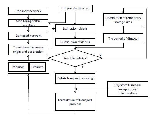
The flow chart of the debris disposal treatment is shown in Figure 1. In according to this flow chart, the amount of disposed debris is estimated and a transport plan is considered. The key points of debris processing include the following contents: (1) pre-selecting the location of the debris processing site; (2) re-estimation of the debris quantity; (3) appropriate arrangement of the location of the debris processing site; and (4) the real-time monitoring the road-traffic environment.
|
| Figure 1. Flowchart of debris disposal treatment |
2. Literature review
When the natural disasters are happening, having a place for temporary stacking of the debris and wastes is required, which could be useful due to some problems such as full burial sites and insufficient removal/ transportation equipment [10-12]. Using temporary stacking sites decreases the costs of debris removal and waste cleaning [13]. In fact, the debris are transferred twice; once from the accident area to the temporary stacking site and then from there to the final burial site [14]. Rodríguez et al. (2006) reviewed and designed earthquake emergency routes in the United States [15]. Their report analyses the behavior and destruction of the buildings in previous earthquakes and studied the related guidelines for designing safer buildings. In addition, they studied various methods for vulnerability evaluation and for estimation of building damages with an emphasis on roads, soil behavior and site effect. The earth’s movements effects, soil liquefaction and slip on the transportation system were taken into consideration simultaneously. Hu and Sheu studied economic damages caused by an earthquake, including the damage entered on the bridges and the making delay in travelling [16]. Inui et al. considered San Fernando Bay to study the site effects on bridges and discussed a 7.0 magnitude earthquake scenario in Hayward Fault as a fundamental for analysing the effects of (vertical/ horizontal) displacement and acceleration [17]. Fujino and Noguchi introduced a method for estimation of destruction debris and assessment of available options for debris management in Tokyo [18]. Nouri et al. studied the useable methods for monitoring the generation of destruction debris in building sites. They concluded that some parts of administrative and educational buildings used as storage for hazardous and flammable materials are might lead to many disasters [19]. More recently for schools and kindergartens a new citizenship HSE model is introduced in Tehran to decrease the hazards of incidences in educational centers [20]. Wang and Hu, by using a statistical model estimated the amount of generated destruction debris. Brown et al. examined the debris generated by destruction and construction concentrating on the mass balance of the elements in a separation program [21]. Karta et al. make lot of effort to analyze the generation sources, estimating the destruction and construction debris, as well as the process of debris management in Greece [22]. Ozdamar et al. for transportation of equipment’s in a crisis introduced a path-finding model [23]. Omidvar et al. utilized a wise solution to solve the problem and compared the efficiency of the model with the data that obtained from the Izit earthquake in Turkey [24]. Another study revealed that the most significant challenge in an evacuation operation, most of the time are the exit routes that are not sufficient and safe in number and capacity to support the sudden surge in traffic [25]. They stated that the capacity of the transportation network in a crisis is usually insufficient to support the transportation and cannot meet the demands during the evacuation. Tam et al. [26] were studied the direct and indirect costs calculation in national scale and the interactions between private sectors. Most of the researches compute the costs of damage to the buildings and highway networks but they cannot show how different systems affect each other by damage intensification [27]. Leem and Rhee [28] in their studies used the shortest-path algorithm (SPA) for evacuation path determination after incidents such as earthquakes, storms or chemical explosions. Some researchers have attempted to discover the optimized path for the debris transport from the network design point of view [29]. Moreover, Stepanov and Smith et al. [30] reviewed the design and analysis of the evacuation routes in transportation networks and recommended a method for finding the best route. Chang et al. [31] also tried by formulating the emergency evacuation problem rebuild the rescue and relief network. Most of the efforts that have been done for estimation of post-earthquake debris were limited. TELES, RISKUE and RADUIS are some of the models introduced for prediction and estimation of vulnerability to earthquake.
3. Analytical methods
Khorramabad city is the capital of Lorestan province and the 23rd most populous city in Iran. According to the 2016 census of the Statistics Center of Iran, the population of Khorramabad was 506,471. The city is located at an altitude of 1147.8 meters above sea level and in the valleys of the Zagros. The distance from Khorramabad to Tehran is 490 km and due to its location on the Tehran-South route has high importance of communication and strategic matters. Iran Freeway No. 5 passes through this city.
In accordance to the transport plan, the debris processing method is modeled. The structure of debris processing and debris transport model is studied for this purpose. Moreover, the amount of debris and transport cost is setting.
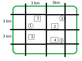
Figure 2 demonstrates the overall debris processing method. The key parameters of debris processing are modeled. The following assumptions were considered for problem setting in Figure 2.
- The change in the road traffic condition in accordance to time is not taking into account.
- The spatial arrangement of the debris processing site is done completely.
- The difference between the temporary storage site and the debris processing site is not regarded.
- The effect of other processes of debris processing is not gained attention.
According to these assumptions, the structure of the debris processing model was formulated. In this paper, the debris processing of one city was modeled. Figure 2 demonstrates the spatial distribution of debris processing. The green line is the sign of city borderline and black line is the sign road network as well.
There are three debris generation points indicated as ![]() ,
, ![]() ,
, ![]() in the figure. The squares in Figure 2 represented four debris processing sites.
in the figure. The squares in Figure 2 represented four debris processing sites.
|
| Figure 2. The units of debris processing |
3.1 Debris transport model
Transport efficiency is fundamental for debris processing and its purpose is to minimizing the transport cost for the debris transport site debris. Therefore, through the following equations the transport plan can be formulated.
|
|
(1) |
Here, and shows the transport cost per tons and the transport volume from area to the processing site , respectively; represents the amount of debris to be processed in area (tons/month); and represents the capacity of the processing site (tons/month).
The amount of debris processed per month and the capacity of the processing site was arranged so that by passing 30 months the processing can be completed. Under these limitations, it is decided to use transport plan for decreasing the transport cost.
3.2 Determine the amount of debris
The parameter determinations of the debris processing model are the amount of debris in each area, the capacity of each processing site, and the transport cost. Here, one city with three areas is modeled. Debris disposal processing is expected to usually complete within two years. In this paper, we aimed to calculate the volume of debris in each area per month to meet the deadline and complete the debris processing (Table 1). This content divided the volume of debris by the number of months to process the debris.
| Area 1 | Area 2 | Area 3 | Total |
|---|---|---|---|
| 5500 | 5800 | 4850 | 16150 |
It is proposed that the efficiency of processing site related to the capacity of storage. Thus, capacity of storage in the processing site is shown in Table 2. Various capacities of processing sites are designed contributing to the different contents of disaster debris.
In the disaster, before the processing referred to the estimated volume of debris, the capacity of processing site must be identified. So, as mentioned before, the amount of removed debris from the damaged site should be equal to the total processing volume. It is a usual limitation between demand and supply in transport problem.
| Site 1 | Site 2 | Site 3 | Site 4 | Total |
|---|---|---|---|---|
| 7100 | 6850 | 6400 | 6300 | 26650 |
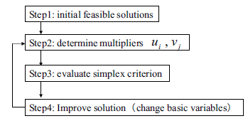
In the model it is assumed that the debris transport planning is created each month referring to total volume of processed debris. This paper represents many useful conventional techniques that one of them is debris. In the study, the conventional technique such as Modified Distribution (MODI) method is used to solve the transport problem. Figure 3 represents the calculation process of the transport problem in the MODI method.
|
| Figure 3. Algorithm of transport problem |
Fuzzy logic is a mathematical tool that deals with uncertainty in a different way and is a method of “approximating modes of reasoning” [32] that can relate independent variables to dependent variables. Zadeh introduced variables to dependent variables [33] and discussed that fuzzy set theory representing the boundary that is not precise and the gradual transition is expressed by a membership function, and it changes from non-membership to membership in a fuzzy set (Eq. (4)). The characteristic function value ranges between 0 and 1. Each membership function is represented by a curve that shows the assignment of a membership degree in a fuzzy set to each value of a variable [34]. Curves of the membership functions can be linear, triangles, trapezoids, bell-shaped, or more complicated shapes (Figure 3) based on the objective of the subject [35]
|
|
(2) |
where is called the a-cut or a-level set of , and expresses membership degree of the element . Fuzzy systems are mostly working in accordance with expert knowledge to formalize reasoning in natural language mainly using sets of fuzzy inference rules or “if–then” rules (Eq. (2))
|
(3) |
As membership function curves by small increments can easily be changed based on expert knowledge, fuzzy logic then can characterize and model geologic systems in an efficient and useful way [36]. As mentioned beforehand, earthquake disaster is considered as an uncertain event that nobody knows when it is occurring. So, many fuzzy elements must be regarded in the debris transport planning. Especially, the processing demand of debris and the capacity of the processing site cannot be defined very accurately. In addition, the fuzzy transport problem can be come along with membership functions as the volume of debris of each area to the capacity of the debris processing site.
The membership functions are recognized as follows:
|
|
(4) |
The total cost can be discussed in terms of disaster debris treatment and it is commonly paid by the government because of natural disaster. As the total cost cannot be determined very accurately, the upper limit of the national budget to debris transport is assumed.
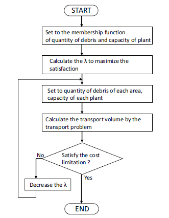
Figure 4 shows the solution process of the fuzzy transport problem. The value of ð should be updated to maximize with the limits that the total cost cannot exceed to the budget. At the same time, the value of ð is updated as well as processing demand of debris and the capacity of processing site that is described by the membership functions. Finally, the travel pattern of debris transport on the network is presented as a result of calculation.
|
| Figure 4. Flowchart of the fuzzy transport problem |
The membership functions for processing debris demand are originally shown in Figure 5. The membership function shows the linguistic number as “greater than” processing demand. Thus, each membership function is expressed diagonally right up. The grade of membership function is relates to the satisfaction level that the value is originally greater than the debris processing demand.
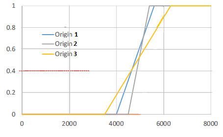
|
| Figure 5. Membership function of the volume of debris in each area (one month) |
The value of ð is computed by equating the volume of debris and the capacity of the processing site. In the range of ð , the volume of debris in area 1 is formulated as ð. Similarly, the volume of debris of each area is formulated by a function of ð. The total volume of debris in all areas is ð. The capacity of processing site 1 is formulated as ð. The total capacity of all processing sites is calculated ð. ð that the volume of debris is equivalent to the capacity of a processing site.
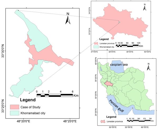
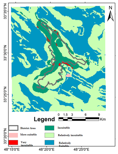
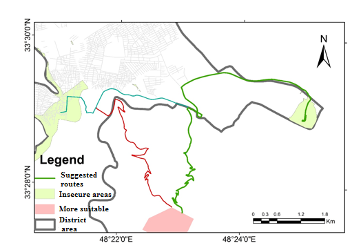
In order to evacuate and temporarily deposit the structural debris, the arid land sites located at the Khorram abad City were shown in (Figure 6). In selection of the routes, with the lot of attempt, the safest and fastest routes have been selected. The maximum amount of time to arrive at the target sites is 32 m and the longest displacement is 18.61 Km. Given to the extents and limits of debris removal, and cleaning and reopening of the routes, the routes must be as short as possible.
|
| Figure 6. Geographical location of the case study of Khorram abad City, Iran |
Therefore, the centers of gravity in the regions of Khorram abad City were selected as the starting points (Figures 7 and 8) and their coordinates were recorded by a GPS device to be examined in the GIS environment. By using auto-map software, the requested maps were modified and prepared in different layers. With this method, the geographical system database was storaged in different layers and was used with the aid of GIS analysis for three major analyses: a) Finding the best route, b) Locating the nearest site, and c) determining the service range. The new concern for municipalities is the management of structural debris and wastes (Figure 9).
|
| Figure 7. Distribution of depot locations for the debris in Khorram abad City |
|
| Figure 8. The best way to move construction debris to the right place for storing debris |
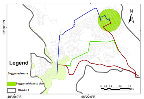
|
| Figure 9. Debris evacuation routs in Khorram abad City |
By accepting the matter that the data and useful information on debris management are insufficient, the data obtained in this matter can be a significant source of feedbacks for the estimation of the amount of debris and wastes. All of the experiences that gained can be useful for better preparedness, facilitation of the reconstruction operations, and aid operations with fewer costs during a natural disaster in future. Given to the time required for loading and transportation between the cleared areas and the selected depot sites, each truck would be able to perform 8 services per 24 h to carry 50 m3 that this should be considered in estimating the required equipment for debris evacuation.
Conclusions
Wise measures should be taken to reduce the total costs and response time as well as facilitating the debris removal operation and management. For example, the costs of debris removal and evacuation should be estimated beforehand and proper financial methods should be regarded. Before the occurrence of disaster, the volume of debris and the needed machinery for its transport to a proper place must be estimated well. It is very crucial to find suitable locations for disposal of demolitions. Also, it is very essential to force the owners of vulnerable buildings to strengthen the structures of their building before any incidence occurrence. Appropriate measures should be taken for eliminating the hazardous waste after earthquake occurrence. Before any incident estimating the composition of debris can help mangers to come up with the appropriate machinery needs. Municipality of Khorram abad City should come into contract with the owners of heavy machineries well before any incident. The contract may provide some tax decrease to the owners of heavy machineries during the years before earthquake incidence and in turn they help the municipality to transport debris on free charges. This paper discusses fuzziness in disaster debris transport problem. Especially, the transport problem with fuzzy objective and fuzzy limitations is formulated to acknowledge the improvements of practical debris transport policy. The most important discoveries of this paper summarized as follows:
- Uncertain elements in the disaster debris transport problem are summarized to make the influential transport plan even in the unexpected natural disaster. Particularly, the fuzzy processing demand of debris and fuzzy capacity of processing site are described by fuzzy transport problem.
- The algorithm to solve the fuzzy debris transport problem is recommended with numerical examples. It is acknowledged that fuzzy decision between fuzzy objectives and fuzzy limitations provide the debris travel patterns between origins and destinations.
- In terms of the transport cost, the budget would be regarded. As the constraint of transport cost is entered, the different debris transport patterns are proposed through the algorithm of fuzzy transport problem.
Acknowledgement
This study was supported by Science and Research Branch, Islamic Azad University of Tehran.
References
[1] Arai Y., Ikeda Y., Inakazu T, Koizumi A., Mogi S., Yoshida S. Model analysis of transportation planning for earthquake disaster debris – Issues relating to temporary storage space. Journal of Japan Society of Civil Engineers, 71:263-271, 2015.
[2] Askarizadeh L., Karbassi A.R., Ghalibaf M.B., Nouri J. Management of post-earthquake construction debris in Tehran Metropolitan. Int. J. Environ. Sci. Tech., 13(2):639-648, 2016.
[3] Fujino Y., Takada T. Risk assessment, management and monitoring of infrastructure systems. In: Fujino Y., Noguchi T. (eds) Stock Management for Sustainable Urban Regeneration, 4:233-253 Springer, Tokyo, 2009.
[4] Meslem A., Yamazaki F., Maruyama Y. Accurate evaluation of building damage in the 2003 Boumerdes, Algeria earthquake from QuickBird satellite images. Journal of Earthquake and Tsunami, 5(01):1-18, 2011.
[5] Riahi A., Sadeghi H., Hosseini S.K. Simulation of 2003 Bam (Iran) earthquake using empirical Green's function method via very small and near-fault events. Geophysical Journal International, 201:1264-1286, 2015.
[6] Eshghi K., Najafi M. A logistics planning model to improve the response phase of earthquake. International Journal of Industrial Engineering & Production Management, 4:401-416, 2013.
[7] Edrissi A., Poorzahedy H., Nassiri H., Nourinejad M. A multi-agent optimization formulation of earthquake disaster prevention and management. European Journal of Operational Research, 229(1):261-275, 2013.
[8] Hamani A., Boudjema L. A generic model helps to transit from crisis management to natural disasters risk management and stabilize sustainable development, Energy Procedia, 36:977-984, 2013.
[9] Huang M., Smilowitz K.R., Balcik B. A continuous approximation approach for assessment routing in disaster relief. Transportation Research Part B: Methodological, 50:20-41, 2013.
[10] Karbassi A.R., Shahpasand M., Rajabi A.A., Ghafari H.A. Development of new citizenship HSE model for schools and kindergartens of Tehran Metropolitan City. Int. J. Human Capital Urban Manage., 1(1):19-30, 2016.
[11] Leem Y., Rhee S. An efficient dissimilar path searching method for evacuation routing. KSCE J. Civil Eng., 14:61-67., 2010.
[12] Nouri J., Mansouri N., Abbaspour M., Karbassi A.R., Omidvari M. Designing a developed model for assessing the disaster induced vulnerability value in educational centers. Safety Sci., 49(5):679-685, 2011.
[13] Omidvar B., Golestaneh M., Abdollahi Y. A framework for post-earthquake rapid damage assessment of hospitals. Case study: Rasoul-e-Akram Hospital, Tehran, Iran. Environ. Hazards, 13(2):133-160, 2014.
[14] Ozdamar L., Tuzun Aksu D., Erguneş B. Coordinating debris cleanup operations in post disaster road networks. Soc. Econ. Plann. Sci., 48(4):249-262, 2014.
[15] Pramudita A., Taniguchi E., Gul Qureshi A. Location and routing problems of debris collection operation after disasters with realistic case study. Procedia Soc. Behav. Sci., 125:445- 458, 2014.
[16] Rodríguez G., Alegre F.J., Martínez G. The contribution of environmental management systems to the management of construction and demolition waste: The case of the Autonomous Community of Madrid (Spain). Resour. Conserv. Recycl., 50(3):334-349, 2007.
[17] Zhou C., Liu X., Wang Z., Yang T., Shi L., Wang L., Cong L., Liu X., Yang, J. Marine debris surveys on four beaches in Rizhao City of China. Global J. Environ. Sci. Manage., 1(4):305-314, 2015.
[18] Stepanov A., Smith J.M. Multi-objective evacuation routing in transportation networks. European J. Operation. Res., 198:435-446, 2009.
[19] Hekimoglu Y., Esen Melez I., Canturk G., Erkol Z., Canturk, N., Gokhan Dizdar, M., Oguzhan Melez D., Nuri Guler O. Evaluation of the deaths secondary to entrapment under the debris in the Van earthquake. Egyptian Journal of Forensic Sciences, 3:44-47, 2013.
[20] Hu Zh-H., Sheu J-B. Post-disaster debris reverse logistics management under psychological cost minimization. Transport. Res., Part B: Methodological, 55:118-141, 2013.
[21] Inui T., Yasutaka T., Endo K., Katsumi T. Geoenvironmental issues induced by the 2011 off the Pacific Coast of Tohoku Earthquake and tsunami. Soils Foundations, 52(5):856-871, 2012.
[22] Jenelius E. Approaches to road network vulnerability analysis. Licentiate thesis in infrastructures with specialization transport and location analysis. Royal Institute of Technology, Stockholm, Sweden, 2007.
[23] Askarizadeh L., Karbassi A.R., Ghalibaf M.B., Nouri J. Management of post-earthquake construction debris in Tehran Metropolitan. Int. J. Environ. Sci. Tech., 13(2):639-648, 2016.
[24] Brown C., Milke M., Seville E. Disaster waste management: A review. Waste Manage., 31(6):1085-1098, 2011.
[25] Wang C.Y., Hu S.R. A study on emergency evacuation and rescue network reconstruction for natural disasters with multiclass travel behavior constraints. J. East. Asian Soc. Transport Stud., 6:4269-4284, 2008.
[26] Tam V.W., Tam C.M. A review on the viable technology for construction waste recycling. Resour. Conserv. Recycl., 47(3):209-221, 2006.
[27] USAID. Making cities work: USAID’s urban strategy, an Initiative launched by the Administrator and prepared by the Urbanization task force, 2001.
[28] Leem Y., Rhee S. An efficient dissimilar path searching method for evacuation routing. KSCE J. Civil Eng., 14(1):61-67, 2010.
[29] Wang C.Y., Hu S.R. A study on emergency evacuation and rescue network reconstruction for natural disasters with multiclass travel behavior constraints. J. East. Asian Soc. Transport Stud., 6:4269-4284, 2008.
[30] Stepanov A., Smith J.M. Multi-objective evacuation routing in transportation networks. European J. Operation. Res., 198(2):435-446, 2009.
[31] Chang L., Elnashai A.S., Spencer B.F. Post-earthquake modelling of transportation networks. Structure Infrastructure Eng., 8:893-911, 2011.
[32] Zadeh L. Fuzzy sets. Information and Control, 8(3):338–353, 1965.
[33] Zadeh L.A. The concept of linguistic variable and its application to approximate reasoning. Information Sciences, 8:199–249, 1975.
[34] Singh H., Gupta M.M., Meitzler T., Hou Z.-G., Garg K.K., Solo A.M.G., Zadeh L.A. Real-life applications of fuzzy logic. Advances in Fuzzy Systems, 2013, 581879, 2013.
[35] Meshkini A, Habibi K., Alizadeh H. Using fuzzy logic and GIS tools for seismic vulnerability of old fabric in Iranian cities (Case study: Zanjan city). Journal of Intelligent & Fuzzy Systems, 25(4):965-975, 2013.
[36] Nordlund Ulf. Formalizing geological knowledge with an example of modeling stratigraphy using fuzzy logic. Journal of Sedimentary Research, 66:689-698, 1996.
Document information
Published on 03/01/22
Accepted on 02/01/21
Submitted on 27/09/20
Volume 38, Issue 1, 2022
DOI: 10.23967/j.rimni.2021.12.003
Licence: CC BY-NC-SA license
Share this document
claim authorship
Are you one of the authors of this document?