Abstract
Based on observed daily precipitation data of 540 stations and 3,839 gridded data from the high-resolution regional climate model COSMO-Climate Limited-area Modeling (CCLM) for 1961–2000, the simulation ability of CCLM on daily precipitation in China is examined, and the variation of daily precipitation distribution pattern is revealed. By applying the probability distribution and extreme value theory to the projected daily precipitation (2011–2050) under SRES A1B scenario with CCLM, trends of daily precipitation series and daily precipitation extremes are analyzed. Results show that except for the western Qinghai-Tibetan Plateau and South China, distribution patterns of the kurtosis and skewness calculated from the simulated and observed series are consistent with each other; their spatial correlation coefficients are above 0.75. The CCLM can well capture the distribution characteristics of daily precipitation over China. It is projected that in some parts of the Jianghuai region, central-eastern Northeast China and Inner Mongolia, the kurtosis and skewness will increase significantly, and precipitation extremes will increase during 2011–2050. The projected increase of maximum daily rainfall and longest non-precipitation period during flood season in the aforementioned regions, also show increasing trends of droughts and floods in the next 40 years.
Keywords
kurtosis distribution ; skewness distribution ; daily precipitation pattern ; projected trend ; CCLM ; China
1. Introduction
Climate change affects the water cycle and distribution pattern of water resources by changing the spatial distribution and temporal variation of precipitation [ UNDP , 2006 ]. With increasing global surface temperature, precipitation has increased in many low latitude regions, but it has decreased in most parts of the mid-latitudes, and the rainfall-covered areas have increased in the high latitude regions [ Groisman et al. , 1999 ]. In China, no significant linear trend can be detected for annual precipitation, but the areas with higher precipitation intensity have shown expanding trends [ Zhai et al. , 1999 ]. Precipitations in all seasons have increased in Northwest China and decreased in North China, whereas summer and winter precipitations have shown increasing trends in the middle and lower reaches of the Yangtze River [ Ning and Qian , 2008 ]. Aside from the studies on the trends of annual and seasonal precipitation, researches on the spatial distribution and trends of daily precipitation have been focused on the analysis of rainy days and precipitation extremes [ Fang et al ., 2007 ; Li et al ., 2008 ; Liu and Ding, 2010 ]. Little emphasis has been placed on studying the general distribution characteristics of daily precipitation series and their future trends.
Based on the observed and simulated precipitation data from COMOS-Climate Limited-area Modeling (CCLM) for 1961–2000, the simulation ability of CCLM for daily precipitation in China is evaluated by applying kurtosis and skewness statistic analysis. Projected daily precipitation data from CCLM under SRES A1B scenario for 2011–2050 are used to compare its temporal-spatial distribution characteristics and trends with those in 1961–2000. The maximum daily rainfall and the longest non-precipitation period during flood seasons are used to analyze the future trends and the spatial distribution of extreme precipitations over China for 2011–2050. This research is of great importance for scientifically assessing the impacts of climate change, and also helpful for developing adaption strategies to cope with climate change impacts.
2. Data and methodology
2.1. Data
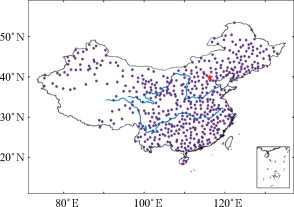
Daily precipitation data for 1961–2000 selected from 540 homogeneously distributed gauge stations in China (Fig. 1 ), provided by National Meteorological Information Center, are used in the present study.
|
|
|
Figure 1. Location of meteorological gauge stations in China |
Gridded daily precipitation dataset from CCLM [ Fischer et al. , 2013 ] was provided by the Potsdam Institute for Climate Impact Research (PIK). It includes daily precipitation data at 3,839 grid points within China in the simulation period of 1961–2000 and projected period for 2011–2050 under SRES A1B scenario. As a dynamical down-scaling regional model, CCLM applies the output of the GCM/OM (ECHAM5) as its boundary conditions, and can simulate time scale up to 100 years with spatial resolution of 0.5°×0.5°. The reason for selecting A1B scenario (IPCC’s moderate emission scenario) in this study is that A1B scenario comparatively conforms with the natural and social- economic sustainable development perspective of China with the assumption of rapid growth of economic condition and development of new efficient technology in the future, and relative equilibrium energy consumption [ Lin and Liu , 2008 ].
2.2. Kurtosis and skewness
To describe the distribution features of daily precipitation and extreme precipitation in China, two statistics, named kurtosis and skewness, are employed in the paper [ Wang, 2008 ; Sheng et al ., 2006 ].
Kurtosis is a dimensionless value used to measure the leptokurtosis of random variables’ probability distribution. Kurtosis > 0, means that the probability distribution is peakedness; kurtosis < 0, means that the probability distribution is platykurtosis. The greater the absolute value of kurtosis, the larger the difference between the form of probability distribution and normal distribution.
Skewness is also a dimensionless value that measures the asymmetry or deflection degree of random variables’ probability distribution. Negative skewness (left skewness) means the probability distribution function’s left tail is longer than its right tail, and most values (include the median value) are on the right side of the mean value. Positive skewness (right skewness) means the probability distribution function’s right tail is longer than the left tail, and most values are on the left side of mean value.
3. Kurtosis and skewness of daily precipitation series
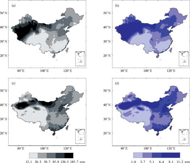
Based on the observed daily precipitation data and CCLM gridded data, the kurtosis and skewness of each station (grid) are calculated. The spatial distribution of their 40-year (1961–2000) mean values are shown in Figure 2 .
|
|
|
Figure 2. Kurtosis (a, c) and skewness (b, d) of observed (a, b) and CCLM simulated (c, d) daily precipitation series for 1961–2000 |
In Figure 2 a, the kurtosis of daily precipitation for every station in China for 1961–2000 is positive, and its value decreases from north to south. High values are located in most part of Northwest China and northwestern Inner Mongolia. Medium values are located in the mid-eastern part of Inner Mongolia, North China and parts of Northeast China. The kurtosis in most parts of southern China is lower, especially in Southeast and Southwest China. Figure 2 b illustrates that the skewness of observed daily precipitation series is also positive without exception, and shows similar spatial distribution pattern to that of kurtosis.
As shown in Figure 2 c and 2 d, the kurtosis and skewness of CCLM gridded daily precipitation are also positive throughout China; the largest values are located in the South Xinjiang Basin and northwestern Inner Mongolia, followed by North China and parts of Northeast China. When they are compared with Figure 2 a and 2 b, it is obvious that the spatial pattern of the kurtosis and skewness from the simulated series are consistent with those of observations, except the western Qinghai-Tibetan Plateau and southern China. The spatial correlation coefficients between Figure 2 c and 2 a, and between Figure 2 d and 2 b, calculated by GIS, both exceed 0.75 (at 95% confidence level), which proves that CCLM model can well capture the distribution characteristics of daily precipitation in China [ Tang and Yang , 2006 ; Su et al. , 2006 ]. CCLM could therefore be a suitable tool for evaluating the spatial-temporal characteristics of precipitation over China in the future.
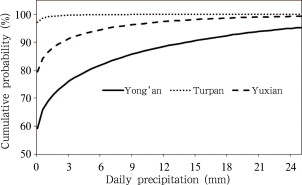
Figure 3 shows the probability distribution of daily precipitation at representative stations, e.g., Turpan station in Northwest China with high kurtosis/skewness, Yuxian station in North China with medium values of kurtosis/skewness, and Yong’an station in Southeast China with low kurtosis/skewness. It is clear that the probability of daily precipitation less than 0.1 mm (non-precipitation days) is 95% in Northwest China, 79% in North China, and 59% in Southeast China, and that the kurtosis is declining with the decreasing of the probability.
|
|
|
Figure 3. Daily precipitation probability at 3 representative stations for different kurtosis and skewness regions for 1961–2000 |
Table 1 shows the probabilities of daily precipitation below or above their mean value at the aforementioned 3 stations which represent different kurtosis and skewness regions, respectively. It can be noted that with the decreasing of skewness, the probability of precipitation above and below the mean values tend to increase. For example, only 4% of daily precipitation is lower than the mean value in Northwest China, and up to 14% in North China and 21% in Southeast China, respectively.
| Representative station | Representative region | Daily precipitation (mm) | Probability at left side (%) (above mean) | Probability at right side (%) (below mean) |
|---|---|---|---|---|
| Turpan | High value region | 0.05 | 96 | 4 |
| Yuxian | Median value region | 1.09 | 86 | 14 |
| Yong’an | Low value region | 4.24 | 79 | 21 |
4. Trends in kurtosis and skewness
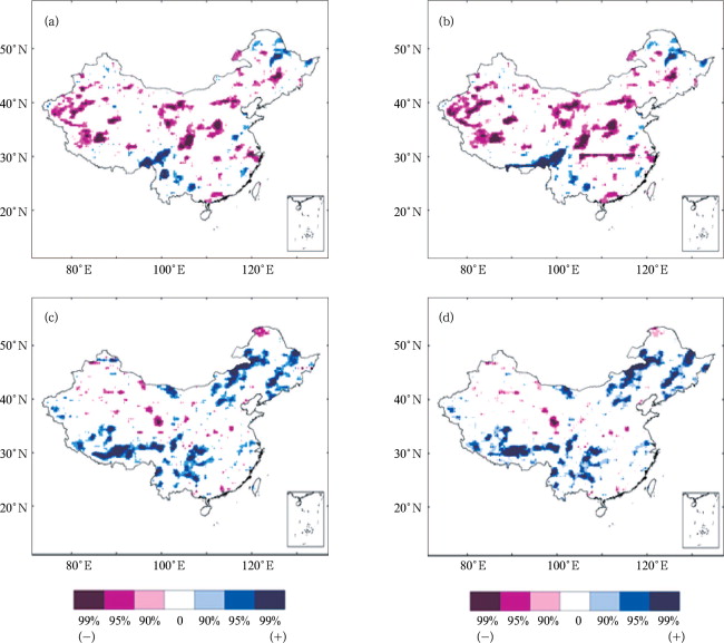
Based on the CCLM simulated and projected data during 1961–2000 and 2011–2050, the Mann-Kendall [ Su et al. , 2006 ] test is applied to detect the trends in kurtosis and skewness of daily precipitation time series. In 1961–2000, precipitation kurtosis of 850 grids has changed significantly. Among them, 350 grids located in Southwest China and northern Northeast China have witnessed obviously increasing kurtosis, and 532 grids located in western Xinjiang, eastern Northwest China, northern and southwestern North China, central Northeast and the Jianghuai region have witnessed decreasing kurtosis (Fig. 4 a). For skewness (Fig. 4 b), 850 grids have changed significantly, among which 295 grids have increased evidently and 565 grids decreased obviously. The spatial distribution of trends in skewness is similar to that of kurtosis (Fig. 4 a).
|
|
|
Figure 4. Trends of the kurtosis (a, c) and skewness (b, d) of daily precipitation for 1961–2000 (a, b) and 2011–2050 (c, d) by CCLM model (99% (–), 95% (–), 90% (–) and 90%, 95%, 99% denote confidence levels) |
In the projected 40 years from 2011 to 2050, the kurtosis at 861 grids will change significantly. Among these grids, the kurtosis of 635 grids in mid-eastern Northeast China and Inner Mongolia, northwestern North China, and Southwest China will increase significantly; that at 226 grids in western and central Northwest China and northern Da Hinggan Ling Mountains will decrease significantly (Fig. 4 c). Precipitation skewness at 855 grids will change significantly (Fig. 4 d), 651 of which will increase obviously and 204 grids will decrease obviously with similar spatial distribution to that of Figure 4 c. Comparing the future trends with those in the past, it can be seen that the number of grids with increasing kurtosis/skewness is higher for 2011–2050 than that for 1961–2000. On the contrary, the grids with decreasing kurtosis/skewness in the next 40 years are obviously less than those in 1961–2000.
For the locations with increasing kurtosis and skewness in Southwest China, some areas of the Jianghuai region, central-northern North China, central-eastern Northeast China and Inner Mongolia, the 95th and 99th percentiles will increase in 2011–2050. This indicates that the intensity of extreme precipitation will increase in these regions (Table 2 ). With increasing kurtosis, the non-precipitation period will also increase in the aforementioned areas. Therefore, the likelihood of exacerbation of droughts will increases. On the other hand, with the decreasing of kurtosis and skewness in western and central Northwest China, the 95th, 99th percentiles and nonprecipitation period will also decrease. It can be expected that the precipitation extremes will decrease in these areas.
| Typical region | Period | 95th percentile (mm) | 99th percentile (mm) |
|---|---|---|---|
| Southeast China | 1961–2000 | 11.56 | 28.36 |
| 2011–2050 | 12.45 | 30.02 | |
| Southwest China | 1961–2000 | 13.94 | 35.46 |
| 2011–2050 | 14.85 | 37.35 |
5. Projected changes in daily precipitation extremes
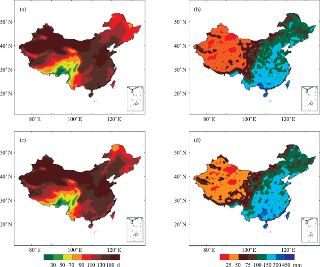
Based on the CCLM simulated data from 1961–2000 and projected data in 2011–2050, the maximum daily rainfall and longest non-precipitation period (daily precipitation less than 0.1 mm) during flood season (April to September) are compared and the results are shown in Figure 5 .
|
|
|
Figure 5. The longest non-precipitation period during flood season (a, c) and the maximum daily rainfall (b, d) in flood season for 1961–2000 (a, b) and 2011–2050 (c, d) |
Figure 5 a shows that the longest nonprecipitation period during flood season for 1961–2000 is above 150 d in western Northwest China and Inner Mongolia, eastern North China and the northern Huanghuai region. It is followed by 130–150 d in eastern Northwest China, the southern Jianghan and Huanghuai regions, the central-western Jiangnan region and most parts of South China; in the remaining parts of China they are below 130 d. Figure 5 b shows that the area with maximum daily rainfall above 150 mm is mainly concentrated in South China, the eastern part of North China and some parts of southern Northeast China. In most part of Northeast China, eastern Northwest China, the Huanghuai and Jianghuai regions, the maximum daily rainfall is 100–150 mm. In western China, the maximum daily rainfall is generally less than 100 mm.
Comparing Figure 5 c with 5a, it can be seen that the longest non-precipitation period during flood season will increase significantly 20–30 d in most part of Northeast China, northeastern Northwest China and some parts of the Huanghuai region in 2011–2050. In most parts of South China, it will decrease about 20 d. Comparing Figure 5 d with 5b, it is obvious that the maximum daily rainfall will increase in southeastern Northwest China, some parts of the Huanghuai and Jianghuai regions, and some parts of south coastal areas, with the rate of 50–150 mm. It means that the frequency of droughts will increase in most regions of Northeast China, central Inner Mongolia, northeastern Northwest China, and some parts of the Huanghuai region, and the probability of floods will also increase in southeastern Northwest China, some parts of central-eastern Northeast China and Inner Mongolia, and some areas of the Huanghuai and Jianghuai regions. These results are consistent with the pattern of increasing precipitation extremes reflected in the trends of kurtosis and skewness.
6. Conclusions and discussion
Based on observed precipitation data and CCLM simulated and projected (SRES A1B) data, the indices such as kurtosis, skewness, maximum daily rainfall and the longest non-precipitation period during flood season were analyzed. The probability method and extreme value theory were applied to analyze the variation characteristics of daily precipitation distribution for 1961–2000 and 2011–2050 in China. The results are as follows:
(1) Comparison of the kurtosis and skewness of the daily precipitation series of CCLM simulations with observations for 1961–2000 reveals that their spatial correlation coefficients are above 0.75. The CCLM can well capture the spatial and probability distribution of daily precipitation over China and is suitable for applications in evaluating the spatial-temporal distribution of precipitation in the future.
(2) Comparing the trends of kurtosis and skewness in 1961–2000 with those of 2011–2050, it becomes clear that the precipitation kurtosis and skewness will increase significantly in Southwest China, some parts of the Jianghuai region, central-eastern Northeast China and Inner Mongolia in 2011–2050. This means that precipitation extremes tend to increase. On the contrary, in the regions with decreasing kurtosis and skewness, such as some parts of central and western Northwest China, precipitation extremes will decrease.
(3) In 2011–2050, the longest non-precipitation period during flood season will increase significantly in most parts of Northeast China, central Inner Mongolia and some parts of the Huanghuai region. The maximum daily rainfall will also increase in central-eastern Northeast China and Inner Mongolia and some parts of the Huanghuai and Jianghuai regions. These changing patterns of precipitation extremes are also reflected in the trends of kurtosis and skewness.
Due to the vast territory and complicated topography in China, there are certain biases for simulations in the present study in regions with sparse gauge stations, e.g., the Qinghai-Tibetan Plateau. Therefore, further studies are needed to implement the methodology of current study in a multi-model, multi-scenario comparison study with error correction based on historical data error correction to reduce the uncertainties of the projections.
Acknowledgements
This research was supported by the National Basic Research Program of China (No. 2010CB428401), National Natural Science Foundation of China (No. 40911130506). We are grateful to the National Meteorological Information Center and Potsdam Institute for Climate Change Impact Research for providing the data.
References
- Fang et al., 2007 Q.-M. Fang, D.-Y. Gong, R. Mao; Changes of daily precipitation of China in wintertime during the last 46 years; Scientia Geographica Sinica (in Chinese), 27 (5) (2007), pp. 711–717
- Fischer et al., 2013 T. Fischer, C. Menzel, B.-D. Su, et al.; Simulated and projected climate extremes in the Zhujiang River Basin, South China, using the regional climate model COSMO-CLM; International Journal of Climatology (2013) http://dx.doi.org/10.1002/joc.3643
- Groisman et al., 1999 P. Groisman, T. Karl, D. Easterling, et al.; Changes in the probability of extreme precipitation: Important indicators of climate change; Climate Change, 42 (1999), pp. 243–283
- Li et al., 2008 H.-M. Li, T.-J. Zhou, R.-C. Yu; Analysis of July-August daily precipitation characteristics variation in eastern China during 1958–2000; Chinese Journal of Atmospheric Sciences (in Chinese), 32 (3) (2008), pp. 358–370
- Lin and Liu, 2008 E.-D. Lin, Y.-J. Liu; Advance in new scenarios of greenhouse gas emission and climate change; Scientia Agricultura Sinica (in Chinese), 41 (6) (2008), pp. 1700–1707
- Liu and Ding, 2010 H.-W. Liu, Y.-H. Ding; Analysis of daily precipitation characteristics over North China during rainy seasons; Chinese Journal of Atmospheric Sciences (in Chinese), 34 (1) (2010), pp. 13–22
- Ning and Qian, 2008 L. Ning, Y.-F. Qian; Analyses on trends of annual and seasonal four kinds of daily precipitation in China; Plateau Meteorology (in Chinese), 27 (5) (2008), pp. 1010–1020
- Sheng et al., 2006 Z. Sheng, S.-Q. Xie, C.-Y. Pan; Probability Theory and Mathematical Statistics (in Chinese), Higher Education Press (2006), pp. 250–253
- Su et al., 2006 B.-D. Su, T. Jiang, G.-Y. Ren, et al.; Observed trends of precipitation extremes in the Yangtze River Basin during 1960 to 2004; Advances in Climate Change Research (in Chinese), 2 (1) (2006), pp. 9–14
- Tang and Yang, 2006 G.-A. Tang, X. Yang; ArcGIS Spatial Analysis GIS Tutorial (in Chinese), Science Press (2006), pp. 191–195
- UNDP, 2006 UNDP; Beyond scarcity: Power, poverty and the global water crisis, human development report (2006), p. 2006
- Wang, 2008 X.-M. Wang; The misunderstanding of the concept of skewness and kurtosis; Statistics and Decision (in Chinese), 12 (264) (2008), pp. 145–146
- Zhai et al., 1999 P.-M. Zhai, F.-M. Ren, Q. Zhang; Detection of trends in China’s precipitation extremes; Acta Meteorologica Sinica (in Chinese), 57 (2) (1999), pp. 208–215
Document information
Published on 15/05/17
Submitted on 15/05/17
Licence: Other
Share this document
Keywords
claim authorship
Are you one of the authors of this document?
