Abstract
Based on the satellite data from the Climate Prediction Center morphing (CMORPH) at very high spatial and temporal resolution, the effects of urbanization on precipitation were assessed over the Pearl River Delta (PRD) metropolitan regions of China. CMORPH data well estimates the precipitation features over the PRD. Compared to the surrounding rural areas, the PRD urban areas experience fewer and shorter precipitation events with a lower precipitation frequency (ratio of rainy hours, about 3 days per year less); however, short-duration heavy rain events play a more significant role over the PRD urban areas. Afternoon precipitation is much more pronounced over the PRD urban areas than the surrounding rural areas, which is probably because of the increase in short-duration heavy rain over urban areas.
Keywords
CMORPH ; Urbanization effects ; Pearl River Delta
1. Introduction
With rapid economic growth, China is undergoing rapid urbanization. On December 31, 2013, the urban area was 8.58 million hm2 . Urbanization is one of the very extreme cases of land-use change. Compared with the surrounding rural areas, the energy and water budgets in urban areas are altered owing to changes in the structure of the planetary boundary layer and radiation process, because of the heterogeneous surface properties, high-rise buildings, and anthropogenic aerosols. These changes then affect local airflow and circulation, resulting in changes in the weather, local weather, and climate. A well-recognized phenomenon of the urban climate is the urban heat island, in which there is a temperature contrast between a city and the surrounding rural areas (Collier, 2006 ). Zhou et al. (2004) presented evidence for a significant urbanization effect on climate based on analysis of land-use changes and surface temperature in Southeast China, which experienced rapid urbanization. The warming of urbanization effect nearly reaches 0.05 °C per decade. Ren and Zhou (2014) and Ren et al., 2012 ; Ren et al., 2008 evaluated the urbanization effects on trends of extreme temperature in China mainland, by applying a homogenized daily temperature dataset of the national reference climate stations and basic meteorological stations, and a rural station network previously developed. It is pointed out that urbanization effects are statistically significant for daily minimum temperature, maximum temperature, and declining diurnal temperature range. Besides urbanization effects on the summer days, tropical nights, and frost days are significant. An insignificant urbanization effect is detected for icing days.
However, the influence of urbanization on local precipitation is still a matter of debate. In general, results from the metropolitan meteorological experiment have shown that during the summer months, urban effects lead to increased precipitation at distance of 30–75 km away from the city center. This finding has been confirmed in many previous studies (Landsberg, 1970 ; Sanderson and Gorski, 1978 ; Bornstein and Lin, 2000 ; Shepherd et al., 2002 ; Shepherd, 2006 ; Mote et al., 2007 ; Hand and Shepherd, 2009 ; Halfon et al., 2009 ; Shepherd, 2005 ). However, using satellite data that reveals plumes of reduced cloud particle size and suppressed precipitation, Rosenfeld (2000) demonstrated that urban and industrial air pollution can prevent precipitation in urban areas. This finding differs from previous results concerning the enhancement of precipitation by urbanization. Measurements obtained by the Tropical Rainfall Measuring Mission satellite have demonstrated that both cloud droplet coalescence and ice precipitation formation are inhibited in polluted clouds. However, precipitation is a very important process in the global water and energy cycles. Thus, understanding the effects of urbanization on precipitation is very important for ongoing climate diagnostics and prediction.
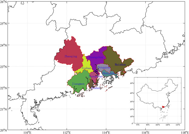
Our study region is the Pearl River Delta (PRD), which is located in the southern Chinese province of Guangdong, and experienced rapid urbanization. In this paper, the PRD is anchored by the cities of Guangzhou, Foshan, Jiangmen, Zhaoqing, Dongguan, Huizhou, Zhongshan, Zhuhai, Macao, Shenzhen, and Hong Kong (Fig. 1 ). On the basis of observations in 1988–1996, Kaufmann et al. (2007) suggested that urbanization in the PRD has reduced local precipitation because of the changes in the surface hydrology. Seto and Kaufmann (2009) further indicated that the precipitation reduction induced by urban land cover change over the PRD occurs mainly during the winter months. However, some recent studies reported an increase in precipitation and severe thunderstorms over the PRD (Meng et al., 2007 ; Li et al., 2009 ; Zhang et al., 2009 ; Li et al., 2011 ; Liao et al., 2011 ). Although these results provide evidence that convection and precipitation can be enhanced or initiated by urban regions, the urbanization effects over the PRD on local precipitation are still unclear. But it is very significant for us to understand the clear effects of urbanization on precipitation. This can help to improve the weather prediction and climate diagnostics over the PRD region. So in this study, we use satellite data with high spatial and temporal resolution to discuss the urbanization effect on precipitation over the PRD.
|
|
|
Fig. 1. The location of the Pearl River Delta. |
2. Data
Climate Prediction Center morphing (CMORPH) technique produces global precipitation analyses at very high spatial (0.07277° lat/lon, about 8 km at the equator) and temporal (30 min) resolution. This technique uses precipitation estimates that have been exclusively derived from low orbiter satellite microwave observations (Joyce et al., 2004 ). The features of precipitation estimates are transported via spatial propagation information that is obtained entirely from geostationary satellite IR data. Specifically, CMORPH uses motion vectors derived from half-hourly interval geostationary satellite IR imagery to propagate the relatively high-quality precipitation estimates derived from passive microwave data. In addition, the shape and intensity of the precipitation features are modified (morphed) during the time intervals between microwave sensor scans by performing a time-weighted linear interpolation. This process yields spatially and temporally complete microwave-derived precipitation analyses that are independent of the infrared temperature field. The CMORPH data has been generated since 2002. The data is archived and distributed at ftp://ftp.cpc.ncep.noaa.gov/precip/CMORPH_V1.0 . In this paper, the data of version 1.0 is used. The time range in this study is from 1998 to 2013. The accuracy and reliability of this data are evaluated and important results in atmospheric science are gained (Gebregiorgis and Hossain, 2015 ; Ghajarnia et al., 2015 ; Li et al., 2015 ). This high-quality data is used to analyze the effects of urbanization on precipitation. Jiang and Tang (2011) concluded that urbanization has significant effects on the precipitation intensity in summer and autumn over the Yangtze River Delta.
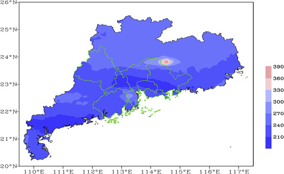
Firstly, we assess the CMORPH datas performance over the PRD. Fig. 2 shows a comparison of annual precipitation over Guangdong province for CMOPRH and rain gauge data obtained from Guangdong Provincal Meteorological Service for 1998–2010. Although the satellite data underestimates the precipitation amount in South China, it mainly captures the precipitation pattern, with two typical rainstorm centers at Yangjiang and Longmen. Thus, CMORPH data can be used to analyze the effects of urbanization on precipitation over the PRD.
|
|
|
Fig. 2. Spatial distribution of annual precipitation over Guangdong province for 1998–2010 mean, (a) CMORPH data, (b) rain gauge data (unit: mm). The green regions denote the locations of the PRD metropolitan regions. |
3. Results
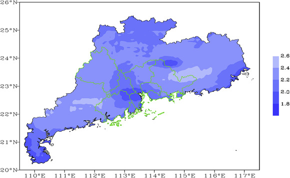
Because the CMORPH data has a high temporal resolution of 30 min, precipitation events could be analyzed with an accuracy of hours, rather than the traditional rainy day analysis. In this study, we define one precipitation event as the cessation of continuous precipitation. The precipitation duration is defined as the hours from the beginning to the end of the precipitation event. Fig. 3 shows the spatial distribution of annual precipitation events over Guangdong province for 1998–2013 mean. Notably, the annual precipitation events over the PRD are low, especially in Foshan, Guangzhou, and Dongguan, central areas of the PRD. This finding indicates that the PRD experiences fewer precipitation events.
|
|
|
Fig. 3. Spatial distribution of annual precipitation events over Guangdong province (1998–2013 mean). |
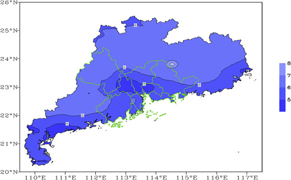
Fig. 4 shows the spatial distribution of the mean duration of precipitation event over Guangdong province for 1998–2013. It is obvious that the precipitation duration over the PRD is shorter in comparison with the surrounding rural areas. Fig. 3 ; Fig. 4 suggest that urbanization remarkably influences precipitation over the PRD, causing fewer and shorter precipitation events.
|
|
|
Fig. 4. Spatial distribution of the mean duration of precipitation event over Guangdong province (1998–2013 mean, unit: h). |
We defined precipitation frequency as the ratio of the rainy hours in CMORPH data to the total hours. Fig. 5 shows the spatial distribution of precipitation frequency over Guangdong province for 1998–2013. The PRD has lower precipitation frequency compared to the surrounding rural areas, nearly one percent less, about three days per year. This means that the urban area has more time with no rain. This finding can be explained by Rosenfeld (2000) . Cloud droplet coalescence and ice precipitation formation are inhibited in urban areas by the polluted air (Rosenfeld, 1999 ; Rosenfeld et al., 2008 ). This is not a favorable result for environmental protection because precipitation is very important for the wet deposition of polluted air to eliminate aerosols.
|
|
|
Fig. 5. Spatial distribution of precipitation frequency over Guangdong province (1998–2013, unit: %). |
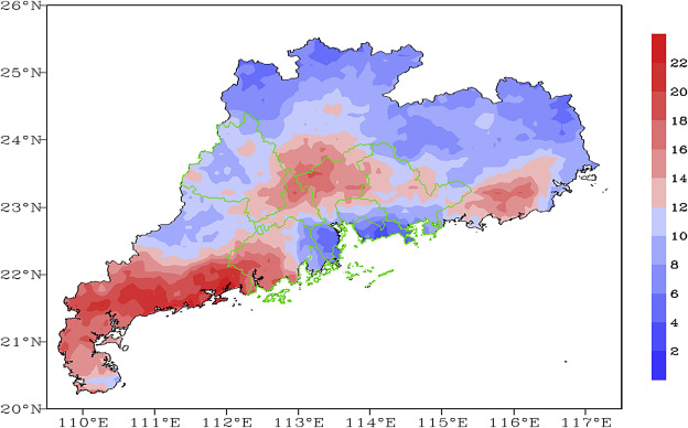
Short-duration heavy rain is a type of severe convective weather and can cause large losses of both property and life. We defined short-duration heavy rain as precipitation amount exceeding 20 mm in an hour. Fig. 6 shows the spatial distribution of the percentage of short-duration heavy rain amount to total precipitation over Guangdong province for 1998–2013. There are high value centers in this figure. The first one is in the Yangjiang and Maoming region, located at the southwest to the PRD. The second one is in the Haifeng and Lufeng region. These two regions are the well-known rainstorm centers in Guangdong province. Because they are located in the south slope of the main mountains, the topographic lifting effect plays a very important role in the heavy rain events. The last one is located in northern PRD, particularly in Foshan and Guangzhou. This result suggests that short-duration heavy rain is more frequent in this area. This finding is in agreement with the conclusion of Li et al. (2011) , the PRD experiences much stronger precipitation compared to the surrounding nonurban region because of urban effects.
|
|
|
Fig. 6. Spatial distribution of short-duration heavy rain amount relative to total precipitation over Guangdong province for 1998–2013 (unit: %). |
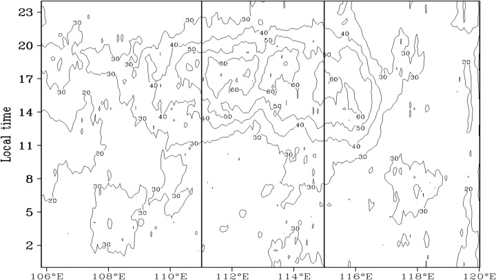
Recent studies have shown that the diurnal rainfall pattern is strongly modulated by the effects of urbanization (Burian and Shepherd, 2005 ; Mote et al., 2007 ). To investigate further aspects of precipitation over the PRD, we studied the diurnal variations in precipitation over this region. Fig. 7 shows the diurnal variations in precipitation along the central latitude (23.5°N) of the PRD during 1998–2013 based on CMOPRH data. There are substantial differences in the diurnal variations in precipitation between the PRD and the surrounding nonurban areas. Afternoon precipitation is much more pronounced over the PRD urban areas than over the surrounding nonurban areas, which contributes to the increase in short-duration heavy rain over urban areas.
|
|
|
Fig. 7. Diurnal variations of precipitation along the center latitude (23.5°N) of the PRD during 1998–2013 based on CMOPRH data (Regions between the two solid lines illustrates the PRD metropolitan regions. Unit: mm h−1 ). |
4. Conclusions and discussion
Based on the satellite data from the CMORPH at a very high spatial and temporal resolution, we assessed the effects of urbanization on precipitation over the PRD metropolitan regions of China. Although the CMORPH data underestimates the precipitation amount, the precipitation features over the PRD are simulated fairly well. Compared to the surrounding rural areas, the PRD urban areas experience fewer and shorter precipitation events, with a lower precipitation frequency. Short-duration heavy rain plays a more important role over the PRD urban areas. Afternoon precipitation is much more pronounced over the PRD areas than the surrounding areas, and this is probably associated with the increase in short-duration heavy rain over the urban areas.
As shown in other studies, urbanization not only modifies the exchange of heat, water, and momentum between the land surface and overlying atmosphere (Crutzen, 2004 ) but also changes the composition of the atmosphere over urban areas (Pataki et al., 2003 ). More research (Ramanathan et al., 2001 ) is required to determine the dominant factors that cause the local precipitation changes over the PRD areas and to reveal the mechanisms controlling the urbanization effect on precipitation.
Acknowledgements
This work was supported by the National Natural Science Foundation of China (41375050 ). The authors are very grateful to the editor and reviewers' valuable comments. CMORPH data used in this study was processed by the National Oceanic and Atmospheric Adminstration (NOAA).
References
- Bornstein and Lin, 2000 R. Bornstein, Q. Lin; Urban heat islands and summertime convective thunderstorms in Atlanta: three case studies; Atmos. Environ., 34 (2000), pp. 507–516
- Burian and Shepherd, 2005 S.J. Burian, J.M. Shepherd; Effect of urbanization on the diurnal rainfall pattern in Houston; Hydrol. Process., 19 (2005), pp. 1089–1103
- Collier, 2006 C.G. Collier; The impact of urban areas on weather; Q. J. R. Meteorol. Soc., 132 (614) (2006), pp. 1–25 http://dx.doi.org/10.1256/qj.05.199
- Crutzen, 2004 P.J. Crutzen; New directions: the growing urban heat and pollution island effect—impact on chemistry and climate; Atmos. Environ., 38 (2004), pp. 3539–3540
- Gebregiorgis and Hossain, 2015 A.S. Gebregiorgis, F. Hossain; How well can we estimate error variance of satellite precipitation data around the world?; Atmos. Res., 154 (2015), pp. 39–59
- Ghajarnia et al., 2015 N. Ghajarnia, A. Liaghat, P.D. Arasteh; Comparison and evaluation of high resolution precipitation estimation products in Urmia Basin-Iran; Atmos. Res., 158 (2015), pp. 50–65
- Halfon et al., 2009 N. Halfon, Z. Levin, P. Alpert; Temporal rainfall fluctuations in Israel and their possible link to urban and air pollution effects; Environ. Res. Lett., 4 (2009), p. 025001
- Hand and Shepherd, 2009 L.M. Hand, J.M. Shepherd; An investigation of warm-season spatial rainfall variability in Oklahoma city: possible linkages to urbanization and prevailing wind; J. Appl. Meteorol. Climatol., 48 (2009), pp. 251–269
- Jiang and Tang, 2011 Z.-H. Jiang, Z.-F. Tang; Urbanization effects on precipitation over the Yangtze River Delta based on CMORPH data; J. Meteorol. Sci., 31 (4) (2011), pp. 355–364 (in Chinese)
- Joyce et al., 2004 R.J. Joyce, J.E. Janowiak, P.A. Arkin, et al.; CMORPH: a method that produces global precipitation estimates from passive microwave and infrared data at high spatial and temporal resolution; J. Hydrometeorol., 5 (3) (2004), pp. 487–503
- Kaufmann et al., 2007 R.K. Kaufmann, K.C. Seto, A. Schneider, et al.; Climate response to rapid urban growth: evidence of a human-induced precipitation deficit; J. Clim., 20 (2007), pp. 2299–2306
- Landsberg, 1970 H.E. Landsberg; Man-made climate changes; Science, 170 (1970), pp. 1265–1274
- Li et al., 2011 W.-B. Li, S. Chen, G.-X. Chen, et al.; Urbanization signatures in strong versus weak precipitation over the Pearl River Delta metropolitan regions of China; Environ. Res. Lett., 6 (3) (2011) http://dx.doi.org/10.1088/1748-9326/6/3/034020
- Li et al., 2009 W.-B. Li, Y.-D. Du, G.-D. Wang, et al.; Urbanization effects on precipitation over the Pearl River Delta based on satellite data; J. Atmos. Sci., 33 (6) (2009), pp. 1259–1266 (in Chinese)
- Li et al., 2015 Z. Li, D.-W. Yang, B. Gao, et al.; Multiscale hydrologic applications of the latest satellite precipitation products in the Yangtze River Basin using a distributed hydrologic model; J. Hydrometeorol., 16 (1) (2015), pp. 407–426
- Liao et al., 2011 J.-B. Liao, X.-M. Wang, Y.-X. Li, et al.; An analysis study of the impacts of urbanization on precipitation in Guangzhou; J. Meteorol. Sci., 31 (4) (2011), pp. 384–390 (in Chinese)
- Meng et al., 2007 W.-G. Meng, J.-H. Yan, H.-B. Yu; Possible impact of urbanization on severe thunderstorms over Pearl River Delta; Chin. J. Atmos. Sci., 31 (2007), pp. 364–376 (in Chinese)
- Mote et al., 2007 T.L. Mote, M.C. Lacke, J.M. Shepherd; Radar signatures of the urban effect on precipitation distribution: a case study for Atlanta, Georgia; Geophys. Res. Lett., 34 (2007), p. L20710
- Pataki et al., 2003 D.E. Pataki, D.R. Bowling, J.R. Ehleringer; Seasonal cycle of carbon dioxide and its isotopic composition in an urban atmosphere: anthropogenic and biogenic effects; J. Geophys. Res., 108 (2003), p. 4735
- Ramanathan et al., 2001 V. Ramanathan, P.J. Crutzen, J.T. Kiehl, et al.; Atmosphere-aerosols, climate, and the hydrological cycle; Science, 294 (5549) (2001), pp. 2119–2124 http://dx.doi.org/10.1126/science.1064034
- Ren and Zhou, 2014 G.-Y. Ren, Y.-Q. Zhou; Urbanization effect on trends of extreme temperature indices of national stations over Mainland China, 1961–2008; J. Clim., 27 (6) (2014), pp. 2340–2360 http://dx.doi.org/10.1175/JCLI-D-13-00393.1
- Ren et al., 2008 G.-Y. Ren, Y.-Q. Zhou, Z.-Y. Chu, et al.; Urbanization effects on observed surface air temperature trends in north China; J. Clim., 21 (6) (2008), pp. 1334–1348 http://dx.doi.org/10.1175/2007JCLI1348.1
- Ren et al., 2012 G.-Y. Ren, Y.-H. Ding, Z.-C. Zhao, et al.; Recent progress in studies of climate change in China; Adv. Atmos. Sci., 29 (5) (2012), pp. 958–977 http://dx.doi.org/10.1007/s00376-012-1200-2
- Rosenfeld, 1999 D. Rosenfeld; TRMM observed first direct evidence of smoke from forest fires inhibiting rainfall; Geophys. Res. Lett., 26 (20) (1999), pp. 3105–3108 http://dx.doi.org/10.1029/1999GL006066
- Rosenfeld, 2000 D. Rosenfeld; Suppression of rain and snow by urban and industrial air pollution; Science, 287 (5459) (2000), pp. 1793–1796 http://dx.doi.org/10.1126/science.287.5459.1793
- Rosenfeld et al., 2008 D. Rosenfeld, U. Lohmann, G.B. Raga, et al.; Flood or drought: how do aerosols affect precipitation?; Science, 321 (5894) (2008), pp. 1309–1313 http://dx.doi.org/10.1126/science.1160606
- Sanderson and Gorski, 1978 M.L. Sanderson, R. Gorski; The effect of metropolitan Detroit–Windsor on precipitation; J. Appl. Meteorol., 17 (1978), pp. 423–427
- Seto and Kaufmann, 2009 K.C. Seto, R.K. Kaufmann; Urban growth in South China and impacts on local precipitation; Fifth Urban Research Sympathy (2009) Marseille
- Shepherd, 2005 J.M. Shepherd; A review of current investigations of urban-induced rainfall and recommmendations for the future; Earth Interact., 9 (12) (2005)
- Shepherd, 2006 J.M. Shepherd; Evidence of urban-induced precipitation variability in arid climate regimes; J. Arid Environ., 67 (2006), pp. 607–628
- Shepherd et al., 2002 J.M. Shepherd, H. Pierce, A.J. Negri; Rainfall modification by major urban areas: observations from spaceborne rain radar on the TRMM satellite; J. Appl. Meteorol., 41 (2002), pp. 689–701
- Zhang et al., 2009 Q. Zhang, Y.-X. Chong, S. Becker, et al.; Trends and abrupt changes of precipitation extremes in the Pearl River basin; China Atmos. Sci. Lett., 10 (2009), pp. 132–144
- Zhou et al., 2004 L.-M. Zhou, R.E. Dickinson, Y.-H. Tian, et al.; Evidence for a significant urbanization effect on climate in China; Proc. Natl. Acad. Sci. U. S. A., 101 (26) (2004), pp. 9540–9544
Document information
Published on 15/05/17
Submitted on 15/05/17
Licence: Other
Share this document
Keywords
claim authorship
Are you one of the authors of this document?
